DCR Plans to Remove Car Lanes, Add Buffered Bikeways on the Arborway
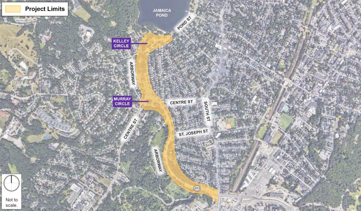
The state Department of Conservation and Recreation (DCR) is studying potential safety improvements to the braid of Emerald Necklace roadways that connect Forest Hills to Jamaica Pond. Courtesy of the Massachusetts DCR.
The state Department of Conservation and Recreation (DCR) has announced plans to replace motor vehicle lanes with wide buffered bike lanes along three roadway sections of the Arborway in Jamaica Plain as part of a suite of short-term safety improvements.
The DCR’s “Arborway Parkways Improvement Project” is examining possible new designs for the mile-long stretch of multi-lane roadways between Jamaica Pond and the Forest Hills T station for a reconstruction project that would begin in 2021. According to DCR officials, the project's guiding principles include improving safety, accessibility, and connectivity for all users of the Arborway, and honoring park designer Frederick Law Olmsted’s historic vision for the parkland.
But while a longer-term project is being designed for future construction, DCR is also proposing short-term improvements that can be implemented in the meantime. Construction crews were at work over the summer to repair sidewalks and upgrade crosswalk ramps; now, DCR is planning to re-stripe lanes on the existing roadways to better organize traffic and create dedicated on-road lanes for bikes.
In a phone conversation Monday morning, Sarah Freeman, an Arborway neighbor and a longtime advocate for safer bike routes through the traffic-choked park land, was enthusiastic about the proposed changes.
"I hope they’ll do it, and I hope it goes well so they'll have some confidence in doing this for their more permanent design," said Freeman. "The good thing about paint is that you can tweak it, it’s not a lifetime commitment. I’m hopeful that it’ll work."
Under the DCR's proposal, the outer "carriageway" roads between Murray and Kelley Circles would each lose one motor vehicle lane, and lane markings will attempt to funnel most motor vehicle traffic into the four-lane center roadway:
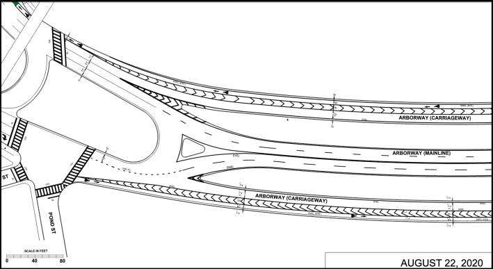
"We found that eight lanes in the carriage road section is not necessary to carry the amount of traffic we counted," notes Jeffrey Parenti, DCR’s Deputy Chief Engineer, in a letter outlining the proposal. Though two lanes are being removed, that section of the Arborway will still have six lanes for motor vehicles, which means it will still be wider than adjacent sections of roadway along Jamaica Pond and the Arnold Arboretum.
South of Murray Circle, the DCR proposes a similar road diet on the southbound lanes of the Arborway adjacent to the Arboretum, which would give the Arborway a three-lane cross section between Centre Street and the Forest Hills station area (at this time, no changes are being proposed to the northbound lanes in this section).
Finally, Murray Circle itself would get a major new paint job. "New lines in that rotary, which has none at all today, will better organize movements approaching and within it. This will result in less confusion and fewer crashes," according to Parenti's letter.
In the DCR's draft plan for Murray Circle, some of the new buffered bike routes continue along the carriageways on the edges of the rotary, but there would be no dedicated bike lanes in the rotary for northbound bike traffic coming from Centre Street, and it's unclear how bike traffic would make left turns around the rotary.
But the plan is still being refined; the DCR will solicit input on the draft plans until October 2 at https://www.mass.gov/forms/dcr-public-comments.
For more information:
Download the draft striping plan here.
Project website: Arborway Parkways Improvement Project.
Read More:
Stay in touch
Sign up for our free newsletter