Boston Planning Additional Crosswalk, Bike Lane Upgrades Around Public Garden

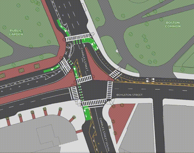
At the west side of the Boston Common, Boylston Street’s two-way cycletrack has taken over a former motor vehicle slip lane into Charles Street, pictured here in November of 2020. A proposed new project would eliminate this asphalt to provide more direct bike and pedestrian crossings through the intersection and create a new gateway to the Boston Common.

On Tuesday morning the City of Boston Transportation Department published conceptual plans for major bike and pedestrian upgrades at five busy intersections around the Public Garden, to improve upon the quick-build improvements that were implemented in 2020 as part of the city's "Connect Downtown" project.
In a new website outlining the project, the Boston Transportation Department (BTD) explains that "our work in 2020 focused on changes that we could make quickly... With this phase of the project, we intend to build lasting changes. We will prioritize people walking and keeping travelers safe. Our work will include new curbs, accessible crosswalks, and traffic signal equipment."
The proposed work would give pedestrians much more space at key intersections – particularly in crosswalks at busy entrance points to the Public Garden.
For bikes, the proposal would also allow two-way bike traffic on Charles Street between the Garden and the Common, and add more robust protection to the existing bike lanes, by replacing flexible-post bollards with more durable curbs in key locations.
The project's most dramatic changes would occur at the complex intersection of Charles Street and Boylston Street, at the southern edge of the Garden and Common. Last year's quick-build project eliminated westbound motor vehicle traffic from Boylston Street and replaced a former right-turn slip lane fro, Boylston to Charles Street (pictured above) with a two-way bike path.
Now, the BTD is proposing to make those changes permanent by eliminating the former right-turn lane altogether, which would expand the Boston Common and simplify the intersection with shorter and more direct crossings for bikes and pedestrians:
The proposal would also allow for two-way bike traffic in the wide bike lane on Charles Street between the two parks, from Boylston to Beacon Street, and allow for a more direct connection into downtown Boston for people riding into the city from the Longfellow Bridge.
However, the project would not make any changes to Charles Street in the Beacon Hill neighborhood, north of Beacon Street. That street segment ranks among the city's busiest bike routes, but still lacks any dedicated infrastructure for bicycle users.
At the northwest corner of the Public Garden, the project would also fill in a notorious gap in downtown Boston's protected bike lane network on Beacon Street near the Fiedler Footbridge, a chaotic intersection where traffic from Storrow Drive pours into the city:
Associated traffic signal upgrades to this intersection would give bikes and pedestrians a dedicated phase to cross Beacon Street and Mugar Way without dodging turning vehicles.
The project would also make more modest changes to the mid-block entrances to the Public Garden on Arlington and Charles Streets with much larger, more visible crosswalks, widened curb ramps, and additional sidewalk widenings.
A BTD spokesperson said that construction on these changes would begin "no sooner than 2023."
BTD is also working on other possible connections to the Connect Downtown bike network in the area. Last summer, BTD started conducting outreach for possible protected bike lanes on Cambridge Street, and the Boston Public Works Department is designing a complete reconstruction of State Street between the Old State House and the waterfront with a protected bike lane and widened sidewalks.
Read More:
Stay in touch
Sign up for our free newsletter