The MBTA has narrowed its options down to 6 potential new routes for new Silver Line bus rapid transit service to Everett, and in hopes of supporting an alternative through Charlestown, City of Boston officials are committing to building dedicated bus lanes on a redesigned Rutherford Avenue between Sullivan Square and the Charles River.
For the past year, the MBTA, MassDOT, and represenatives from the cities of Boston, Somerville, Cambridge, Everett, and Chelsea have been collaborating on the Silver Line Extension Alternatives Analysis, a study that will recommend a new bus rapid transit route (or routes) through the communities on both sides of the lower Mystic River.
The study builds off a 2019 transportation plan from the Lower Mystic Regional Working Group, which endorsed an expansion of the Silver Line’s busways, with routes connecting Everett and Chelsea to Kendall Square and downtown Boston, as one of the highest-impact transportation investments available to the area.
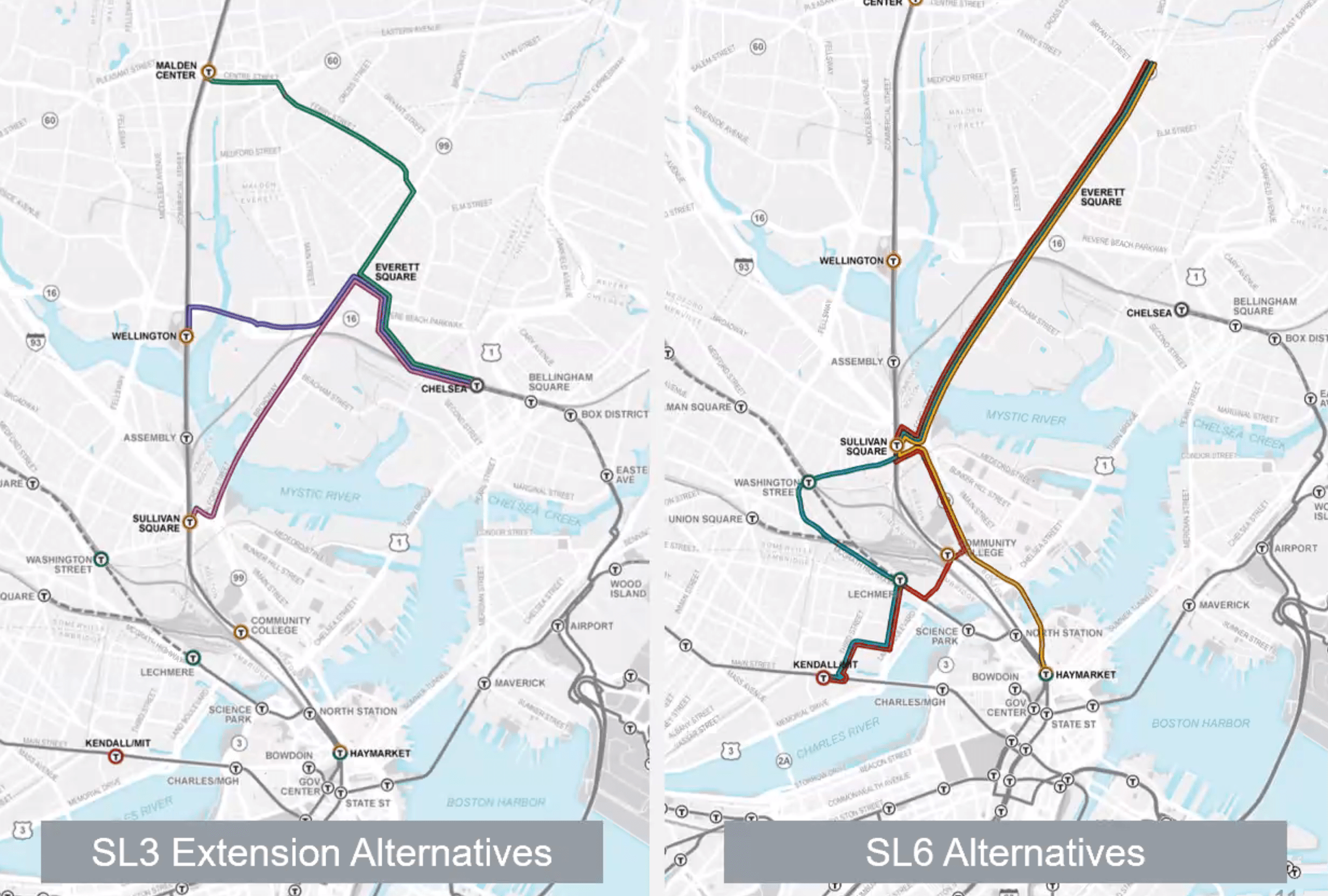
Three of the final 6 alternatives that the MBTA and MassDOT are evaluating in the Silver Line Extension study would extend the existing SL3 route westward from its current terminal in Chelsea to allow for direct connections to the Orange Line via Everett Square. These three alternatives would either end at Malden Center (via Ferry Street), Wellington (via Route 16), or Sullivan Square (via Broadway and the Alford Street bridge).
Three additional route options would create a new Silver Line route - tentatively named "SL6" - that would run along the length of Broadway in Everett to Sullivan Square, then on to either Kendall Square or downtown Boston.
At a virtual meeting of the study's working group earlier this week, Theresa Carr, a study consultant, explained that all 6 potential routes would require redesigned streets and traffic signals to support rapid-transit-like bus service, with dedicated bus lanes “wherever possible.”
Planners are assuming that dedicated bus lanes could be installed to support Silver Line service on the Alford Street Bridge across the Mystic River, on the entire length of Broadway in Everett (where there are currently peak-hour bus lanes that convert to on-street parking lanes at less busy times of day), and through a redesigned Sullivan Square.
The proposed Silver Line service would run every 10-12 minutes during peak hours, and every 15 minutes at other times, according to Carr. But Jay Monty, a transportation planner for Everett, warned that his city would demand higher-frequency bus service in order to justify the loss of on-street parking on Broadway, which is lined with small businesses and public buildings.
“Asking community to sacrifice on-street parking requires better headways," said Monty. "We’d be looking for buses that run every four to five minutes to warrant that tradeoff.”
Study consultants responded that any bus lanes created by this project could also be used by other bus routes, in addition to the proposed Silver Line services, subject to the T's new bus network redesign efforts.
Of the six finalist route alternatives, only two would run in mixed traffic for more than one-fifth of the proposed routes (alternative one would need run in mixed traffic on the relatively narrow Ferry Street to Malden Center, while alternative two would run in mixed traffic on Route 16 to Wellington).
Matt Moran, a transit planner for the City of Boston's Transportation Department, told the project team on Tuesday that the City of Boston was committed to building a bus lane on a redesigned Rutherford Avenue to support bus rapid transit between downtown Boston and Sullivan Square.
“We’ve received direction from our leadership that there will be bus priority on Rutherford Ave. going forward," Moran told the study team at Tuesday's virtual meeting of the study working group. "That’s going to be something we work out on the next few months with our stakeholders.”
Rutherford Avenue, which is currently a crumbling, 10-lane-wide highway that divides the Charlestown neighborhood, has been subject to a decade-long planning effort to redesign the street.
In June 2021, MassDOT and the City of Boston shared a preliminary design that would have reduced the number of car lanes on Rutherford Avenue to make room for widened sidewalks, new open spaces, and a new, physically-protected bike route between the Charles and Mystic Rivers.
The design presented to the public in 2021 would have retained existing underpasses at Austin Street and through Sullivan Square, albeit with fewer lanes, to allow through-running vehicles to drive through the corridor at high speeds without stopping.
A majority of public commenters at that 2021 public hearing either asked for the agencies to revise the design further to make room for dedicated bus lanes on the new street, or to make the roadway even narrower in order to accommodate a future with less car traffic.
Last month, the City quietly posted an update to its project webpage to announce that it would revisit its plans for the Rutherford Avenue redesign once again.
"The City of Boston is currently reevaluating the Rutherford Avenue design to better align it with its Go Boston 2030 goal of increasing transit use citywide," according to an update on the City of Boston's project webpage. "We also want to create a corridor that is equipped to manage potential future growth."
Learn more: