From Framingham to Lowell, Progress Continues on a 25-Mile Bike Path Through Boston’s Western Suburbs

The new Bruce Freeman Rail Trail bridge over Route 2, pictured here in June 2022. Photo by Grecia White.
Several new trail projects are in the works to complete the Bruce Freeman Rail Trail, a proposed 25-mile multi-use pathway that will, when complete, connect Boston’s western suburbs from Lowell to Framingham along the abandoned New Haven Railroad line.
There are currently two completed segments of the Bruce Freeman Rail Trail (BFRT): a 12-mile segment runs from Acton to the southwestern corner of Lowell, and a 2.5-mile segment in the town of Concord.
A new car-free bridge over Route 2 is under construction to link those two segments and connect the towns of Concord and Acton. While technically still under construction, many trail users are already using the bridge; according to town officials, its official completion date will be before November 30.
The bridge connection will make the BFRT accessible to the MBTA’s Fitchburg Line at West Concord station, where folks who would like to ride the trail, but don’t have a bike, can rent one from Concord Bike Share just feet away from the platform.
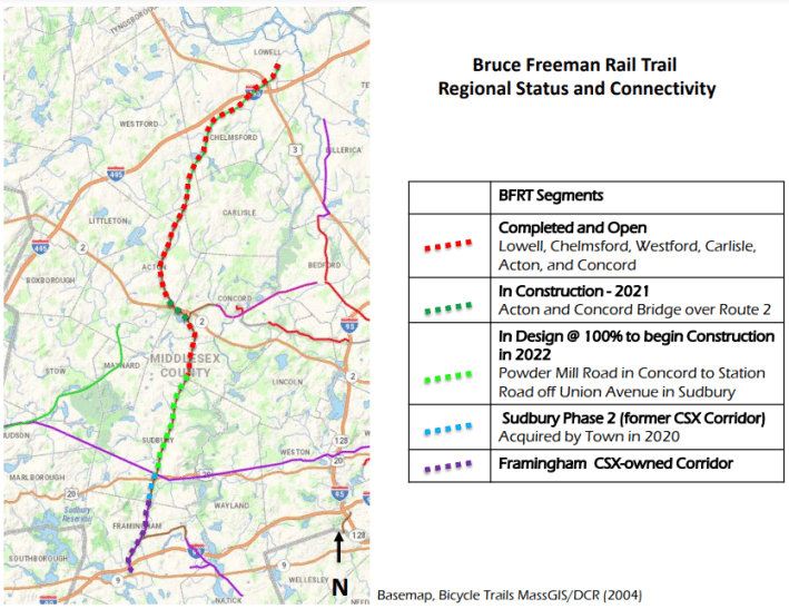
Additional trail sections to extend the trail further south, towards Framingham, and further north, towards downtown Lowell, are currently at different planning stages.
Currently, the 3-mile corridor needed to connect Sudbury and Framingham is owned by CSX, a freight railroad.
At a press event Tuesday morning, where MassDOT and the Massachusetts Executive Office of Energy and Environmental Affairs announced new grant funding to design an extension of the BFRT in Framingham, Framingham Mayor Charlie Sisitsky told StreetsblogMASS that “the city is negotiating with CSX to buy the last segment of the Bruce Freeman Trail corridor, from Route 9 to Sudbury. That's the last link - it makes the connection to Sudbury and all the way to Lowell, and connects us to the Mass. Central Rail Trail. Residents very much want to make this happen."
At a Sudbury town meeting on May 4th, Beth Suedmeyer, Environmental Planner with the Town of Sudbury, presented updates on the project aimed to connect the BFRT from West Concord to Sudbury, otherwise known as “Phase 2D.”
Phase 2D is made up of a 4.4 mile corridor from the existing trail terminus in Concord to “the diamond” where the proposed Mass Central Rail Trail (MCRT) meets the BFRT, near the intersection of Station Road and Union Avenue in Sudbury. From there, the BFRT would connect to a new segment of the MCRT, which will eventually run all the way to downtown Boston.
As of December 2021, a proposed 14-mile MCRT extension between Wayland, Sudbury, and Hudson is at 25% design. When that segment is built, nearly two-thirds of the planned 104-mile Mass. Central Rail Trail between Boston and Northampton will be complete.
The phase 2D project on the Bruce Freeman Rail Trail is on schedule for construction later this year, with approximately $12 million in funding from MassDOT and the Federal Highway Administration.
At the Sudbury town meeting, voters also approved a request for $300,000 from the Community Preservation Act Fund in order to better understand the costs and timelines associated with extending the BFRT further south from the intersection of Station Road and Union Avenue in Sudbury, where Phase 2D ends, south to the Framingham town line.
The extension would include a critical ¼-mile link to Boston Post Road/Route 20 where a number of businesses are located, including a grocery store and a T.J. Maxx.
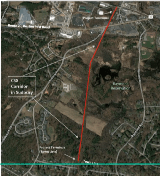
Station Road and Union Avenue in Sudbury, across Route 20/Boston Post Road to the Framingham town line.
In Lowell, a gateway city 30 miles northwest of Boston, another extension project is underway to bring the BFRT closer to the city’s downtown.
Last summer, the City of Lowell began construction on the Lowell Connector Trail Project, which would extend from the Cross Point Towers parking lot where the trail currently ends, to the Concord River Greenway Park, a multi-use linear park currently under construction that will eventually cover 1,200 feet from Davidson Street to Lawrence Street; the two trailheads where people can currently access the completed sections of the Greenway.
Upon completion of the Connector Trail in Lowell, the BFRT will eventually connect to other nearby trail projects currently underway, resulting in a cascading effect that would add multiple connections to the region's trail network. This includes the Merrimack River Trail, a 50‐mile long bicycle and pedestrian trail along the Merrimack River starting from Tyngsborough at the New Hampshire/Massachusetts border and ending in Newbury Massachusetts; traversing a total of 17 communities along the way.
Additionally, the Connector Trail will also link the BFRT to the Bay Circuit Trail, a 230-mile walking trail intended to serve as an “‘outer Emerald Necklace,’— in other words, a greenbelt that would mirror the famous string of Frederick Law Olmsted-designed parks throughout Boston,” according to the trail’s website.
Folks interested in exploring the trail as well as learning more about its cultural and ecological history, can read the “Welcome to Bay Circuit Trail & Greenway Storymap” while they ride the MBTA’s Commuter Rail to one of the trail’s many train accessible sections.
Stay in touch
Sign up for our free newsletter