Skip to Content
Streetsblog Massachusetts home
Log In
Trails

Lawrence Project Will Complete An Off-Street Path From Merrimack River to NH Border

An aerial view of the project area showing the 1.4 mile proposed path extending from Merrimack Street in Lawrence to the Lawrence/Methuen City line to the northwest. Courtesy of MassDOT.

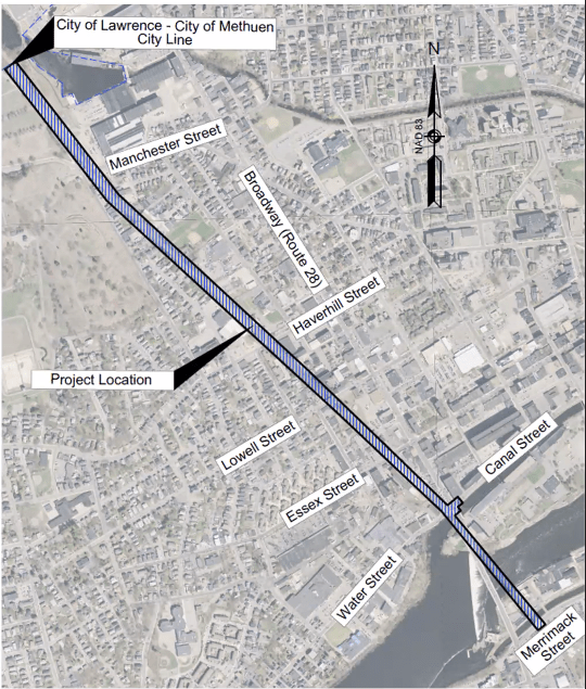
An aerial view of the proposed rail trail in Lawrence. The 1.4 mile path would extend from Merrimack Street in South Lawrence to the Lawrence/Methuen City line to the northwest. Courtesy of MassDOT.

In a virtual public hearing last week, MassDOT shared preliminary designs for a proposed rail trail project in Lawrence, adding this gateway city to the growing list of trail projects announced this summer.

Lea este artículo en Español.

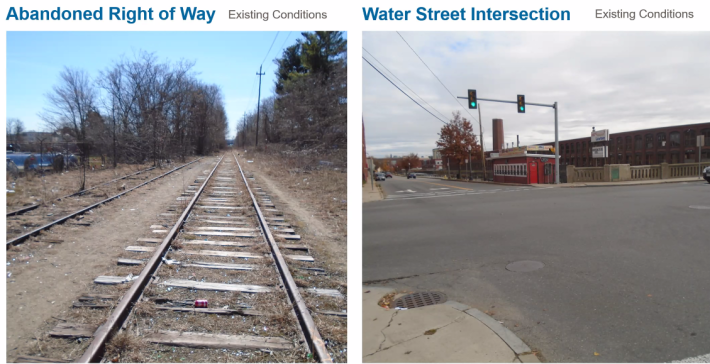
The Lawrence-Manchester Rail Trail project would activate a 1.4 mile stretch of the abandoned Boston and Maine railroad corridor in Lawrence, from Merrimack Street on the south side of the Merrimack River to the existing Methuen Rail Trail at the Methuen/Lawrence city line.

Currently, the rail corridor is unusable by pedestrians or bicyclists due to the presence of train tracks at some sections, overgrown vegetation, and inaccessible ramps, crosswalks, and curbs.

The left image shows the presence of train tracks and litter on a stretch of the corridor. The right image shows the inadequate state of pedestrian infrastructure including lack of crosswalks and non accessible ramps at the Water Street intersection near the southern portion of the project. Courtesy of MassDOT.
The left image shows the presence of abandoned train tracks and litter on a stretch of the corridor. The right image shows the inadequate state of pedestrian infrastructure including lack of crosswalks and non accessible ramps at the Water Street intersection near the southern portion of the project. Courtesy of MassDOT.
The left image shows the presence of train tracks and litter on a stretch of the corridor. The right image shows the inadequate state of pedestrian infrastructure including lack of crosswalks and non accessible ramps at the Water Street intersection near the southern portion of the project. Courtesy of MassDOT.

This project would also complete the Massachusetts portion of a planned 30-mile trail connecting Lawrence to the City of Manchester in New Hampshire. The existing Methuen Rail Trail, completed in 2019, connects to the New Hampshire state line, and from there, an unpaved path continues into the Granite State as the Salem Bike/Ped Corridor.

MassDOT is calling the project an “Alternative Transportation Corridor” (ATC) - an unused right of way transformed to meet the needs of pedestrians and bicyclists and promote less car usage.

“The project also aims to improve transportation equity locally by providing non-motorized vehicle routes to the downtown area,” said Larry Cash, MassDOT Project Manager. He added that the corridor would provide connections to local businesses, amenities, and future trail networks, as well as facilitate future economic development opportunities.

In Lawrence, the corridor runs almost parallel to Broadway/Route 28, a major road lined with Mexican restaurants, panaderias (bakeries) and convenience stores.

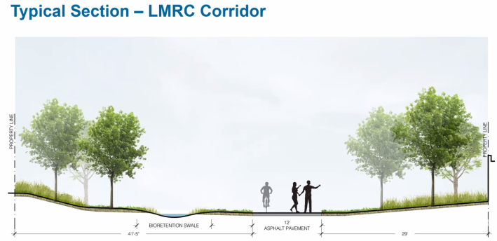
The proposed plan calls for a 12-foot paved shared path, with connecting secondary paths that would connect the project to adjacent neighborhoods and provide access to nearby amenities and community spaces, including the Lawrence Family Development Charter School and Bourgoin Park.

A rendering showing what a typical cross section of what the 12-foot path would look like. A “bioretention swale” would collect and absorb stormwater to prevent the accumulation of standing water along the trail. Courtesy of MassDOT.

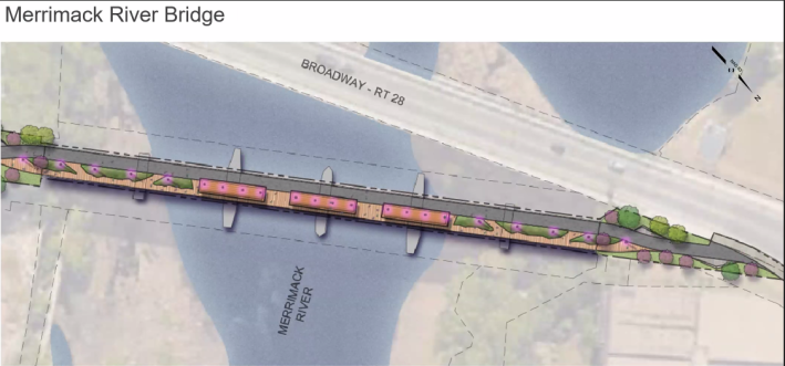
The proposal also includes rehabilitation for three of the four bridges along the corridor: South Canal Bridge, Merrimack River Bridge, and Manchester Street Bridge.

At Merrimack Bridge, folks will be able to enjoy a new deck and rest area spanning the length of the bridge in addition to the 12-foot path. “The rest area will serve as a wonderful assembly area for trail users providing beautiful downstream views of the Merrimack River and the city’s historic mills,” said Jody Trunfio, a design consultant for the project.
At Merrimack Bridge, folks will be able to enjoy a new deck and rest area spanning the length of the bridge in addition to the 12-foot path. “The rest area will serve as a wonderful assembly area for trail users providing beautiful downstream views of the Merrimack River and the city’s historic mills,” said Jody Trunfio, a design consultant for the project. Courtesy of MassDOT,
A rendering of the “Gateway”, a main access point, will feature landscaped areas and amenities for path users. Courtesy of MassDOT.

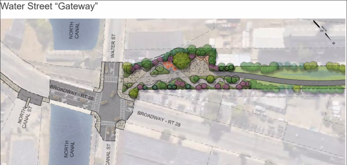
At the “Gateway”, one of the main access points in downtown Lawrence, trail users will “cross the existing Broadway bridge over the North Canal on its east side and then travel a newly signalized and ADA-compliant intersection at Water Street to reconnect to the (corridor),” said Trunfio.

He added he would check with the members of the design team about the feasibility of turning this into a diagonal crossing after a community member expressed this would give users a more direct connection compared to the existing proposal.

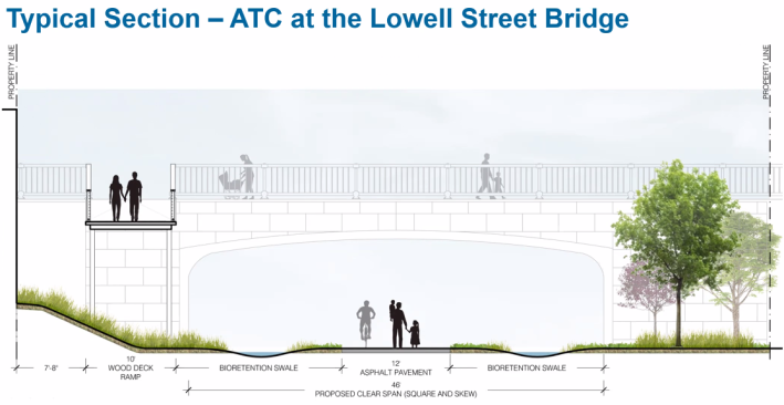
The Lowell Street Bridge, a wooden bridge with structural issues, will be completely replaced with a precast concrete culvert structure over the new trail:

A rendering showing a cross section of the proposed new Lowell Street Bridge which would include protected concrete sidewalks on both sides of the bridge. A 10-foot wood deck ramp shown on the bottom left would provide a new connection between the path and Lowell Street. Courtesy of MassDOT.

Additionally, several upgrades will be made at key intersections where path users meet traffic. ADA-compliant sidewalks and pedestrian ramps will be added to Water, Essex, and Haverhill Streets. Essex and Haverhill Streets will also feature at-grade crossings with rapid-flashing beacons to help alert cars of pedestrians and bicyclists waiting to cross the street.

At the northern terminus, the path will connect to the existing Methuen Rail Trail north of Manchester Street Park, with proposed secondary paths that would connect users to the Spicket River Greenway, a 3.5-mile path that leads back to the east side of downtown Lawrence along the Spicket River. The Methuen Rail Trail runs north to the New Hampshire border, where the rail-trail corridor continues to Manchester as the Granite State Rail Trail.

Funding for the $25 million project cost will primarily come from the Federal Highway Administration who will cover 80 percent of total construction costs, with MassDOT covering the remaining 25 percent.

The project team will continue refining the draft designs in the coming months, and construction could begin in the summer or fall of 2024.

Stay in touch

Sign up for our free newsletter