At Long Last, DCR Releases Master Plan for Safer Parkways
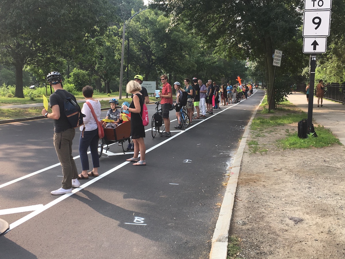
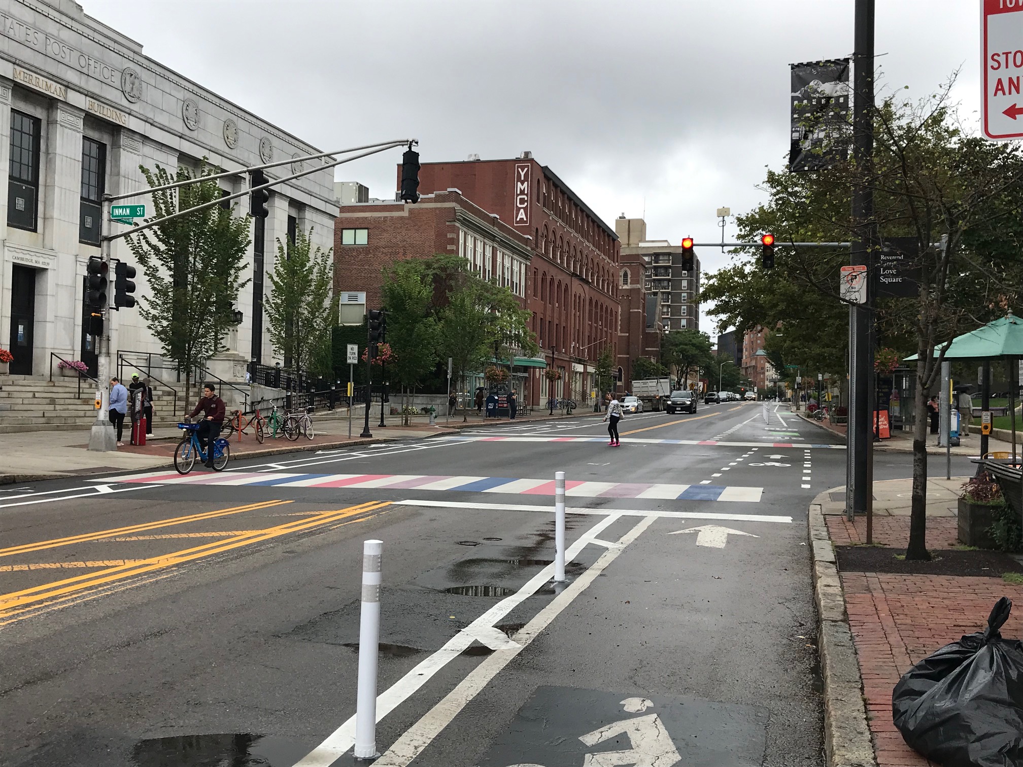
During the morning rush hour on July 11, 2019, dozens of safety advocates gathered to create a “people-protected” barrier for the painted bike lanes on Park Drive in Boston’s Fenway neighborhood.
The Department of Conservation and Recreation (DCR) has finally released its "Parkways Master Plan," one month after StreetsblogMASS exposed the agency's long-running efforts to keep the study out of the public's sight.
As we reported last month, in 2015, DCR signed a contract with Toole Design Group to assess a number of its urban parkways in the greater Boston area and recommend improvements to provide better accommodations for people walking and biking.
But aside from a single public meeting in October 2015, there had been no public updates about the study's progress until Friday afternoon, when DCR published a 278-page master plan document stamped with an "August 2020" publication date.
In an accompanying press release, DCR also revealed Friday that the agency had created an "office of Green Transportation" to lead implementation of the Master Plan's recommendations, and that the design principles of the Master Plan are being incorporated in ongoing agency projects, including the reconstruction of the Arborway in Boston, Hammond Pond Parkway in Newton, and Memorial Drive in Cambridge.
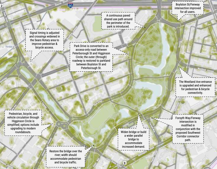
If implemented, the new Master Plan could provide a major boost to bike and pedestrian accessibility, particularly in and around suburban parklands like the Middlesex Fells, Blue Hills Reservation, and the parkways of West Roxbury.
The plan calls for miles of new bike lanes that would be implemented with paint in the short term as part of DCR paving projects, and new physically-separated bikeways or shared-use pathways in major reconstruction projects in the longer term.
The plan also recommends traffic-calming projects for hundreds of intersections and crosswalks across the region, and suggests road diets on streets like Quincy Shore Drive (to provide a safe connection between the Neponset Greenway and Wollaston Beach), Park Drive in Boston, and the Fellsway East roadway in Malden.
Other sections of the newly-released Master Plan offer some potential explanations about why DCR was reluctant to release the document to the public.
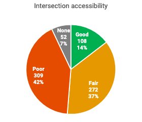
An "existing conditions assessment" shows that 49 percent of the intersections analyzed aren't accessible to pedestrians who use strollers or wheelchairs (see chart at right), 29 percent of parkways, by mileage, do not have any adjacent sidewalks or paths, and, where sidewalks and pathways do exist, 19 percent are in poor condition.
In another part of the plan, a safety analysis highlights Park Drive, Fenway, and Quincy Shore Drive, among other parkways, as high-crash corridors. That analysis is based on older crash data that spans from 2001 to 2014.
In the years since, while that analysis and associated safety recommendations sat on a shelf, several people lost their lives on those same roads, including Paula Sharaga, a Cambridge resident and children's librarian at the Brookline Public Library, who was killed by a truck driver on Park Drive in 2019, and Kwei Wan Chan of Canton, who was killed by an SUV driver while using a crosswalk on Quincy Shore Drive last October.
Besides the outdated crash data, the new Master Plan contains other unusual remnants from its 6-year, bureaucratically-induced coma.
Several of the plan's "short-term" recommendations – like painted bike lanes on Park Drive (pictured above) – were already implemented years ago.
Then there's the plan's record of public engagement – or lack thereof.
While large-scale plans like this one typically come together with numerous public meetings, Toole and DCR hosted only one public meeting for this project, in October 2015.
In a press release accompanying the report's publication on Friday, DCR said that they had "held several meetings with the Urban Parks and Pathways Committee (UPPC), which included representation from MAPC, Mass Bike, the Boston Cyclists Union, Livable Streets, Walk Boston, MassDOT, and numerous community representatives, and served as the forum for public input into the plan."
On February 23, StreetsblogMASS filed a formal public records request to the DCR to obtain a copy of the 2015 contract between the DCR and Toole Design Group, plus copies of any of the agency’s email correspondence related to the study.
That request remains unfulfilled.
Massachusetts law requires that state agencies respond to public records requests within 15 business days. As of June 14, 77 business days have passed since StreetsblogMASS submitted its original request to DCR.
StreetsblogMASS intends to keep pursuing the request in order to learn why the publication of the Master Plan was stalled for so long.
Learn more:
Download the DCR Parkways Master Plan.
Stay in touch
Sign up for our free newsletter