Growing Coalition Presses for ‘At-Grade’ Allston Turnpike Alternative
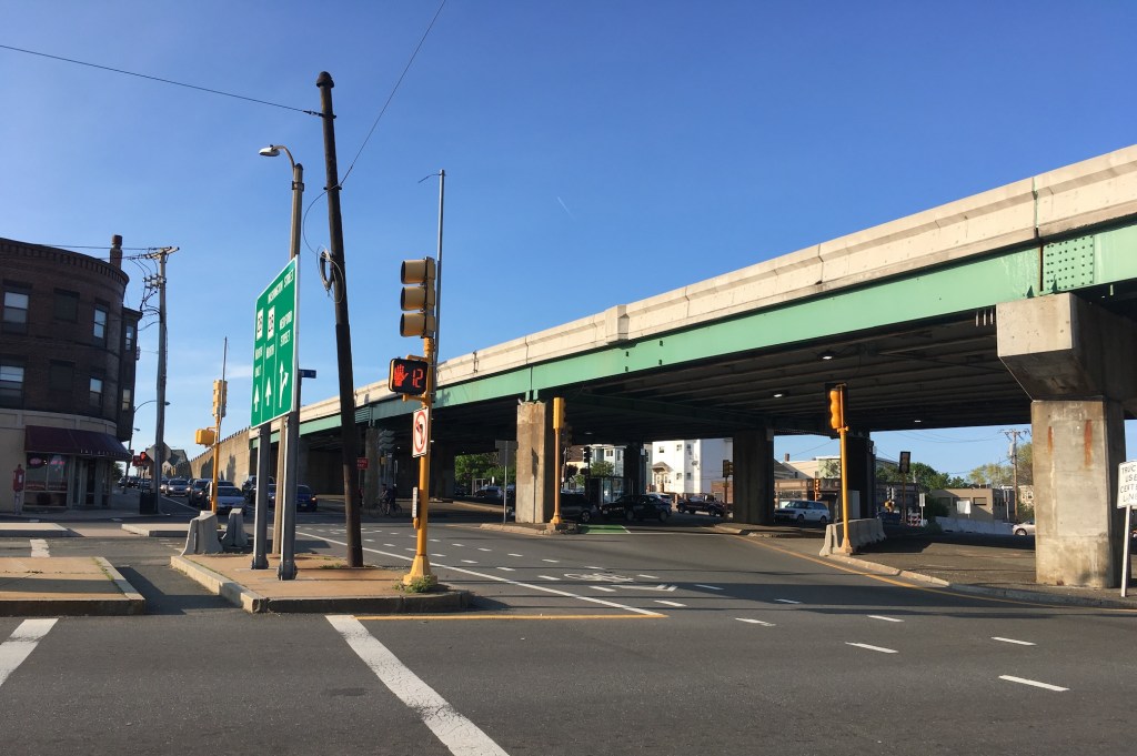
Boston University is joining a growing chorus of business organizations and advocacy groups in calling for an “at-grade” alternative in response to MassDOT’s latest proposal to rebuild the massive, eight-lane-wide Turnpike viaduct along Allston’s riverfront.
MassDOT, which has so far insisted on preserving all 12 lanes of highway traffic through the area in spite of local and statewide climate change and traffic reduction goals, has previously argued that there’s simply not enough space along the riverbank to fit all those lanes without encroachments on the Charles River.
Related:
The New Allston Turnpike Plan Looks A Lot Like the 1965 Allston Turnpike Plan
But in an online event last Friday, business organization A Better City, along with several local architects, presented detailed plans for how the project could work without a viaduct.
Glen Berkowitz, a project manager for A Better City and a participant in the Commonwealth’s Allston I-90 project task force, argued that minor changes to lane widths on the roadways could squeeze extra space for a preserved, living riverbank along the Charles River. For instance, MassDOT’s current proposals call for widening Soldiers Field Road with 11-foot travel lanes, even though the existing roadway has 10-foot lanes.
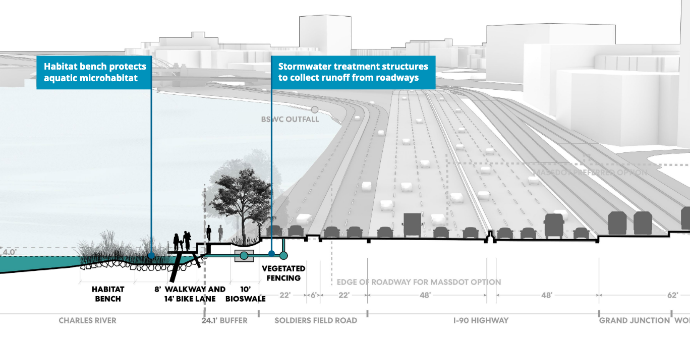
A Better City also suggested that the Paul Dudley White bike and pedestrian pathways could be cantilvered above the living riverbank, or above Soldiers Field Road, for roughly 100 yards along the so-called “throat” section, the project’s biggest pinch point.
“The major victory in this new (at-grade) design is that for the first time in the history of this project, MassDOT is showing a new riverbank that takes up extra width in the alignment,” said Berkowitz. “Under this option, a living shoreline will be made.”
The at-grade proposal also got a major endorsement last week from Boston University, which offered some additional campus land in the area to provide extra space for the project in the throat section.
Related:
A Rough Guide To Boston’s Allston/I-90 Megaproject
“I am taking the opportunity to clearly express Boston University’s preference for the ABC/City of Boston at-grade alternative,” wrote Boston University President Robert A. Brown in an Oct. 2 letter to MassDOT Secretary Stephanie Pollack. “We believe that this option confers more project benefits and reduces or minimizes more disadvantages than those associated with other options under consideration.”
The letter continues:
“In order to minimize any permanent or temporary river impacts on the north edge of the project area, Boston University is willing to make available our abutting property on the southern side of the project area to the extent that the necessary encroachments do not limit our ability to use and operate the buildings on this portion of our campus. In an area where feet, and perhaps inches, may be the difference between a workable and an unworkable solution, Boston University is committed to doing the utmost to accommodate these infrastructure improvements.”
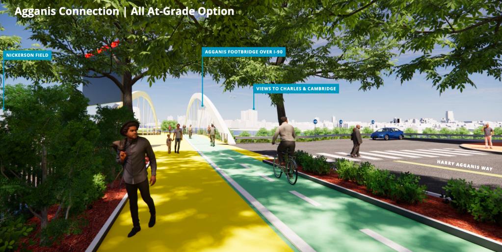
During Friday’s presentation, architects shared renderings to illustrate how much the at-grade option would benefit the Boston University campus, which lies just uphill from the highways and riverbank.
While MassDOT’s proposed viaduct would continue to block views and access to the riverfront, and put Turnpike traffic at the same level as the campus, the at-grade option would allow for the possibility of a signature bike and pedestrian bridge between Agannis Way and new Charles River parkland (see the rendering at the top of this post).
Devanshi Purohit, a Senior Urban Designer at CBT Architects, said that the at-grade option would provide more opportunities to elevate paths and parkland above the highways, and provide signature vistas of the city and riverfront.
“There is an opportunity to create an overlook – your Instagram moment – where people would go and just enjoy the river and experience the city skyline from a different point of view,” said Purohit.
MassDOT is continuing its environmental analysis of three alternatives (the “at-grade” option, an option with Soldiers Field Road elevated on a viaduct over the Turnpike, and the Turnpike viaduct option) and is expected to select a preferred alternative in the coming months.

Streetsblog has migrated to a new comment system. New commenters can register directly in the comments section of any article. Returning commenters: your previous comments and display name have been preserved, but you'll need to reclaim your account by clicking "Forgot your password?" on the sign-in form, entering your email, and following the verification link to set a new password — this is required because passwords could not be carried over during the migration. For questions, contact tips@streetsblog.org.