City of Boston Proposes Safety Improvements for Mattapan Square
On Tuesday evening, planners from the Boston Transportation Department shared conceptual designs for improved sidewalks, crosswalks, and bike lanes through Mattapan Square, which could be implemented as part of the city’s proposed Blue Hill Avenue bus priority project.
Mattapan Square is the southern terminus of the 28 bus line, New England’s busiest bus route, and the western terminus of the Mattapan streetcar line.
It’s also a complex and crash-prone intersection involving three busy roadways: Blue Hill Avenue, River Street, and Cummins Highway.
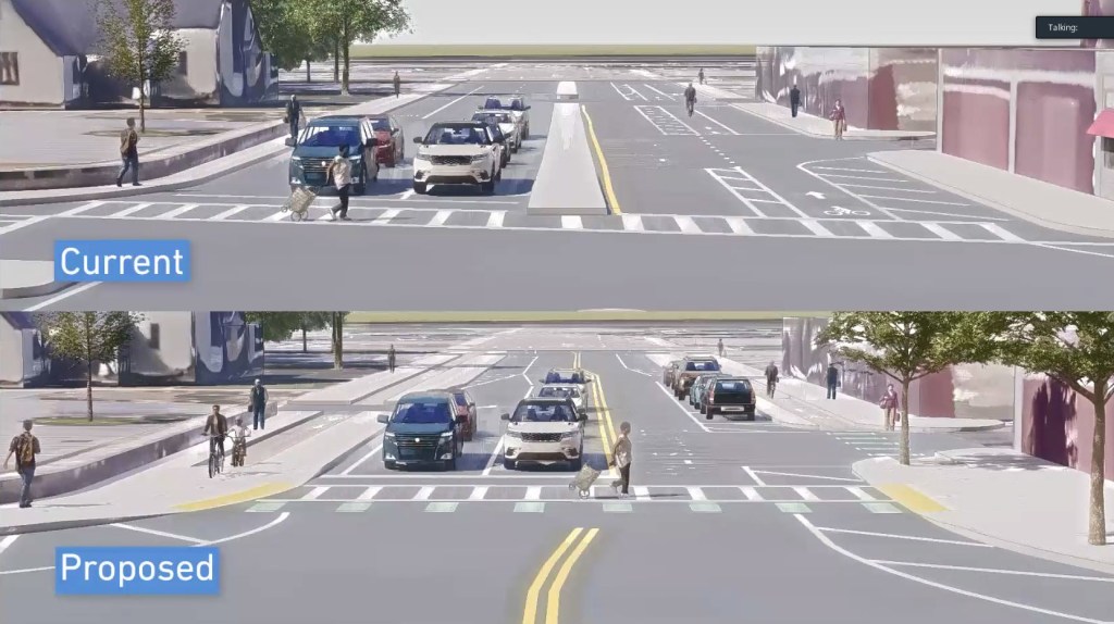
To improve safety – particularly for the thousands of transit riders who pass through the square – the City of Boston’s Transportation Department is proposing to close the wide right-turn slip lane in front of the Mattapan trolley terminal, widen sidewalks to reduce crosswalk distances, and add a new crosswalk across the Blue Hills Parkway to provide more direct access to the T station and the Neponset Greenway from the neighborhoods to the west:
The design would incorporate proposed center-running bus lanes on Blue Hill Avenue, which would connect directly to the T station. Southbound buses currently access the station by continuing south into Milton, then making a u-turn, so this design is also expected to speed up trips on the 28.
The city’s proposal would also mesh with other safety improvements that are being proposed for the length of Cummins Highway in a future construction project.
During a question-and-answer session after the city’s presentation, there were some residents who expressed distrust with the city’s plans for Blue Hill Avenue, and others who raised concerns that by widening sidewalks, the city would constrict traffic flow for motor vehicles.
But a number of residents who get around on transit or on foot expressed appreciation for the city’s efforts to improve safety.
Mattapan resident Gael Henville, who said that she frequently runs on the Neponset Greenway, told the planners that “I see this as an improvement… There are many of us out walking, which is why I love Mattapan, coming from the Caribbean. And it is a safety issue: unless I jaywalk, sometimes I am standing for three minutes crossing from crosswalk to crosswalk.”
“I’m not a driver. I’m a pedestrian, and I take the T,” said Jessie Dambreville. “That intersection is a death trap. So I am very happy with the changes that you’re proposing, because it’s really scary for me to get to the train station, or to get to the greenway, or getting even to Mattapan Square.”
BTD planner Charlotte Fleetwood told participants that “we absolutely want to make sure it’s safe for all users, but especially for those transit users, who at peak hours make up more than 50 percent of the people on Blue Hill Avenue… so that’s a critical element of all of this.”
Tuesday’s virtual public meeting on Mattapan Square was one of many that the City of Boston expects to host over the next year as it refines its plans for the entire length of Blue Hill Avenue. According to a timeline in the city’s presentation, the city expects to spend all of 2022 and part of 2023 conducting community outreach before completing designs, and construction could begin in 2024.

Read More:
Streetsblog has migrated to a new comment system. New commenters can register directly in the comments section of any article. Returning commenters: your previous comments and display name have been preserved, but you'll need to reclaim your account by clicking "Forgot your password?" on the sign-in form, entering your email, and following the verification link to set a new password — this is required because passwords could not be carried over during the migration. For questions, contact tips@streetsblog.org.