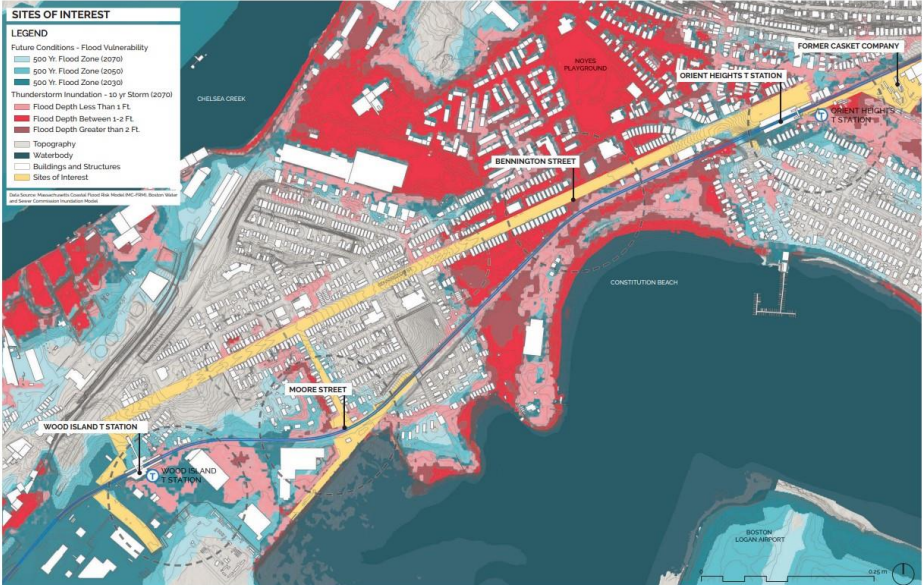
The community of East Boston has been dealing with climate change on many fronts. As one of the five “Environmental Justice” neighborhoods highlighted in the City of Boston’s recent Heat Plan, it is not only disproportionately affected during high heat events, but its geography also makes it prone to flooding from rising sea levels.
This summer, Stone Living Lab awarded A Better City, a Boston-based business organization, a $50,000 grant set to focus in East Boston to study the effects climate mitigation efforts can have on both physical infrastructure like transportation, and the communities' socio-economic infrastructure, a combination that is often missed in climate studies.
Climate change risks such as high heat events can take a toll on transportation infrastructure such as train tracks, as we saw this summer in Boston after a couple of heat waves prompted the MBTA to roll out speed restrictions on parts of the subway system.
As one of the few ways people can access Boston proper from East Boston without a car, the Blue Line is a critical transportation corridor that's vulnerable to climate-related impacts and also to socio-economic pressures like gentrification.
During the pandemic, stations along the Blue Line were among the T stations showing high rider retention as essential workers from East Boston used the subway line to reach their jobs across the harbor.
Portions of this transportation corridor also run near Route 1A, an expressway currently being studied by MassDOT, in an effort to “improve connections to the local and regional roadway network, enhance transit, improve bicycle and pedestrian connections, and mitigate climate change impacts,” according to the agency’s scope of work document released in 2020.
Additionally, the study aims to explore, “the potential uses of the MassDOT and MBTA rail parcels located between Route 1A and the Chelsea Creek in East Boston.”

StreetsblogMASS spoke with Kate Dineen, Executive Vice President of A Better City, and Paul Kirshen, Stone Living Lab's Research Director, about the project they hope to undertake with this grant.
The project, Greening the Blue Line, a collaboration between ABC, Civic Space Collaborative, and Weston and Sampson, will be evaluating the potential for nature based solutions to protect critical transportation infrastructure from coastal and stormwater flooding, and uplift communities along the Blue Line and East Boston, according to Dineen.
“We've gotten together because the (City of Boston), but also the region is very interested in using what we call nature based solutions to manage present increased coastal flooding. A nature based solution is actually an engineered structure, a project that mimics the performance of nature in providing protection against coastal flooding,” explained Kirshen.
Climate change efforts involving nature based solutions have been catching on in the Boston area.
The Emerald Tutu is a Northeastern University project aimed to protect our coast from rising sea levels through a buffer-like network of floating vegetation mats. Kirshen says both groups know about each other and are in communication as part of a larger group exchanging knowledge about nature based solutions.
On top of the mitigation effects nature based solutions can have, they can also provide what Kirshen and Dineen refer to as “co-benefits.” Kirshen offered the example of a berm or wall which can offer habitat on the coastal side – providing ecosystem benefits – and open space on the urban side – providing social benefits for residents.
In East Boston, Bremen Street Community Park and East Boston Memorial Park are among the few open green spaces available to residents of this community.
“There's a huge environmental justice component to these nature based systems,” says Kirshen.
Dineen cited statistics from the City of Boston’s ongoing neighborhood plan, Plan East Boston, which she says helped guide the team's efforts:
- 22% population growth from 2000 to 2017
- 55% Spanish speaking population
- 58% of the land area vulnerable to flooding by the 2070s
- 80% of the MBTA Blue Line stations are at risk
- 1.3% annual growth rate for boardings in East Boston at the MBTA Blue Line stations.
“How do (nature based solutions) improve the health and vibrancy of communities and commercial districts by creating new recreational opportunities? How do they help mitigate other impacts of climate beyond flooding, like extreme heat?” she asked.
The team is primarily focusing on two stations along the Blue Line: Wood Island and Orient Heights. At the end of the project, the team will share conceptual design approaches such as sketches and renderings for nature based solutions that could be implemented in key areas near these stations to help mitigate coastal flooding.
One challenge for the project is gathering input from a diverse array of voices, which Dineen says is very important to the team.
“We're trying to think really creatively about how we work with our community based organization partners, elected officials and government stakeholders to make sure we're not just talking to the same old folks who get engaged in previous planning processes,“ she said.
Beyond their meetings, the team has conducted English and Spanish surveys and plans to host resident focus groups through the fall.
The final report is expected in February of next year.


