New Wayfinding Guide Aims to Help Riders Find Their Way Across the Commonwealth

If you’ve ever found yourself bewildered on Boylston Street, lost in Lowell, or stranded in Sandwich, the state has a new plan to help you get your bearings on your bike rides.
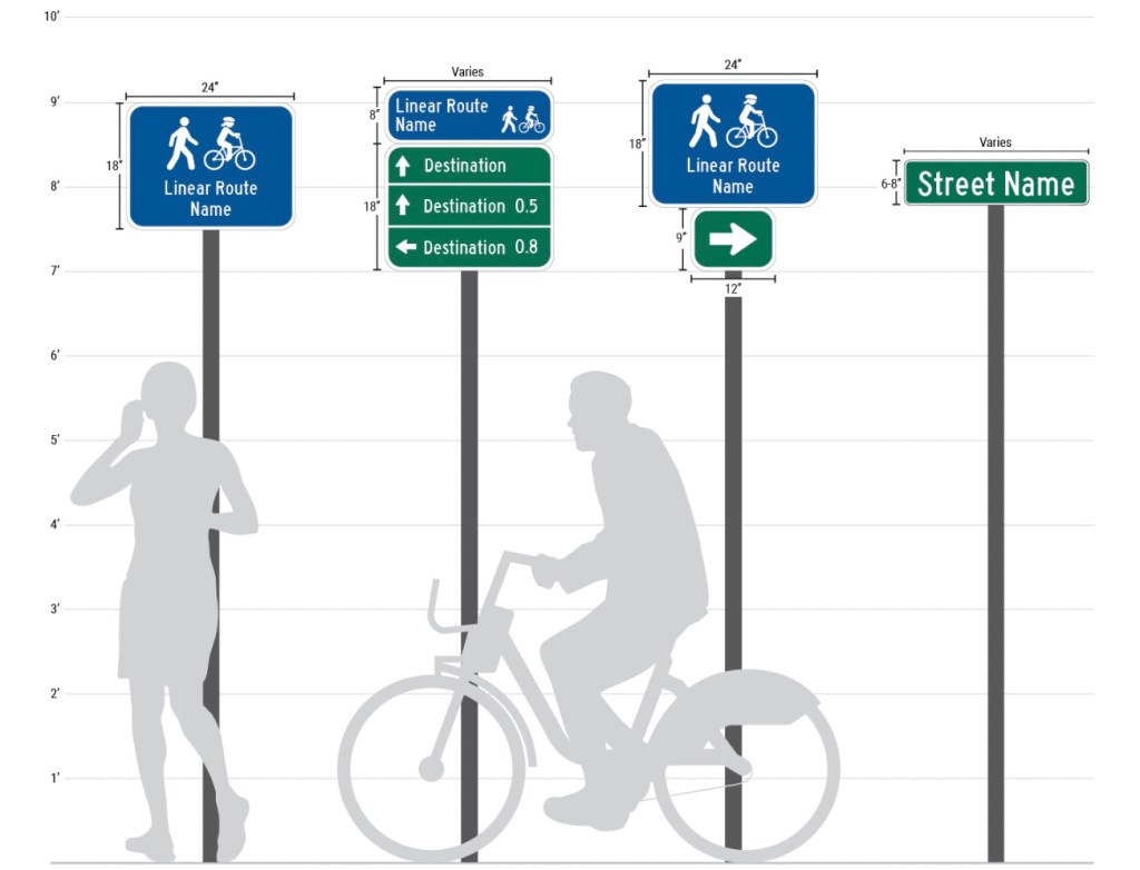
The new Bike Wayfinding Design Guide from the state’s inter-agency MassTrails team establishes a system of consistent, easy-to-read signage for bike routes and multi-use pathways.
The guide includes standards for how signs along bike routes should look, where and how they should be installed, and what information they should include.
“The point of the wayfinding guide… (is) to get more people on bikes and make it easier to bike around the commonwealth. Wayfinding is a big part of that,” said Kayla Sousa, Senior Program Manager for MassDOT’s Highway Division, at the virtual meeting of the Massachusetts Bicycle and Pedestrian Advisory Board earlier this week.
The design guidelines are already being put to use in a project that will add and replace older signage for the Claire Saltonstall Memorial Bikeway, a bike route that traverses the length of Cape Cod from Provincetown to Bourne to Woods Hole.

The Claire Saltonstall Memorial Bikeway was originally established in 1978, and its route overlaps with the longer East Coast Greenway, as well as with shorter paths like the Cape Cod Rail Trail and Shining Sea Bikeway.
Many of those overlapping routes have their own signage, with varying degrees of legibility and usefulness.
“When you have a bike route around for close to 50 years, there’s lots of existing signage. A lot,” said Sousa.
Some of Cape Cod’s bike route signage is outdated – pointing to older on-street routes when a newer, safer off-street route is available, for instance. And there are many examples of signs that are hard to see, or difficult to understand.
The Cape Cod Commission will replace dozens of existing wayfinding signs along the Claire Saltonstall Memorial Bikeway and revise the route to guide users onto the best available infrastructure.
The Cape Cod project will “serve as kind of the pilot example of this design guide,” said Sousa.
In the Boston region, with its peculiar street grids, history of demolishing park lands for highways, and universities that bring in thousands of geographically naive car-free residents every September, the lack of wayfinding signage on local bike routes and multi-use pathways sometimes lead people on bikes into places they’d rather not be:
This kind of wayfinding is something that people in cars on state-owned roadways can take for granted.
But because planning, siting, and installing new signs takes a considerable amount of work, it will likely take many years for the state’s emerging network of multi-use paths and on-street bike routes to meet the standards outlined in the new design guide.
Still, its sponsors at MassTrails are encouraging that other groups – including municipal governments and even nonprofit trails advocacy groups – to use the Design Guide to design and install more signage along bike routes without the state’s direct involvement.

Read More:
Streetsblog has migrated to a new comment system. New commenters can register directly in the comments section of any article. Returning commenters: your previous comments and display name have been preserved, but you'll need to reclaim your account by clicking "Forgot your password?" on the sign-in form, entering your email, and following the verification link to set a new password — this is required because passwords could not be carried over during the migration. For questions, contact tips@streetsblog.org.