A Common Story: Traffic Engineers Pit Safety Improvements Against Parking In Woburn Center Project
Preliminary designs for a redesign of streets around Woburn’s town center aim to improve safety in a crash-prone area, but project designers are also offering an alternative scheme that would remove proposed bike lanes along Main Street to preserve 16 on-street parking spaces.
The proposed project, which has a $19 million budget and is tentatively scheduled for construction in 2029, would redesign three streets that converge around the town common in Woburn’s downtown: Main Street (also known as State Route 38), Pleasant Street, and Montvale Avenue.
Those streets today converge at Woburn Common, where vehicular traffic merges together in a multi-lane, one-way rotary.
The existing traffic pattern forces many drivers to drive out of their way in a circle around the common through multiple intersections. The vortex of traffic frequently causes gridlock, even when most of the multiple-lane roadways remain empty, as seen in the drone video below.
This junction also ranks among the state’s 200 worst intersections for crashes. With numerous crosswalks that traverse mutli-lane roadways – a design that exposes pedestrians to considerably higher risks in drivers’ blind spots – it’s also among the Commonwealth’s worst places for pedestrian crashes in particular.
“I don’t have to tell you, it’s not a very safe place to navigate,” said Richard Benevento, a senior vice president for project consultants Tighe and Bond, during a May public hearing for the project.
The biggest change that Benevento and his colleagues are proposing would be to eliminate the rotary and convert Main and Pleasant Streets back into more ordinary two-way streets, with traffic signals at intersections.
The project would also rebuild sidewalks, curb extensions, and curb ramps to make Woburn’s downtown completely accessible to Americans With Disabilities Act standards.
Main St. bike lanes might be sacrificed for 16 parking spots
In initial plans that Tighe & Bond presented at a September 2024 public hearing, the project would have painted bike lanes and a cross-hatched buffer zone on both sides of Main and Pleasant Streets through most of the project area.
The project is receiving state funding, and MassDOT’s design standards generally require buffered or physically-protected bike lanes in high-traffic areas.
But when consultants from Tighe & Bond returned for a second public hearing this May, they presented a new alternative design that eliminated proposed bike lanes on Main Street in favor of 16 more on-street parking spots.
“The second alternative maintains parking on both sides (of Main Street). Once we do that, there isn’t enough room left to provide bicycle lanes. So we end up with 14-foot-wide ‘shared’ lanes,” explained Greg Lucas, a traffic engineer for Tighe & Bond.
According to the presentation the consultants delivered at the May public hearing, there are currently over 860 parking spaces in downtown Woburn, with over 700 spaces located in massive off-street parking lots along Main and Pleasant Streets.
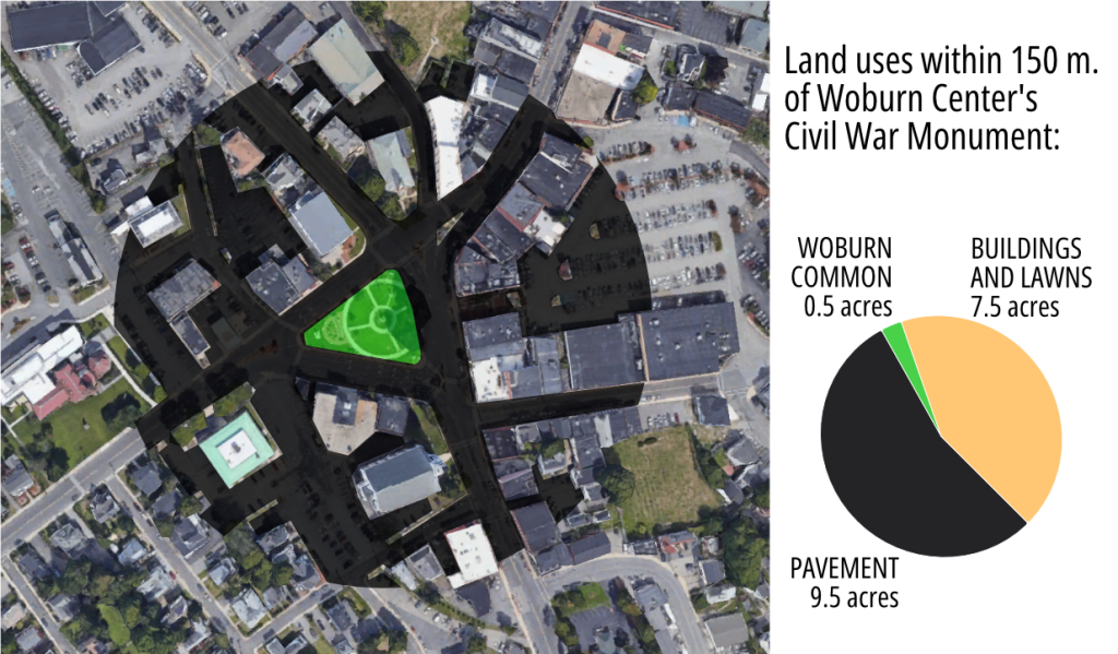
In the core of Woburn’s downtown area around the town common, considerably more land is devoted to asphalt parking and driveways than to buildings (see the figure at the top of this story).
The consultants also surveyed the utilization of downtown Woburn’s parking areas during the midday and evening hours, and found that there were hundreds of empty spaces available even at peak hours.
On-street parking along Main and Pleasant Streets accounts for a fairly small portion of that space: there are presently about 130 on-street parking spots, or about 15 percent of the area’s total.
The consultants from Tighe & Bond did not mention it in their presentation, but their new alternative would likely run afoul of MassDOT’s street safety design requirements, and force the town to conduct additional work through a “design exception” appeals process before they receive state funding.
Residents ask for safety to be the priority
After their presentation, the project team took questions from an audience of roughly a dozen residents.
Woburn resident John Heslin told the project team “I’m not a cyclist, but I suspect the reason we don’t have cyclists downtown now is because they don’t have a death wish.”
“I understand about the parking downtown and I share those concerns, but the second option – we don’t share the road well. So I guess I’m not completely clear on what a ‘shared road’ is for the cyclists and the drivers. To me, it probably clicks a box, but it doesn’t actually help anyone who wants to cycle through downtown, so I’m somewhat skeptical.”
Woburn Center resident Sascha Hernandez acknowledged the need to support local businesses with some on-street parking, but also expressed a desire for the project to create more vibrant, active public spaces around the town common.
“It’s a shame to put so much parking on Common Street when it could become part of our public space in Woburn,” said Hernandez.
“I’d like to think that if Woburn Center were a safer place to walk around, then people wouldn’t mind walking a little further from their parking space to the restaurants downtown,” observed Talya Moked, another nearby resident.
Hernandez also urged project designers to put a stronger focus on slowing down traffic.
“The town put up these ‘yield to pedestrian’ signs in the road. Which are great,” observed Hernandez. “And then they promptly got run over, and then removed. And they haven’t been there for months. Which tells you about the behavior of drivers in this area.”

Read More:
Streetsblog has migrated to a new comment system. New commenters can register directly in the comments section of any article. Returning commenters: your previous comments and display name have been preserved, but you'll need to reclaim your account by clicking "Forgot your password?" on the sign-in form, entering your email, and following the verification link to set a new password — this is required because passwords could not be carried over during the migration. For questions, contact tips@streetsblog.org.