MassDOT and the Town of Tisbury Make Plans to Address Climate Change, Crashes, and Connectivity on Martha’s Vineyard
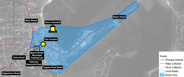
On Martha’s Vineyard, MassDOT is collaborating with the Town of Tisbury to address safety problems as well as increasing flood risks from sea level rise around Beach Road and the Five Corners intersection in the center of Vineyard Haven.
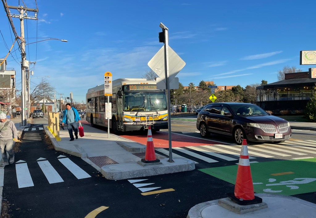
Five Corners in Tisbury is a major intersection connecting Water Street, Beach Street Extension, Beach Road, Lagoon Pond Road, and Beach Street, two blocks away from the ferry terminal to mainland Massachusetts, and a short walk away from the town’s local beaches and Main Street businesses.
The intersection carries multiple challenges: it’s a hot spot for crashes, and it also floods on a regular basis.
While projects have been put into place to address flooding concerns, road safety, and multimodal accessibility, growing concerns about the future impacts of climate change and how to adapt to them remain.
Since 2023, MassDOT has been working with town officials and a local working group of stakeholders on a planning study for Beach Road and the Five Corners intersection, and this summer, the group issued a report with its recommendations.
The Issues
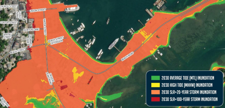
Flood Vulnerability
Currently, the area around Five Corners is a “shallow, funnel-shaped” lowland with elevation ranging from under 2 feet to 4 feet elevation, which puts it at risk to rising sea levels and storm impacts.
Five Corners in particular is around 2.5 feet above sea level. Water often pools there when it rains, and a neighborhood storm drainage pipe that runs under the Beach Street Extension is often blocked by debris or incoming tides.
The Massachusetts Coast Flood Risk Model analyzed the flood risk for the area come 2030, and found that the sea level is projected to rise at an average of 1.2 feet, with highest tides reaching 2.4 feet above the current sea level. By 2050, Five Corners could be flooded almost daily.
Road Safety
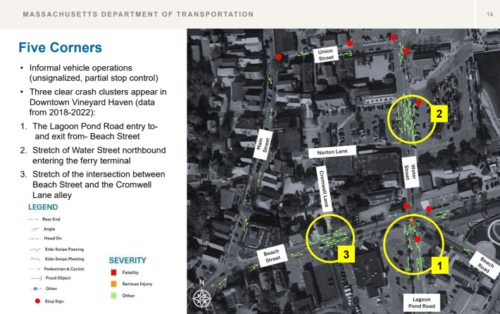
The area has also seen difficulties in road safety, with 82 crashes occurring between 2018 and 2022. MassDOT reported several factors contributing to the crashes: “distraction, inattention; failure to yield the right-of-way; failure to keep in the proper lane; following too closely; disregarding traffic signs, signals, and road markings; over-steering; visual obstructions to view; reckless driving; and physical impairment.”
Emergency Services
Flooding in Five Corners isn’t just an inconvenience: it also blocks an important emergency services route for the island.
EMS services in the area regularly use Beach Road through Five Corners to access Martha’s Vineyard Hospital. It’s also a critical link in, the island emergency evacuation route, and power line maintenance to restore power during and after storms also takes place through this area.
The Hospital Resilience Project, which took place between 2023 and 2024, assessed EMS operations and potential impacts from flooding over the next 50 years, and determined that Five Corners and Beach Road were high priority areas to allow for continued access to the hospital.
Multimodal Accessibility
For pedestrians, there are sidewalks throughout Five Corners. However, many are narrow with obstructions like utility poles and fire hydrants that violate Americans with Disabilities Act (ADA) standards.
The area is also a gap in the island’s otherwise extensive network of separated shared-use pathways.
The Solutions
The Martha’s Vineyard Road Study in Five Corners recommends a range of short-term alternatives, like repainting crosswalks and installing signs for visibility, realigning crosswalks to be perpendicular with the street, and installing ramps and tactile strips at all crosswalks.
Medium-term alternatives include taking Water Street down to two travel lanes from three in order to make space for a shared-use path on the west side of the street, plus the addition of a shared use path on the south side of Main Street to connect to Five Corners.
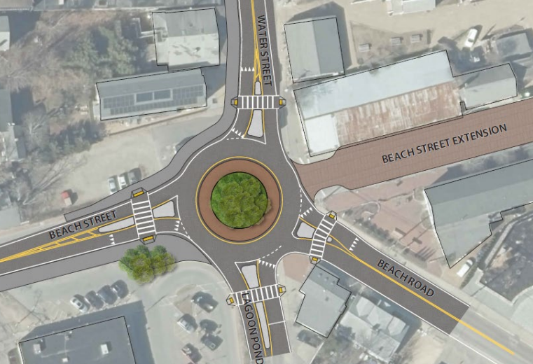
Addressing the area’s flooding issues will be a longer-term project. The study recommends raising the entire intersection and possibly reconfiguring the junction as a roundabout. While elevating the intersection by 5 feet is presented as a potential option in the study, research finds that even a 5 foot elevation change at Five Corners would be insufficient to address recurrent flooding beyond the year 2030 – leaving discussions of elevating the intersection and its right-of-way impacts to be further evaluated and discussed with stakeholders as the project develops. Planners also recommend creating a new bi-directional shared-use path on the south side of Beach Street and Beach Road to connect Vineyard Haven to Oaks Bluff, and a new sidewalk on the west side of Lagoon Pond Road.
Several studies support the proposed design alternatives, from the Tisbury Drainage Master Plan, to the Dukes County Multi-Jurisdictional Hazard Mitigation Plan, to the Martha’s Vineyard Hospital Resilience Plan, to the Town of Tisbury Alternatives Analysis for Vineyard Haven.
Over the course of the last two years, the community has convened in public meetings and working group meetings to put these plans into motion, the most recent of the former being in May and the latter in June.
During May’s Working Group Meeting, participant Ben Robinson noted that the Beach Street Extension already functions as a slow-traffic, shared space for pedestrians and cyclists.
“I think raising it to differentiate it from Five Corners, sort of making it four corners instead of Five Corners, there’s something there,” he said.
James Houle, another May meeting participant, stressed the urgency of tackling existing flooding.
“The immediate problem, I think, is really unavoidable, and that’s the flooding that occurs even with as little as half an inch of rain that jams up the primary way to the hospital and the primary exit route off the island,” said Houle.
He shared his perspective in that any immediate actions should fit into a long-term plan for the area so that the “short-term mitigation efforts merge into the midterm and long term.”
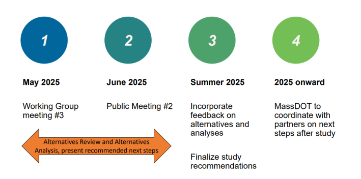
At this point, the project team is incorporating public feedback in order to finalize their study recommendations, after which MassDOT will coordinate with project partners on the next steps.
In order to stay connected to and informed on this project, visit the MassDOT website.

Streetsblog has migrated to a new comment system. New commenters can register directly in the comments section of any article. Returning commenters: your previous comments and display name have been preserved, but you'll need to reclaim your account by clicking "Forgot your password?" on the sign-in form, entering your email, and following the verification link to set a new password — this is required because passwords could not be carried over during the migration. For questions, contact tips@streetsblog.org.