Town of Arlington Considers Quick-Build Improvements to Deadly Mass. Ave. Intersection
The Town of Arlington is considering a quick-build project to calm traffic at the intersection of Massachusetts Avenue and Appleton Street in Arlington, where a motorist struck and killed Charles Proctor in a head-on crash last May.
After last summer’s fatal crash, the town’s Select Board convened a new design review committee “to study and make recommendations for both short term and long term improvements to the intersection of Massachusetts Avenue and Appleton Street.”
That committee is scheduled to meet next Tuesday, March 23 to consider two short-term improvement projects that could be implemented relatively quickly.
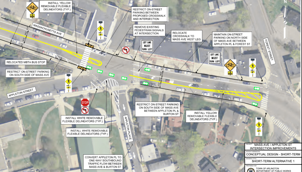
Both alternatives would make Appleton Place a one-way street, remove the intersection’s aging traffic signals to replace them with flashing yellow beacons at crosswalks, and separate Appleton Place and the adjacent Appleton Street with a painted curb extension delineated with flexposts.
Both alternatives would also create a painted, flexpost-delineated median island on Mass. Ave. in the vicinity of the intersection, although the median in Alternative 1 would be smaller to make room for a dedicated left-turn lane:
Higher-resolution plans for alternative one and alternative two have been posted to the town’s website.
In a phone conversation with Streetsblog on Monday, Daniel Amstutz, Arlington’s Senior Transportation Planner, said that the short-term improvements could be implemented “this spring or summer, depending on what kind of costs we might be looking at… It is a priority for the town.”
The intersection has long been recognized as a threat to Arlington residents’ physical safety. In 2011 and 2012, the Boston Region Metropolitan Planning Organization, citing “the relatively high number of crashes at this intersection and students’ safe access to Ottoson Middle School,” conducted a detailed study of the same intersection and recommended a reconfiguration that would have simplified traffic patterns and shortened the intersection’s crosswalks.
But those recommendations were never implemented.
Amstutz added that the town also wants to move forward with some short-term crosswalk improvements to Chestnut Street, where an SUV driver struck and killed an 81-year-old woman in 2019. A public hearing on that project is expected to be held later this month.
Meeting information:
Mass. Ave./Appleton Street Design Review Committee
Tuesday, March 23, 2021, 7:00 PM – 8:00 PM
Pre-register for this Zoom meeting at https://town-arlington-ma-us.zoom.us/meeting/register/tJYlcO2hpjgtHtZe5Mb4-bRBcJ98KGj5fZgV

Read More:
Streetsblog has migrated to a new comment system. New commenters can register directly in the comments section of any article. Returning commenters: your previous comments and display name have been preserved, but you'll need to reclaim your account by clicking "Forgot your password?" on the sign-in form, entering your email, and following the verification link to set a new password — this is required because passwords could not be carried over during the migration. For questions, contact tips@streetsblog.org.