DCR Will Make One of Its Pointless Charles River Highways Half As Pointless
The Commonwealth’s Department of Conservation and Recreation (DCR), the state’s parks agency, is moving ahead with plans to renovate a portion of the Leo Birmingham Parkway in Brighton with a smaller footprint and a new shared-use pathway.
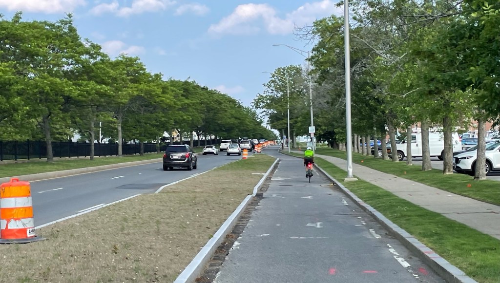
Birmingham Parkway (pictured above) is currently a four- to six-lane highway that runs parallel to between three other highways along the banks of the Charles River.
It currently has no sidewalks for most of its length. And its two existing crosswalks are at either end of the highway, a full kilometer apart from each other.
Under the DCR’s plans, the highway’s width would be cut in half, replacing a divided four-lane highway with a 30-foot-wide, two-lane city street, with a new 12-foot-wide shared-use path running parallel on the north side of the roadway.
The plan would also install new traffic signals at the intersections of Beacon Street and Market/Lincoln Street.
According to a public hearing the DCR hosted in February, the agency hopes to finalize the project’s construction blueprint in the next few months and have the project ready to go to bid for construction this summer.

A bypass of a bypass
The Charles River is notoriously choked with DCR-owned riverfront highways of dubious utility.
But this section of the riverfront in Brighton is an especially egregious example of the agency’s century-long campaign to pave the Commonwealth’s riverfront parkland.
Along this one-mile stretch of the Charles River, DCR maintains the 4-lane Soldiers Field Road, the 4- to 6-lane Arsenal Street, and the 2- to 3-lane Greenough Boulevard.
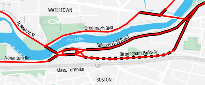
And all of those DCR-controlled highways run parallel to the 8-lane Massachusetts Turnpike.
That Birmingham Parkway exists at all turns out to be a historic fluke. According to the National Register of Historic Places entry for the Charles River Reservation,
While the (Metropolitan Parks Commission) and its successor after 1919, the Metropolitan District Commission (MDC), acquired as much land as it could along the river banks, in some cases land was not available. Such was the case with the Brighton Abbatoir (slaughterhouse) located just west of Market Street along the southern edge of the river. Since a river parkway was not feasible initially in that section, the MDC routed the parkway a short distance to the south of the river. This segment, completed in 1936, was known as Leo Birmingham Parkway. Ironically it was only a few years later, in the 1940s, that the abbatoir closed and the MDC was able to acquire land along the river, allowing the extension of Soldiers Field Road from Arsenal Street to North Beacon Street.
National Park Service, National Register of Historic Places
The opening of the Massachusetts Turnpike in the late 1950s made the Birmingham Parkway even more redundant for motor vehicle traffic.
DCR Parkways Plan suggested eliminating the road altogether
In the DCR’s official Parkways Master Plan, published in 2021, the agency confirmed that “regional traffic demand is served by adjacent corridors” and suggested that future plans for the highway should investigate the possibility of getting rid the road completely.
“The parkway can be restored to parkland with through access for
non-motorized users,” according to the Parkways Master Plan. “Recreational facilities could be added, such as playing fields, skate park, or an open-air restaurant.”
If the DCR had pursued that recommendation, an additional 2 acres could be available for new recreational facilities and greenery.
On Monday, StreetsblogMASS reached out to the DCR to understand why they decided to use the state’s tax dollars to re-bury the parkland under 2 acres of asphalt instead.
We’ve also asked DCR how much it plans to spend on the new roadway project.
This story will be updated if we hear a response.

Read More:
Streetsblog has migrated to a new comment system. New commenters can register directly in the comments section of any article. Returning commenters: your previous comments and display name have been preserved, but you'll need to reclaim your account by clicking "Forgot your password?" on the sign-in form, entering your email, and following the verification link to set a new password — this is required because passwords could not be carried over during the migration. For questions, contact tips@streetsblog.org.