DCR Proposes A Six-Lane Riverfront Highway For Its Brighton ‘Park’
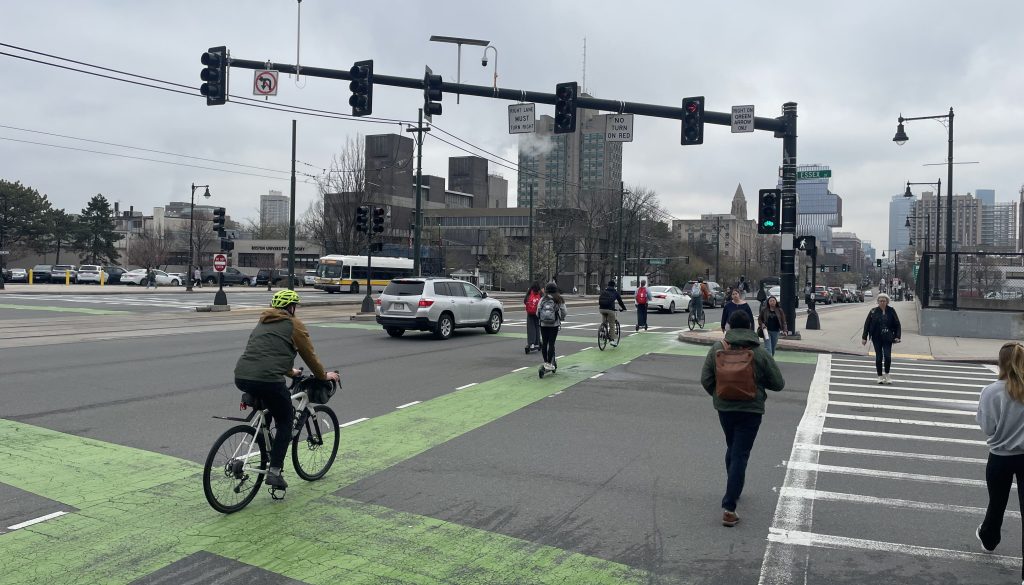
Last Thursday, officials from the Department of Conservation and Recreation (DCR) and their consultants from the Pare Corporation heard an earful from Allston and Brighton residents who were unimpressed with their proposal to build a new 6-lane-wide highway (pictured above) in the middle of their neighborhood’s riverfront park.
The proposed roadway would replace a poorly-designed rotary where North Beacon Street, Nonantum Road, and Soldiers Field Road all converge on the banks of the Charles River.
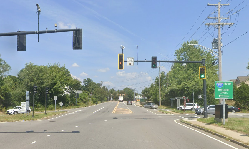
The latest design updates a concept from a 2021 study of the area, in which consultants analyzed various potential reconfigurations of the intersections, including replacing the entire rotary with a connected pair of roundabouts or signalized intersections (pictured below).

In an online meeting last week, officials from DCR and consultants from the Pare Corporation presented a bulked-up version of that 2021 concept with more lanes, wider intersections, and longer, more dangerous crosswalks.
Derek Hug, an engineering consultant from the Pare Corporation, explained that the desire to accommodate commuter car traffic trumped the desire to provide more unpaved parkland and safer pedestrian crossings.
The goal “is to improve pedestrian connectivity, while making sure that we provide enough (lane capacity) to make sure that this doesn’t degrade into gridlock, given the proximity of these two very heavy intersections to each other,” said Hug. “Putting signals in does not have nearly the same throughput as a circulator (rotary).”
“The overwhelmingly heaviest movement is between Nonantum Road and Soldiers Field Road. And so we had to work that into our design. That certainly made these (capacity) analyses a little bit more tricky.”
The DCR maintains numerous riverfront highways in the Boston region that exacerbate the region’s air pollution and congestion by subsidizing suburban car commuters to drive into downtown Boston.
These roadways rank among the region’s worst sources of climate-heating greenhouse gases and other noxious air and water pollutants.
Parkland vs. traffic
Matthew Petersen, a transportation planner for the City of Boston, observed that the Pare Corporation and DCR were proposing “an extremely wide and very broad cross-section.”
“Replacing the current layout with this does seem to trade one kind of barrier (to the river) for another. And on all roads with more than one lane in each direction, you do have a much worse safety profile with every additional lane, even with a signalized crossing. So it does give us some pause,” said Petersen.
The super-sized roadway proposal is at odds with other recent DCR projects in the area.
In 2012, the agency redesigned Nonantum Road, formerly a four-lane undivided highway, as a two-lane street (however, the project did not change the short five-lane segment between Brooks Road and the rotary).
The DCR has also recently started work to tear out two lanes of the nearby Birmingham Parkway, including part of North Beacon Street. That project will replace a divided four-lane highway with a two-lane city street, and build a parallel 12-foot-wide shared-use path that will run from the traffic circle to Market Street near Brighton Landing.
When that project is over, the only roadway feeding into this intersection with more than two lanes will be Soldiers Field Road – and the DCR recently recommended turning that into a two-lane street, too.
‘I’d hate there to be another death’
Doug Cornelius, the chair of the MassBike board of directors, honed in on the proposed Paul Dudley White path connection along the riverbank, next to the bridge that carries North Beacon Street over the Charles.
“It’s incredibly dangerous right now. There’s no signal; you’ve got two fast-moving lanes turning onto North Beacon Street that are not needed,” said Cornelius.
He asked DCR officials to implement some short-term traffic calming improvements while planning continues for the longer-term reconstruction project being discussed.
“I’d hate there to be another death here on a DCR property. This is a very, very dangerous intersection, with lots of kids going back and forth to CRI (Community Rowing, Inc.), which is just down the path here. I see someone get hit almost every day at this intersection, and it’s only going to be a matter of time until there’s going to be something really serious,” said Cornelius.
Other neighborhood residents expressed disappointment with the DCR for trying to facilitate more traffic instead of restoring the neighborhood’s parkland.
“We don’t believe that DCR’s mission is to provide motor vehicle transportation facilities,” said a Zoom participant named Nathan Mandell. “It’s the Department of Conservation and Recreation, it’s not MassDOT.”
The DCR is accepting public comment on the proposed design until May 8th at www.mass.gov/forms/dcr-public-comments.

Read More:
Streetsblog has migrated to a new comment system. New commenters can register directly in the comments section of any article. Returning commenters: your previous comments and display name have been preserved, but you'll need to reclaim your account by clicking "Forgot your password?" on the sign-in form, entering your email, and following the verification link to set a new password — this is required because passwords could not be carried over during the migration. For questions, contact tips@streetsblog.org.