Redesigning Route 123: Bike and Pedestrian Improvements Coming to Brockton-Abington

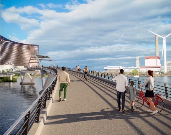
MassDOT has unveiled plans for bike and pedestrian infrastructure improvements along Route 123, the east-west roadway that links downtown Brockton and Abington.
The street is also known as Center Street in Brockton, and as Brockton Avenue in Abington.
Currently, the Route 123 corridor lacks continuous, accessible pedestrian and bicycle infrastructure, but the planned $33 million project will build new sidewalks and striped buffered bicycle lanes between Lyman Street in Brockton and Ashland Street in Abington, according to a public hearing that MassDOT hosted this summer.
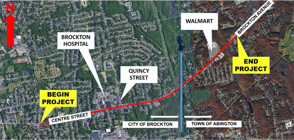
The project also proposes traffic signal improvements at the intersection of Route 123 with Quincy Street in Brockton, and a reconfiguration of the intersection of Route 123 with Martin, Mill, and Green Streets in Abington.
The 2-mile stretch of road has had a history of being unsafe for cyclists and pedestrians. The intersection at Quincy Street and Route 123 is within the top 200 crash locations in the entire state of Massachusetts.
Additionally, MassDOT considers the existing geometry of a number of intersections along the corridor as “inadequate for vehicular turning movements” – from the wide 5-way intersection at Green, Martin, and Mill Street, to a lack of left turn lanes, and poor lane alignment on Quincy Street traveling southbound.
Project details
The project was initiated at the beginning of 2020, and it wasn’t until March of 2024 that the state started designing concepts for the project.
MassDOT and Chappell Engineering have coordinated with the City of Brockton, the Town of Abington, their Public Works and Emergency Services, utility companies, and the public in order to continue refining the design to its current 25-percent design stage.
P.E. Philippe Jean-Baptiste of engineering partner Chappell Engineering presented the details of the project in a July 28 virtual meeting.
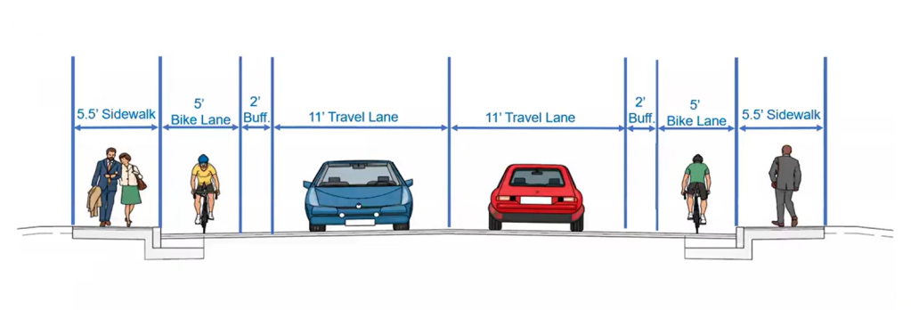
The design concept will see the construction of two 11-foot travel lanes, two 2-foot bike buffers, two 5-foot bike lanes, and again the two 5 1/2-foot sidewalks with a 6-inch vertical curb separating the sidewalk from the travel lane on either side of Route 123.
At the Quincy Street intersection, traffic signals will be replaced with more modern equipment, the intersection will be reconfigured, and construction will add crosswalks and left turn lanes.
At the 5-way intersection of Mill, Martin, and Green Street, Martin Street will be converted into a dead-end street with access for emergency vehicles only, and Mill and Green Streets will connect to Route 123 in a more conventional four-legged intersection.
Finally, at the Walmart entrance just up the street from the Mill/Martin/Green intersection, the traffic signals will be updated, and crosswalks and left-turn lanes will be added.
Before settling upon the selected design, MassDOT considered a couple alternatives, including keeping the roadway width and installing a new pavement marking zone, constructing a 10-foot wide shared use path on the north side of Route 123 along the entirety of the corridor, or building two 5 1/2 foot sidewalks on both sides of the road and adding buffered bike lanes on the street.
However, a number of issues arose with these proposals, from addressing accommodations for some but not all road users, to impacting properties, and limiting access to the shared-use path.
When asked why the bike lanes are not elevated, MassDOT Project Manager Jon Freeman explained that it has been part of the shared-use path alternative, and the necessity for it to be wider would have had significant property impacts. Designers also considered it would be difficult to get bicyclists and pedestrians over to the shared use path from the south side to the north side, or vice versa.
“This was a better way to balance out the bicycle use for both sides of the road,” added Keith Lincoln, P.E. at Chappell Engineering.
To make it safer for students walking and biking to East Middle School, project staff highlighted plans to install new Rectangular Rapid Flashing Beacons (RRFBs).
“When kids go up to the crosswalk, they can push the button and it’ll signalize the motorists that people are wanting to cross Route 123… and before the school zones, we have flashing beacons, which alert the drivers that they’re entering a school zone.”
Resident response
Residents had a number of things to say about the project.
Participants cited the “awkward” Gladstone Street intersection and pedestrian hazards in front of Brockton Hospital, which currently has two unsignalized crosswalks.
Project staff shared plans to add a crosswalk at Gladstone Street along work to improve the intersection’s geometry to make it safer for all users.
At the hospital, crosswalks would get new flashing lights (RRFBs) to alert oncoming drivers.
Expanding beyond the immediate project, residents called for additional improvements to the corridor that were not in the proposed project plans.
Resident Iolando Spiñola recommended working with the Brockton Area Transit Authority to install a bus shelter for the bus stop near the East Middle School school field, and attendees also called for street trees to handle extreme heat and provide shade, and for the removal of a cinderblock wall near Gladstone Street that blocks visibility to the right.
Jean-Baptiste noted that these things could be taken into consideration as the design of the project progresses.
Streetsblog also reached out to the Brockton Transportation Safety Coalition for their thoughts on the proposed updates.
Spiñola, who also attended the public meeting, told Streetsblog there is a need for more in-depth transportation reporting in Brockton, and wants to amplify this corridor and project that could, in his view, “meaningfully affect people who walk, bike, take transit, and drive along Route 123.”
Members like Spiñola and Jed Hresko ultimately support the project, stressing that while the corridor serves so many different kinds of residents and journeys (“the corridor is used by young people traveling to and from school… it is also close to the area’s major hospital and serves many local businesses”), the sidewalks and crosswalks are often inadequate and changes are needed.
Between the area’s “significant” ADA accessibility needs, history of fatal crashes, and the schools and hospitals along the roadway, the coalition members think this is an opportunity to meet a lot of different needs.
“Improving sidewalks, curb ramps, crossings, and pedestrian connections… This project is an opportunity not only to address poor conditions, but also to make the area more welcoming and usable for everyone,” Spiñola explained.
“We look forward to this major corridor becoming less hostile to pedestrians and cyclists,” Hresko said.
They praise MassDOT’s proposed improvements to sidewalks, crossings, accessibility, and bicycle infrastructure, calling out the addition of bike names specifically, and how creating safer spaces for cyclists being a critical step.
As a crash-prone intersection, the plan to improve Quincy & Centre Streets caught Hresko’s attention, hoping to see improved geometry of the intersection by the hospital and making the left turns clearer for drivers. Though some questions still remain, like how to approach the intersection where Gladstone and Sheridan Streets are not in alignment.
While they are pleased with the direction of the work, members of the coalition believe that MassDOT could still go further.
Regarding bike lanes, there is a desire to see more of physical separation.
“If there’s the width to have a bike lane and buffer in both directions, why not make the bike lanes grade-separated?” Hresko wonders. He believes that this would have ripple effects, turning the bike lanes into additional buffer for those on the sidewalks, and even giving the 4 feet in bike lane buffers back to the roadway.
Spiñola agrees. And if a separated path does not find its way into the design, he says, “I’d like to see a physical barrier between the roadway and the bike lanes within the 2 foot buffer.”
The argument for more street trees – making walking more comfortable, providing shade in hot weather, improving the appearance of the street – “help create a safer, more people-oriented environment,” Spiñola explained.
Spiñola had hoped the project team would have connected more closely with BAT at this point to collaboratively identify opportunities to improve bus-stop amenities and walking connections to and from transit.
“Better sidewalks, crossings, accessible curb ramps, lighting, seating, shelters, and clear bus-stop access can make a meaningful difference for people who depend on transit especially older adults, people with disabilities, low-income residents, and people traveling to jobs, school, health care, and other essential destinations.”
Construction plans and next steps
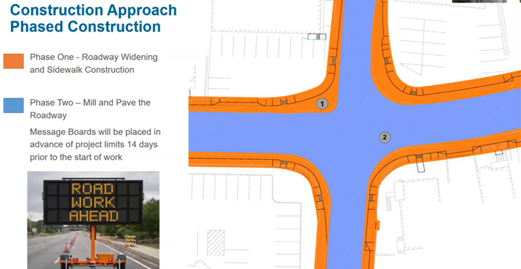
The work will take place in two phases: roadway widening and sidewalk construction, and milling and paving the road. Phase One will take place over three years, with daytime work happening between 7 am and 3:30 pm. Most of this work will be done off of Route 123, keeping both lanes of traffic open. Phase Two, scheduled for two months, will likely be done at night, narrowing the corridor to one lane with alternating traffic.
As next steps, Chappell is advancing the 75% design of the project for a spring 2027 MassDOT review, a 100% design submitted to MassDOT in the winter of 2027/2028, and a final design submission in the spring of 2028.
The project is tentatively scheduled for construction in 2029.
To learn more and to weigh in on the project’s conceptual design, email MassDOTProjectManagement@dot.state.ma.us and reference Project File No. 609520.
Streetsblog has migrated to a new comment system. New commenters can register directly in the comments section of any article. Returning commenters: your previous comments and display name have been preserved, but you'll need to reclaim your account by clicking "Forgot your password?" on the sign-in form, entering your email, and following the verification link to set a new password — this is required because passwords could not be carried over during the migration. For questions, contact tips@streetsblog.org.