In the Jamaica Plain neighborhood, the ongoing redesign project for the Arborway Parkway continues advancing closer to the final design phase with the goal of improving safety and accessibility for all corridor users including bicyclists and pedestrians.
Serving as one of the links connecting a string of parks along Boston's Emerald Necklace, the Arborway extends from Jamaica Pond down to the Arnold Arboretum before eventually turning into Morton Street at Franklin Park.
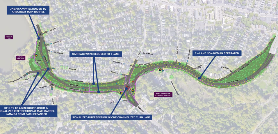
The Arborway Parkways Improvement Project, a project headed by the Department of Conservation and Recreation, DCR, focuses on the parkway section between Jamaica Pond and the Arnold Arboretum just past Forest Hills Road west of Forest Hills station.
According to a 2019 Road Safety Audit conducted by Howard Stein Hudson, a planning and engineering firm, there are several areas of concern along the project area including high crash rates, high travel speeds, and the need for improved pedestrian, bicycle and ADA accommodations.
“Crosswalks are missing throughout the corridor, which again becomes an issue of continuity for users through the project area. In addition, compliant ramps are not present at any crosswalks throughout the corridor,” read the report.
Since 2020, DCR has addressed some of these issues, completing small-scale improvements along the corridor which include replacing and repairing sidewalks and curb ramps along both sides of the parkway between Murray and Kelley Circles, and adding buffered bike lanes on sections of the parkway.
At a virtual public meeting held earlier this month, representatives from the project’s stakeholder group, a cohort of nineteen different community organizations, reviewed and provided feedback on the proposed preferred alternative presented by the project team.
Matthew Jasmin, a senior civil engineer with Howard Stein Hudson, presented a 3-D model detailing street interventions along the parkway which include reconfiguring Kelley Circle near Jamaica Pond to a mini roundabout and signalized intersection at the main barrel (the main road running in between the two side carriageways).
Further down near the northwest corner of the Arnold Arboretum, the project calls for converting Murray Circle, where the Arborway and Centre Street meet, to a signalized intersection.
According to the 2019 Road Safety Audit, 31 crashes were reported at Kelley Circle and Pond Street and an additional 44 crashes were reported at the Murray Circle and Centre Street at Arborway intersection between 2015 and 2017.
Jasmin says one of the core elements the team has tried to maintain with this design is, “respect for the Olmstead vision of both providing safe spaces for multiple modes of travel and also looking to respect some of the historic areas that have stayed in their current form since the original design back in the early 1900’s, late 1800’s."
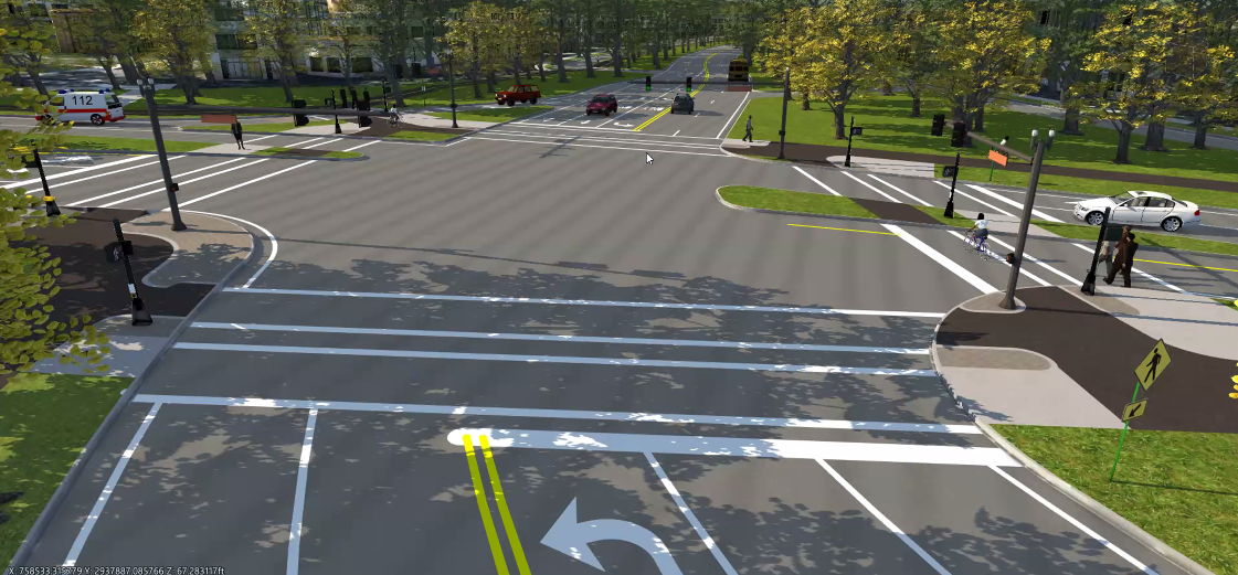 A 3-D rendering looking northbound showing the conversion of Murray Circle into a signalized intersection as part of the proposed preferred alternative shared during DCR’s public meeting earlier this month. Here, Centre Street runs left and right. The design aims to reduce crossing distances for pedestrians and bikes while still accommodating turns for cars in each direction.
“Some of the things we do appreciate about the revision from a retrofitted rotary (Murray Circle) to a signalized intersection is the ability to reclaim some of that center green space to some of the outside corners of the intersection,” said Jasmin.
By removing the existing circle, the proposed conversion of Murray Circle would reconfigure the green space, adding 1,300 square feet of parkland to the corners of the intersection:
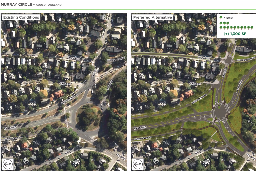 A side by side comparison of Murray Circle as it exists today (left) and what it could look like after the conversion to a signalized intersection as part of the preferred alternative design (right).
A similar reclamation of greenspace is proposed at Kelley Circle, where presently Jasmin says the trees and grassy areas within the circle are not only difficult to maintain, but are also unavailable for recreational use by residents and visitors.
“We’ve looked to eliminate that discontinuity in the park and add it back into a space that people can use and enjoy,” he said.
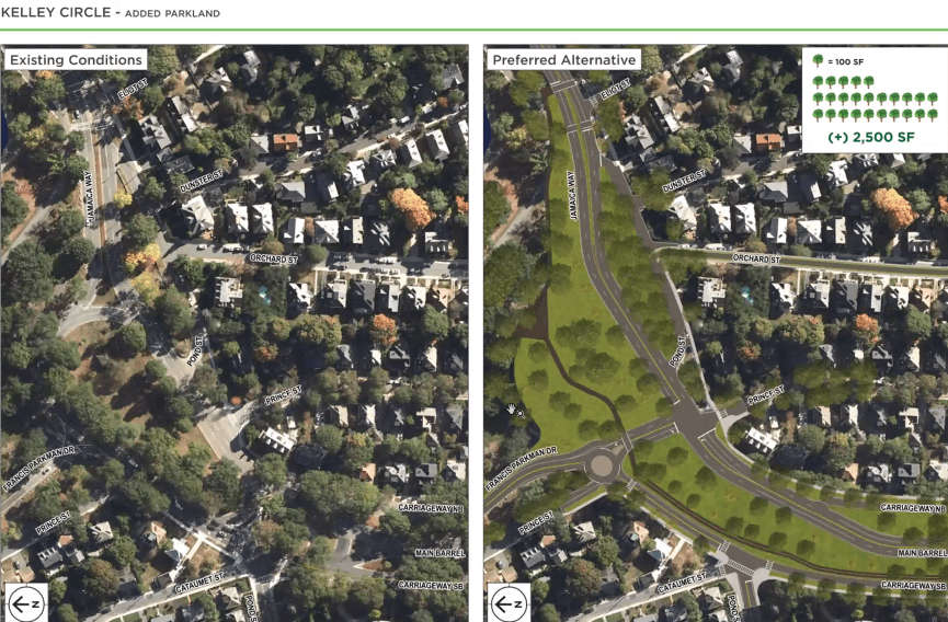 A side by side comparison of Kelley Circle as it exists today and the proposed preferred design presented by Howard Stein Hudson, the planning consultants for the Arborway Parkways Improvement project. Approximately 2,500 square feet of green space will be added through the combination of relocating and reducing the size of the existing roundabout and adding a signalized intersection.
Further south near the Arnold Arboretum, the consultants shared the proposed design for the crosswalk just south of the arboretum driveway near the Hunnewell Visitor Center where Jasmin says they’ll reclaim some of the paved area and widen the buffer significantly, facilitating the addition of a multi-use path.
Pedestrians will benefit from a shortened crosswalk where instead of crossing three lanes of active traffic, they’ll only have to cross two, one northbound and one southbound.
Over on the Upper Arborway, different elements such as a raised crossing, the narrowing of the roadway, and bump-outs for trees will also allow for traffic calming.
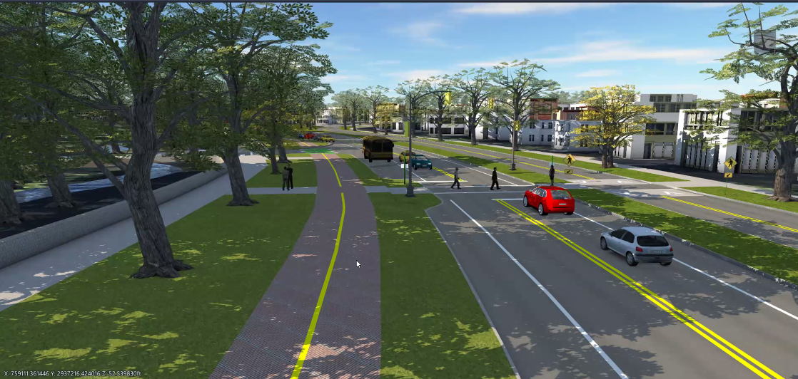 Looking northbound, this 3-D representation shows the proposed design for the crosswalk area just south of the arboretum driveway near the Hunnewell Visitor Center. The separated facility between the green spaces is expected to be between 12-14 feet wide and be used as either a shared use path or a separated bike lane. Currently, this is a three lane road with an unprotected painted bike lane in the southbound direction.
While the alternative presented during the meeting includes a multi-use path for bicyclists on the west side of the roadway, the design fails to include a bike facility along the east side, something stakeholder group member Peter Furth from the Boston Cyclists Union says is necessary.
In his feedback, Furth argued that since the east side carriageway will likely have very little traffic due to a lack of folks using it as a through traffic route, that this could potentially serve as the bike route on the east side.
“Bicyclists really need a route on the eastern side, the western side is great as a primary route, but a lot of people who will be coming from homes right along Arborway, but also from the Upper Arborway neighborhood, they want to go to JP center – they don’t want to have to cross the main barrel twice…there has to be a bike route on the east side as well as the west,” explained Furth.
During the presentation, Jasmin acknowledged this omission and shared the team is exploring options. “We’re looking for opportunities to still provide continuity if you're a cyclist traveling northbound to be able to access some of the robust facilities that currently exist even beyond our project limits adjacent to Jamaicaway, the two shared use paths that run along Jamaica Pond,” said Jasmin.
The next meeting is set to take place in January, 2023 where the team will share additional details about traffic conditions within the project area and participants will have a chance to meet two recently hired team members coming onboard to further assist with the project.
_______________________________________________________________________________________
Check the project page to review materials and register for upcoming meetings.