MassDOT Plans to Bridge A Major Barrier In Border-to-Boston Trail Network
MassDOT is designing a new trail connection that would fill a major gap in the Border-to-Boston trail network by linking the Independence Greenway and the Danvers Rail Trail in the City of Peabody.
At the end of January, MassDOT hosted a virtual public hearing for the project, which is now under design to go under construction in 2026.
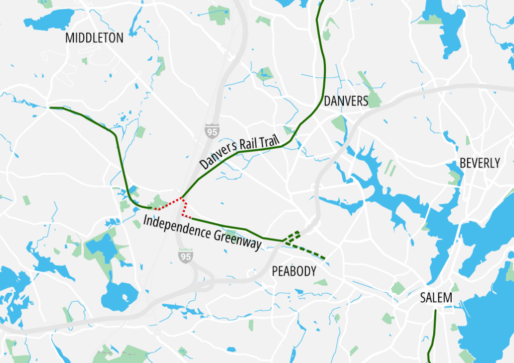
Currently, the Independence Greenway is made up of two disconnected segments that are divided by two large highways (see map above).
The western section runs about 3 miles from Lieutenant Ross Park, located about 1,200 feet west of the Route 1 expressway, to Russell Street, near Peabody’s northwest border.
The eastern section of Independence Greenway runs from Peabody Road, about 1,000 feet east of Interstate 95, to the Lahey Medical Center, near Route 128.
A project to extend that part of the trail further east, under an existing Route 128 underpass to a point near the Salem city line, is scheduled to begin construction this summer (StreetsblogMASS reporter Grecia White reported on the details of that project when it was under design in 2022).
In between those two disconnected segments of the Independence Greenway, a third major regional trail – the Danvers Rail Trail – has an inauspicious trailhead that’s wedged in between a gas station and the Interstate 95 embankment, across the street from a busy highway ramp to Route 1.
Project will thread over and under two major highways
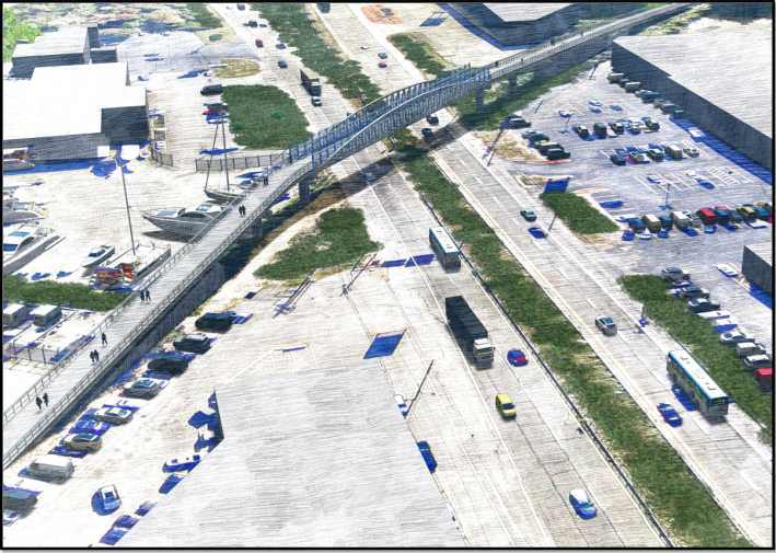
MassDOT is proposing to connect these trails with a project that will extend the western segment of the Independence Greenway over Route 1 with a new bridge (see rendering above), then continue under Interstate 95 with a new shared-use path along Lowell Street.
From there, the trail would continue through the woods just east of I-95 to connect to the existing eastern segment of the Greenway.
The project will also give Lowell Street a road diet by replacing one of its four existing motor vehicle lanes with a new 10-foot-wide shared-use path along the street’s southern curb under I-95.
A new crosswalk at the Route 1 off-ramp will provide a connection to the Danvers Rail Trail, on the north side of Lowell Street.
MassDOT aims to have the project fully designed by next January, then begin construction in early 2026.
Watch the January 30 project presentation here:
Streetsblog has migrated to a new comment system. New commenters can register directly in the comments section of any article. Returning commenters: your previous comments and display name have been preserved, but you'll need to reclaim your account by clicking "Forgot your password?" on the sign-in form, entering your email, and following the verification link to set a new password — this is required because passwords could not be carried over during the migration. For questions, contact tips@streetsblog.org.