Transit and Bike Riders Will Get More Space On Back Bay Streets This Year
Last week, Boston transportation planners hosted a virtual meeting to discuss their plans to add more bike lanes and bus lanes to various streets in Boston’s Back Bay neighborhood, which is currently a significant bottleneck for frequent-service MBTA bus routes and a major gap in the city’s growing network of protected bike lanes.
The City of Boston will reconfigure three Back Bay streets this year – Boylston, Berkeley, and Clarendon – to add new bus and bike lanes.
At the same time, city officials are finalizing proposed designs aimed at calming traffic and improving connectivity in the bike network on Beacon, Dartmouth, and Stuart Streets.
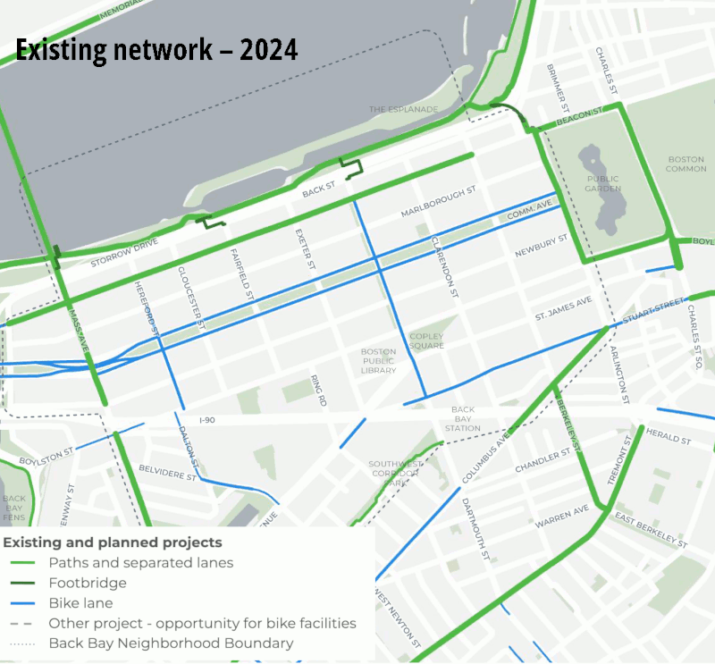
Collectively, these projects will fill in major gaps in Boston’s bike network by connecting protected bikeways that already exist in downtown Boston to popular bike routes like Tremont Street in the South End, the Massachusetts Avenue bridge, and the Charles River Esplanade:
Boylston Street
The first project the city will tackle during this construction season is a redesign of Boylston Street that will add a wide separated bike lane along the northern curb of Boylston from Mass. Ave. to Arlington Street.
The existing Boylston Street generally features three lanes for moving vehicles, with on-street parking along both curbs. However, double-parked vehicles frequently block one or more of those lanes, and at times, there is only one lane available for moving traffic.
Under the city’s proposed design, Boylston Street would have two lanes for general traffic, a dedicated eastbound bike lane along the northern curb, and on-street parking in between.
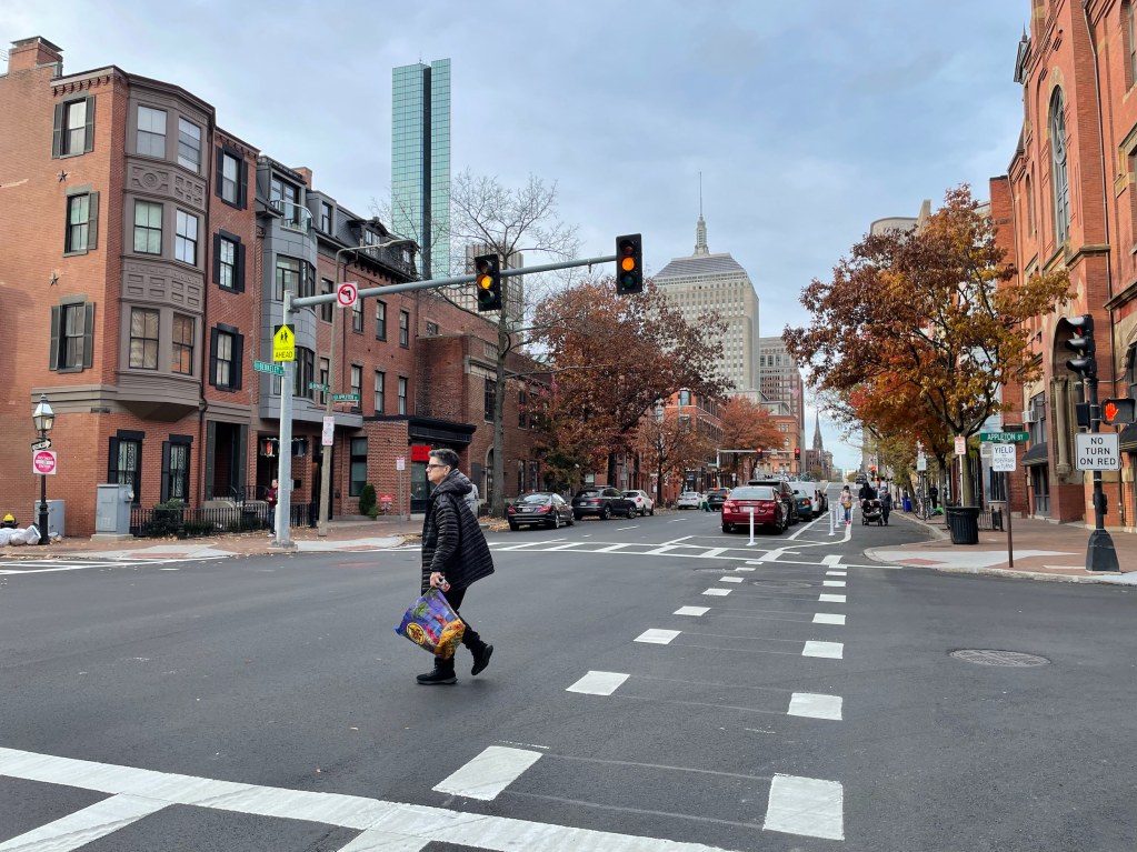
The project will also make permanent a dedicated bus lane along the southern curb of the street – something that the city initially tested during the Orange Line shutdown of 2022 (see photo below, pictured next to the Boston Public Library looking east toward downtown Boston).
This segment of Boylston gets heavy bus traffic from two frequent-service MBTA bus routes: the 9 and the 39.
Near Copley Square, where double-parked food delivery drivers frequently block two or more lanes, the city is adding more curbside parking regulations, and will also install a dedicated parking area for scooters in front of the Chick-Fil-A.
The city aims to start work on these changes within the next few weeks.
Berkeley Street
The next project on the city’s agenda for this construction season will be a repaving project on Berkeley Street, which would be followed by the installation of a new curbside parking-protected bike lane along the eastern curb from Columbus Ave. to the Commonwealth Avenue mall.
Much like Boylston Street, the current Berkeley Street features three lanes for motor vehicles and two lanes of curbside parking. The city’s new design will replace one moving motor vehicle lane with a new curbside bike lane, separated from traffic by a row of on-street parking.
This project would extend a protected bike lane that the city installed last fall between Tremont Street and Columbus.
The city had initially planned to extend this bike lane all the way to Beacon Street, to provide a connection to the Esplanade via the Fielder Footbridge.
However, Boston Transportation Planner Nathaniel Fink said that the city decided to change that plan in response to neighborhood feedback that was “centered around concern for safety at the intersection of Berkeley and Beacon in particular.”
“This is an intersection where two heavy streams of traffic are coming in, both from Berkeley Street and from Beacon Street, and trying to turn onto Storrow Drive,” observed Fink. “And because of those heavy traffic flows, we sometimes get long queues and we sometimes get frustrated drivers who are behaving in ways that we do not want them to behave.”
Instead of directing more bike traffic into the Storrow Drive bottleneck, the city is instead planning two additional bikeway projects, on Dartmouth Street and Beacon and Arlington Street, as alternative routes. More on those projects below.
The Berkeley Street project would be implemented this summer, after the Boylston work is complete.”
Clarendon Street
The last Back Bay street project slated for implementation this summer is a relatively short bus lane for Clarendon Street, to mitigate a chronic bottleneck for thousands of bus riders at the end of the MBTA’s 39 bus route.
This was another bus lane that had initially been tested during the MBTA’s 2022 Orange Line shutdown, and will now become permanent.
The bus lane would extend from the Boylston Street bus lane south to the Back Bay station busway, which is one of the busiest stops on the 39’s route.
Beacon Street repaving
Finally, the city also plans to re-pave numerous other Back Bay streets this year.
One of the streets that’s slated to get a fresh coat of asphalt is Beacon Street, which is home to one of the neighborhood’s oldest parking-protected bike lanes.
The existing Beacon Street bike lane is riddled with potholes and bumps, so the city’s paving project should make it a considerably smoother ride.
In design: filling the Beacon Street gap
Boston officials are also still refining their designs for the block-long bikeway gap on Beacon Street between Arlington and Berkeley Street.
Under the city’s current plans, which could be implemented before the end of 2024, the city would install a curbside parking-protected bike lane on the south side of Beacon Street from Arlington to Berkeley. Then, bikes continuing west would use the traffic signal to cross to the existing protected bike lane on the north side of Beacon Street, away from the Storrow Drive on-ramp traffic.
The revised design would also reduce the number of lanes on this block of Beacon Street from three to two – a move that officials hope will serve to curb aggressive driving.
“There is a center lane that is supposed to be a through lane, but folks use it to cut off and get ahead of the right-turning traffic that is waiting in the right-turn lane,” explained Fink. “With a (two-lane configuration), we think that this is going to make it harder for drivers to turn when they’re not supposed to.”
In a future project to reconfigure five intersections around the periphery of the Public Garden, the intersection of Arlington and Beacon will also be reconfigured to add a new crosswalk across Beacon, and the existing Arlington Street bike lane would be repainted as a two-way bikeway to accommodate northbound bike traffic to the Fielder Footbridge.
In design: Dartmouth Street bikeway
In lieu of the proposed connection to the Esplanade on Berkeley Street, the city is now proposing an additional two-way protected bikeway on Dartmouth Street, between the new Boylston Street bike lane at Copley Square and the Dartmouth Street footbridge to the Esplanade over Storrow Drive.
This section of the street already has an unprotected paint-only bike lane, but the city’s proposal would replace a lane of metered on-street parking to create a two-way bikeway along the eastern curb of the street. The project would not affect the two existing motor vehicle lanes on this segment of Dartmouth.
According to the city’s presentation, this bikeway would be implemented with quick-build materials near the end of 2024 or in 2025.
In design: Crosswalk improvements at Stuart and Dartmouth
Finally, the city is also working on a modest “quick-build” project to improve safety at the intersection of Stuart and Dartmouth Streets next to Back Bay Station.
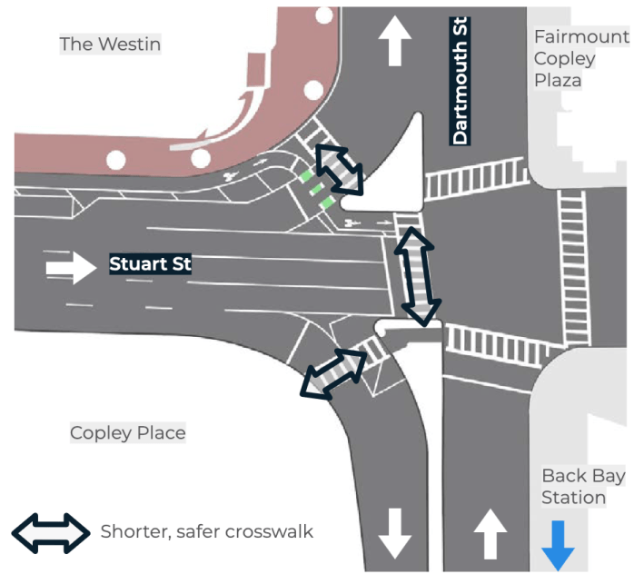
This intersection mixes heavy foot traffic heading to and from the Back Bay Stion with fast-moving vehicles from the Massachusetts Turnpike, and is a hot spot for crashes according to Boston’s Vision Zero crash database.
“There are uncomfortable pedestrian crossings and there are high turning speeds for vehicles,” said Fink. “Those are made possible by very wide turning lanes that are there today and built in the 1950s and 1960s to accommodate fast-moving traffic, not as reflective of the dense urban environment that we have today.”
The city is planning to re-stripe the turning lanes from Stuart Street so that cars have a narrower lane, and pedestrians will be less exposed in the crosswalks between the intersection’s islands.
Vew a copy of the slide deck from the city’s May 2 meeting presentation here, or find additional information at boston.gov/back-bay-streets.

Read More:
Streetsblog has migrated to a new comment system. New commenters can register directly in the comments section of any article. Returning commenters: your previous comments and display name have been preserved, but you'll need to reclaim your account by clicking "Forgot your password?" on the sign-in form, entering your email, and following the verification link to set a new password — this is required because passwords could not be carried over during the migration. For questions, contact tips@streetsblog.org.