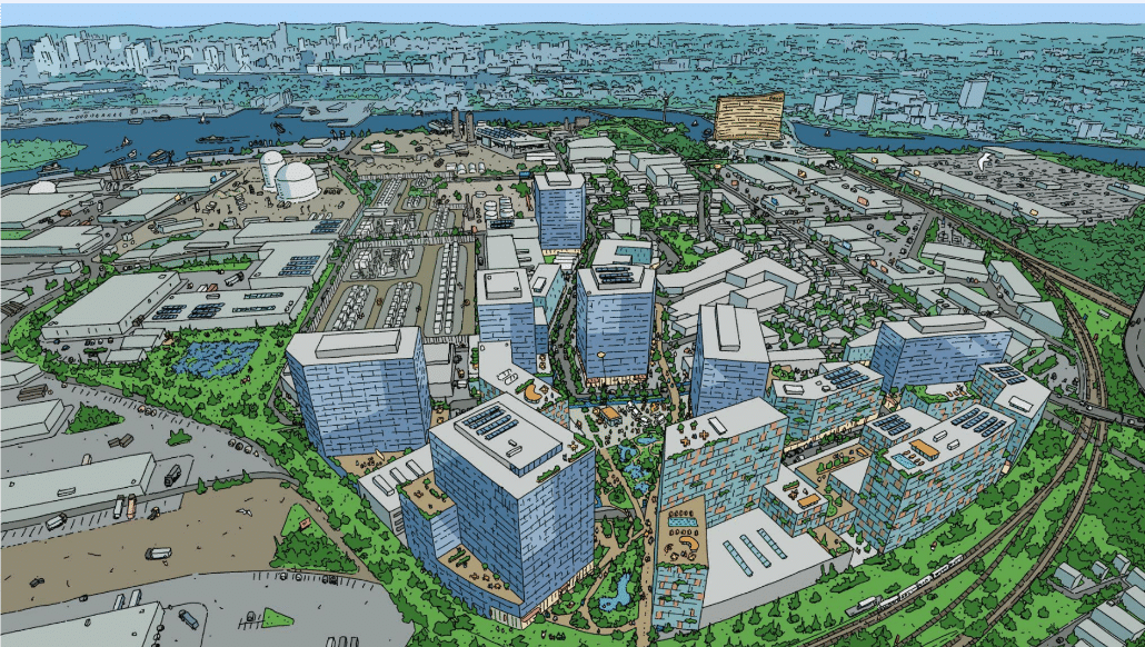
Developers have filed plans to replace a former ExxonMobil oil tank complex in Everett with a new neighborhood of high-rise buildings, including over 3,000 new homes, next to the MBTA's Newburyport-Rockport regional rail line and a proposed new bus rapid transit route.
According to an August filing with the Massachusetts Environmental Policy Act office, The Davis Companies, a Boston-based real estate investment firm, would like to build about 7.2 million square feet of new offices, manufacturing spaces, and apartments on 66 acres it owns just southeast of Sweetser Circle in Everett.
The firm is also proposing, as a "phase one" project, a large battery storage facility with new electric power substations on an adjacent 20 acre site that it owns on either side of Beacham Street, next to other industrial properties in the area.
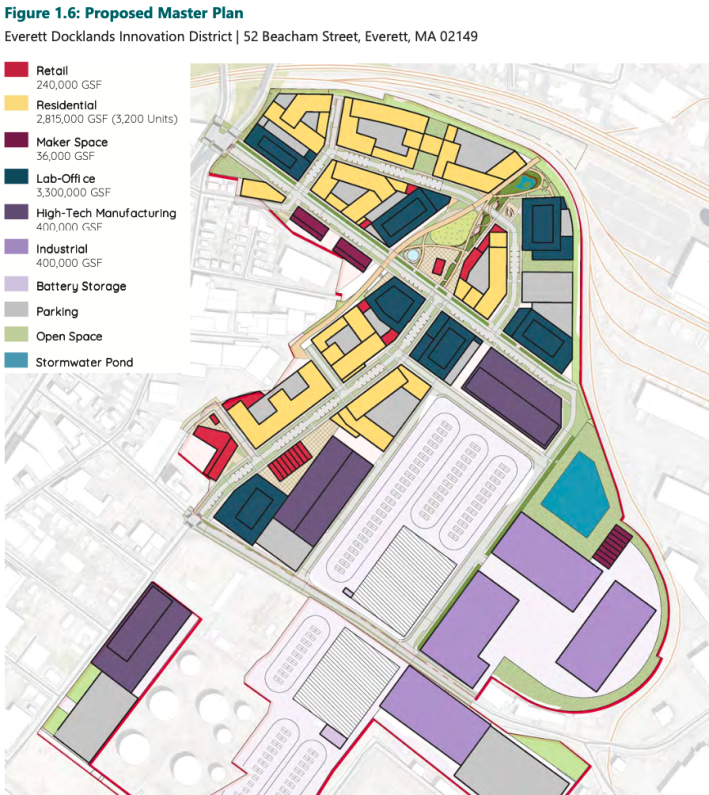
If built, the neighborhood would increase the number of homes in the City of Everett by roughly 15 percent.
But the project faces major obstacles. For starters, the site is contaminated with pollution from its decades of use as a fossil fuel storage site (earlier this year, Attorney General Andrea Campbell entered into an agreement not to sue the landowners in exchange for their commitment to clean up the property).
Once the site is cleaned up, it will also require a major expansion of infrastructure – above and below the ground – before new buildings go up and new residents move in.
One of the biggest unresolved questions is what kind of transportation infrastructure the new neighborhood will get – and by extension, whether its new residents and workers will be T riders, or car owners who pile more traffic into Everett's already-congested streets.
Lots of plans for transit improvements – but not much funding
Jay Monty, the City of Everett's Director of Transportation and Mobility, told StreetsblogMASS that transit improvements for the entire lower Broadway district are the subject of some “very active conversation right now."
"Timing-wise, when you layer the ExxonMobil site and potentially a new soccer stadium and the Encore Broadway project (a proposed expansion of the Encore casino complex), it's good that we’re having these conversations now," said Monty.
In June, the MBTA and the City of Everett won a $22 million federal grant to build a physically-separated busway along Broadway between Sweetser Circle and Sullivan Square in Boston – a facility that will support faster, more frequent bus service on the redesigned MBTA route 109 and could potentially be part of a proposed extension of the Silver Line.
The city also won a $1.2 million federal grant this year to study ways to improve mobility across the Revere Beach "Parkway," the six-lane highway that cuts off access between the established neighborhoods to the north and the rapidly-growing former industrial lands to the south.
One idea the city wants to consider is adding a new commuter rail station on the Newburyport/Rockport line, which currently makes no stops in Everett but curves around the northern edge of the ExxonMobil site.
All of these proposed transit improvements could make this part of Everett as well-connected to the regional transit network as Boston Landing in Allston, a transit-oriented development that was designed around a new regional rail station that opened in 2017.
But Monty says that financing and building the public transit infrastructure that the city needs to support a new urban neighborhood is "a chicken-and-egg problem."
"The big sticking point to get there is how to get people to the site," Monty told StreetsblogMASS. "There's roadway infrastructure that can’t handle the additional traffic, or transit infrastructure that doesn't exist yet and isn’t funded. Until we get over that issue, it’s not a guarantee that we’re going to get high-rise mixed-use."
"We’re trying to have the conversation with MassDOT and the T that these investments need to happen now. The Governor wants to build housing and this site is the largest development site in the region. It’s a great opportunity to do something great and fulfill the Governor’s goals but it will require investment beyond what a private developer can do on their own – they’re already putting in $80 million to clean up a contaminated site."
Filing suggests project could add 5,588 parking spaces
The project's environmental impact filing offers a hint of those transportation challenges.
The document suggests that the full development could add 5,588 parking spaces to Everett, and that all the new homes, offices, and manufacturing spaces they're proposing to build could attract up to 62,474 new vehicle trips per day to the surrounding roadways.
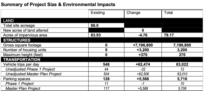
Massachusetts Environmental Policy Act guidelines require developers to use Institute of Transportation Engineers (ITE) trip generation formulas for these calculations, even though those formulas are notorious for over-estimating parking requirements and traffic impacts, especially in urban mixed-use developments.
The ITE formulas produce “unadjusted” vehicle trip estimates, which do not account for trips made on public transit, biking, or walking.
As a practical matter, it is not possible for this location to generate 62,000 car trips a day. Broadway, which is essentially the only street that would connect the project to the rest of the region, already experiences heavy congestion, and will have even less space available for private vehicles after the proposed new MBTA busway gets built.
"Hopefully those numbers aren’t nearly as high in the end,," says Monty. "But it’s dependent on the conversations we have with the T and MassDOT, and whether we can get these transit investments in a timely manner."
