Skip to content

Here’s the MBTA’s Plan to Make the Green Line B Branch Accessible

Earlier this week, the MBTA hosted an informational meeting with potential design-build contractors to outline its plans to upgrade 10 stops on the B branch of the Green Line with wider platforms and accessibility for wheelchair users.
Two images side-by-side show a green line train at a platform. The left image is a photo of a train next to a broken, narrow asphalt platform in the median of a multi-lane roadway as a pedestrian crosses in a crosswalk towards it. The right image is a rendering of a wider platform with benches, lights, and wayfinding signage and a fence that protects the platform from the adjacent roadway.
A comparison of an existing stop on Commonwealth Avenue along the Green Line's B Branch (left) and an MBTA rendering showing what stops will look like in the future, after a project to make 10 stops compliant with the Americans With Disabilities Act. Left image courtesy of Wikimedia Commons user Pi.1415926535, licensed under Creative Commons BY-SA 3.0; right image courtesy of the MBTA.

Earlier this week, the MBTA hosted an informational meeting with potential design-build contractors to outline its plans to upgrade 10 stops on the B branch of the Green Line with wider platforms and accessibility for wheelchair users.

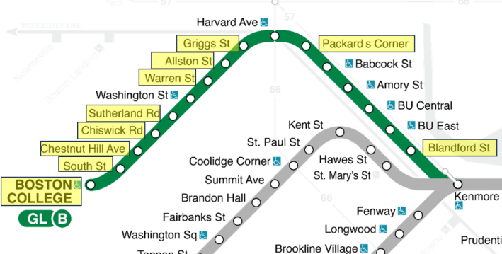
According to the MBTA’s presentation, the project, tentatively scheduled to go under construction next year to be completed by the end of 2026, would upgrade 10 stops on the B branch west of Kenmore Square, where the Green Line runs in the median of Commonwealth Avenue.

A section of the MBTA rapid transit map focused on the B branch of the Green Line, highlighting its non-accessible stations at (from right to left) Blandford Street, Packard's Corner, Griggs Street, Allston Street, Warren Street, Sutherland Road, Chiswick Road, Chestnut Hill Ave., South Street, and Boston College.

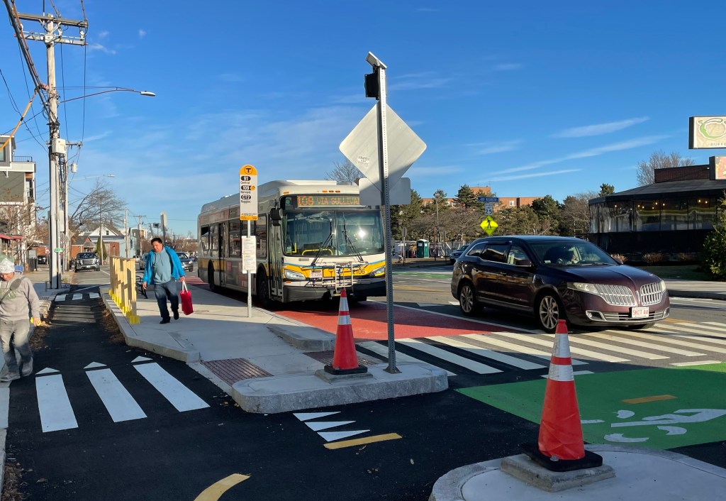
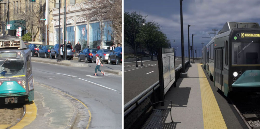
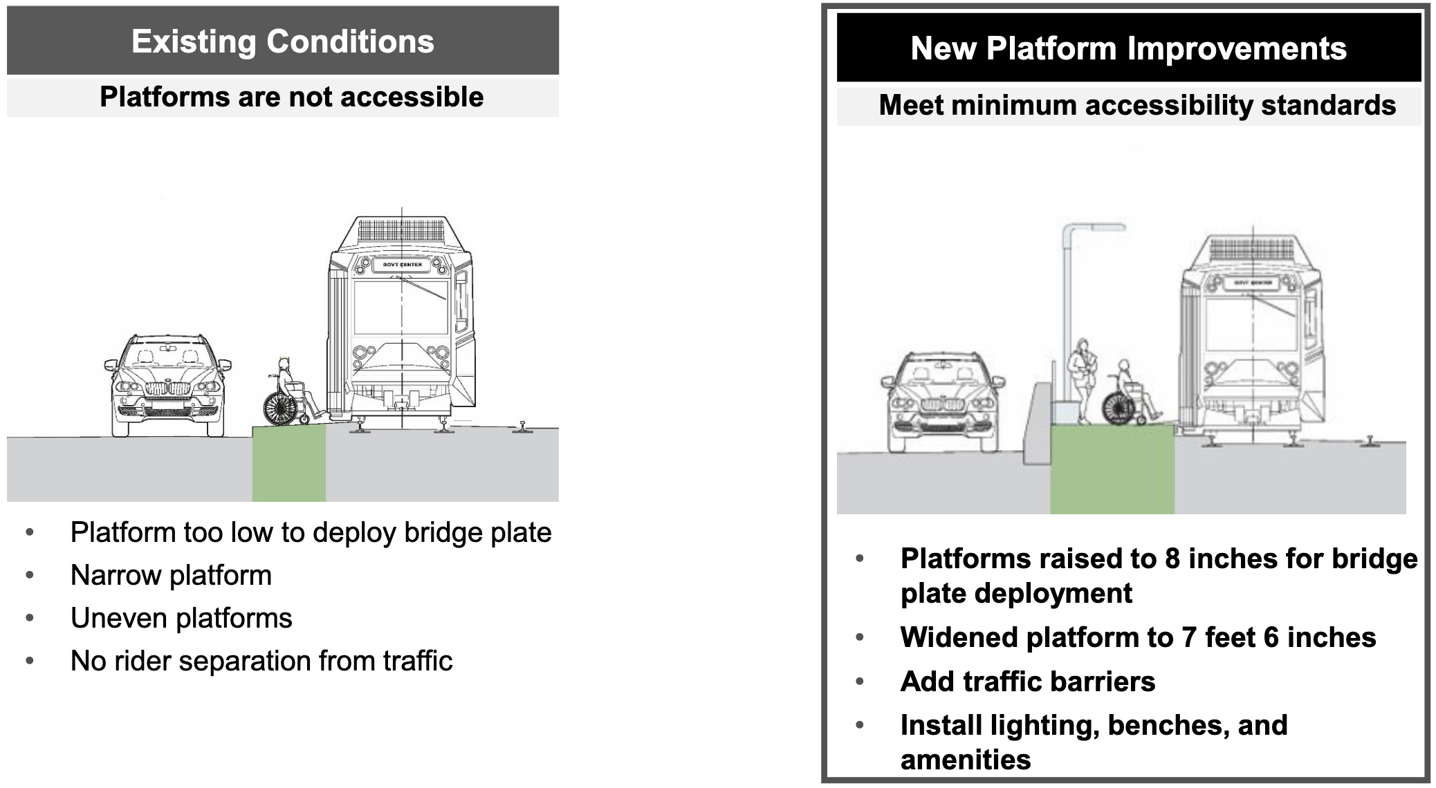
Many of these stops today lack the basic amenities riders would expect to find at most bus stops, with nothing more than a narrow asphalt strip, with no shade or shelters, and no buffer between the platform and the adjacent roadway traffic on Commonwealth Avenue (see the photo at the top of this article for an example).

To make these stops compliant with the Americans With Disabilities Act (ADA) and other building codes, the project will widen those platforms and elevate them by 8 inches to make them level with the floors on Green Line trains.

The project will also add robust crash barriers between the platforms and the roadway, and add basic station amenities like lighting, benches, and wayfinding signage.

Two side-by-side cross sections of a light rail stop. The left side, labelled "existing conditions" shows a wheelchair on a narrow strip between a train and a car. Bullets under the illustration read "platform too low to deploy bridge plate," "narrow platform," "uneven platforms," and "no rider separation from traffic."

The right side, labelled "New platform improvements – meet minimum accessibility standards" shows a wider, elevated platform where a wheelchair is able to board the train at level, next to a streetlight and a barrier that divides the platform from an adjacent car on the roadway. Bullets under the illustration read "Platforms raised to 8 inches for bridge plate deployment," "widented platform to 7 feet 6 inches," "add traffic barriers," and "install lighting, benches, and amenities"

Additionally, although it’s technically accessible already, the T plans to relocate the last stop on the B branch – the Boston College stop – from its current location, at the entrance to the Lake Street layover yard, to the median of Commonwealth Avenue just east of the Lake Street intersection.

All these changes will also make the B branch compatible with the T’s new, longer “Type 10” Green Line trains, which are scheduled to enter service in 2027.

Earlier this year, the T received a $67.6 million Federal Transit Administration grant to upgrade 14 non-accessible stops along the Green Line’s B and C branches. This project will address 5 of the stops included in that grant application.

Photo of Christian MilNeil
Christian has edited StreetsblogMASS since its founding in spring 2019. Before that, he was a data reporter for the Portland Press Herald in Maine. Got tips? Send them to me via Signal, the encrypted messaging app, at 207-310-0728.

Read More:

Streetsblog has migrated to a new comment system. New commenters can register directly in the comments section of any article. Returning commenters: your previous comments and display name have been preserved, but you'll need to reclaim your account by clicking "Forgot your password?" on the sign-in form, entering your email, and following the verification link to set a new password — this is required because passwords could not be carried over during the migration. For questions, contact tips@streetsblog.org.

More from Streetsblog Massachusetts

MBTA Seeks Vendor Input For Possible Platform Screen Door Pilot Program

May 21, 2026

Thursday’s Headlines Are Not Impressed

May 21, 2026

T Threatens Recalcitrant City Hall With Eminent Domain to Ban Cars From Summer Street On World Cup Match Days

May 20, 2026

MBTA Launching New Year-Round Boston Harbor Ferry Loop In June

May 19, 2026

MBTA Wants You to Help Plan for Its Future with ‘Focus 2050’

May 19, 2026
See all posts