The Path Forward for Allston’s Highway Megaproject Is Getting Narrower
Since 2014, state transportation officials and their engineering consultants have been struggling to figure out how they can tear down and rebuild twelve lanes of highway through a narrow strip of land that’s hemmed in by the region’s primary east-west rail line and the banks of the Charles River in Allston.
Over the years, consultants and bureaucrats have come up with lots of theoretical arrangements to stack or squeeze all those lanes through Allston without any major road closures over the course of a decade-long construction project.
But time and time again, environmental rules (remember the short-lived plan to build a highway through the middle of the Charles River?), logistical conflicts (remember the plan to cut off access to a critical MBTA bridge?), and financial constraints have sent those consultants back to their drawing boards.
For several years now, some of the project’s key stakeholders have been asking whether spending billions of dollars to rebuild 60-year-old highway infrastructure makes any sense for a city that’s struggling to meet its legally-mandated goals to reduce traffic pollution.
But the project’s intractable technical and financial challenges suggest another, more fundamental question: whether MassDOT’s deep-seated desire to rebuild 12 lanes of highway through Allston was ever remotely realistic.
Choking on the ‘throat’
The Allston Mulimodal Project has always struggled with two major constraints.
One is financial – the state has never been able to come up with a credible financial plan for the project.
But the other is physical: all of the project’s proposed highways and rail lanes need to fit through a tight strip of land between the Boston University campus and the Charles River – an area that project planners have taken to calling “the throat.”
When this segment of the Turnpike got built in the 1960s, highway builders were able to solve this tricky problem of geometry by lofting the Turnpike over the railroad tracks on an elevated concrete viaduct, pictured below:
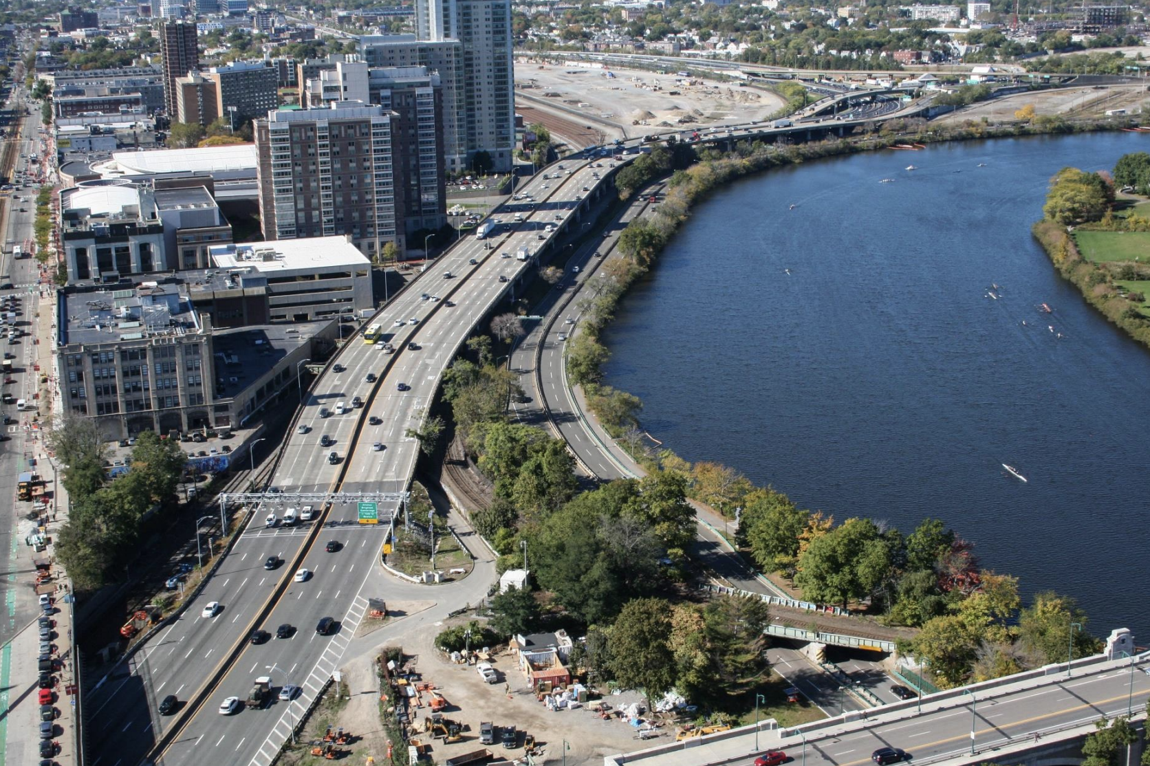
But after 60 years, that concrete is now crumbling away, and the viaduct needs to come down.
MassDOT has considered trying to build a new viaduct to carry either the Turnpike or Soldiers Field Road on top of the railroad tracks has been considered at various stages in the past decade.
But the viaduct is extremely unpopular with Allston’s residents and their elected officials, who see it as a huge barrier that blocks their access to the Charles riverfront.
The viaduct solution also has massive technical challenges. First, viaducts are expensive. In the 1960s, lavish highway subsidies from Washington made it easy for state highway agencies to finance extravagances on the new interstate highway system, but things have changed. The Allston project, with its multi-billion-dollar price tag, needs to cut costs wherever possible.
The other fundamental problem with any viaduct plan is that there’s no space here to build a new elevated highway while the old one gets torn down.
In the 1960s, it was possible to build a new interstate highway through Allston without disrupting traffic, because the highway didn’t exist yet. Today, staging a major construction project on top of or next to a major highway will be considerably more complicated.
Designing for a 6-lane Turnpike
Although parts of Interstate 90 through Allston are currently 8 lanes wide, MassDOT has told stakeholders to expect that the highway will be reduced to 6 lanes for the duration of the project’s decade-long construction period.
Several members of the Allston project’s stakeholder task force are beginning to wonder if the Turnpike should be designed to be 6 lanes for good – an idea that could considerably simplify the project’s construction logistics.
“Can we survive with a 6-lane Turnpike? Sure we can, because we’re doing it right now,” observes Emily Norton, a Newton resident and executive director of the Charles River Watershed Association.
Norton points out that nearby segments of the Turnpike have already been narrowed to a 6-lane configuration for several years for the construction of air-rights developments in the Fenway neighborhood.
“If MassDOT wants to build 8 lanes here, then what we’re actually talking about is a highway expansion project. Because it’s been 6 lanes for over 5 years now. It would be 6 lanes through the decade-plus of construction (of the Allston Multimodal Project),” says Norton. “Can you tell me anywhere else in the state where you’re planning a highway expansion next to a new commuter rail stop?”
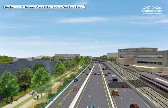
By similar reasoning, Norton thinks that the adjacent Soldiers Field Road should also be considered for a road diet. The agency in charge of that highway, the state’s Department of Conservation and Recreation (DCR), has already endorsed plans to turn that roadway into a calmer 2-lane street on the other side of Allston, in Herter Park.
By designing for fewer lanes in the future, Norton thinks that MassDOT could save hundreds of millions of dollars in construction costs, mostly by making the project’s construction logistics considerably simpler.
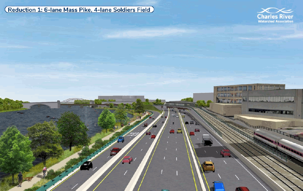
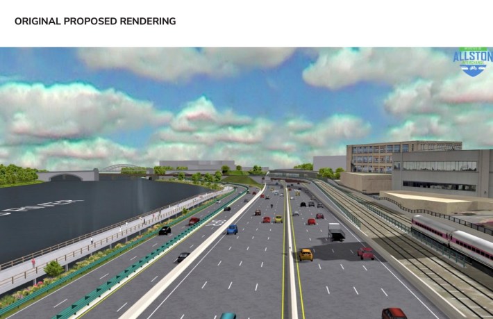
But Norton’s primary interest is in swapping pavement for more greenery along the banks of the Charles River.
Last year, Norton’s organization produced renderings (pictured above and at the top of this article) to illustrate how much extra greenery the state could gain if it swapped two or four highway lanes for a more natural riverbank along the river.
Designing a bigger bottleneck
In a project task force meeting last June, MassDOT offered advocates a brief analysis of the 6-lane option.
Mike Hall, a project consultant from TetraTech, presented data from MassDOT’s automated toll collection gantry 13, which is located in the “throat” segment of the Turnpike.
“The capacity of the highway is about 1,760 vehicles per hour per lane, or a capacity of about 7,000 cars per hour on the highway” in each direction, said Hall.
“Anything above that, what happens is the density of the vehicles become so great that the traffic flow starts to break down, and speeds actually drop, and volumes drop,” said Hall. “If the highway were reduced from 4 lanes to 3 lanes in each direction, the new capacity would be about 5,300 vehicles per hour” in each direction.
Hall then asserted that traffic would overwhelm a 6-lane Turnpike.
“The future volumes that we use for analysis range from anywhere from 6,400 to 7,300 vehicles per hour. So the amount of volume that’s trying to get through that piece of the highway exceeds the capacity of three lanes,” said Hall.
What Hall didn’t mention, though, is that the numbers he was using were roughly 20 percent higher than actual observed traffic volumes from the present day.
StreetsblogMASS downloaded the actual eastbound traffic data from that gantry for the first quarter of 2025, which you can look at in this spreadsheet.
It shows that hourly traffic volumes on Interstate 90 rarely exceed 6000 cars per hour in either direction.
For the entirety of March 2025, eastbound traffic volumes were under the theoretical 5300-cars-per-hour capacity of a 3-lane Turnpike 96 percent of the time.
Westbound traffic volumes were under that threshold 98 percent of the time.
When volumes do exceed those thresholds, it’s during rush hours, when the Turnpike turns into a waiting room for drivers trying to exit onto congested city streets (particularly Back Bay for eastbound traffic, and Newton Corner for westbound traffic).
During June’s task force meeting, one stakeholder from the Allston neighborhood, Jessica Robertson, pointed out that a wider Turnpike wouldn’t do anything to address those bottlenecks – and in fact, might only make them worse.
“There are limited number of access points, with a limited number of lanes,” noted Robertson.
Hall and MassDOT did not respond to inquiries from StreetsblogMASS about why they’re assuming a 20 percent increase in Turnpike traffic by 2040.
Those assumptions appear to ignore Amtrak and the MBTA, which both intend to considerably increase intercity rail service in the I-90 corridor. A single MBTA Worcester Line train has seating capacity for over 700 passengers, and the T is planning to start running those trains every 30 minutes by 2026.
Assumptions that traffic in Allston will increase also contradict the legal mandates of the Massachusetts Global Warming Solutions Act and the Commonwealth’s climate plans, which will require an overall reduction in private motor vehicle traffic over the next two decades.
MassDOT invoices show that Hall’s firm, TetraTech, had collected $4.4 million in consulting fees from MassDOT as of September 2024.
In addition to its traffic modeling work, TetraTech is also getting paid for environmental permitting work related to the highway project’s impacts on the Charles River shoreline. Those impacts, and their associated permitting costs, will be considerably more expensive if MassDOT continues insisting on an 8-lane Turnpike design.
Local streets are already getting slimmer
But in other parts of the project, MassDOT is showing signs that it’s open to imagining a lower-traffic future.
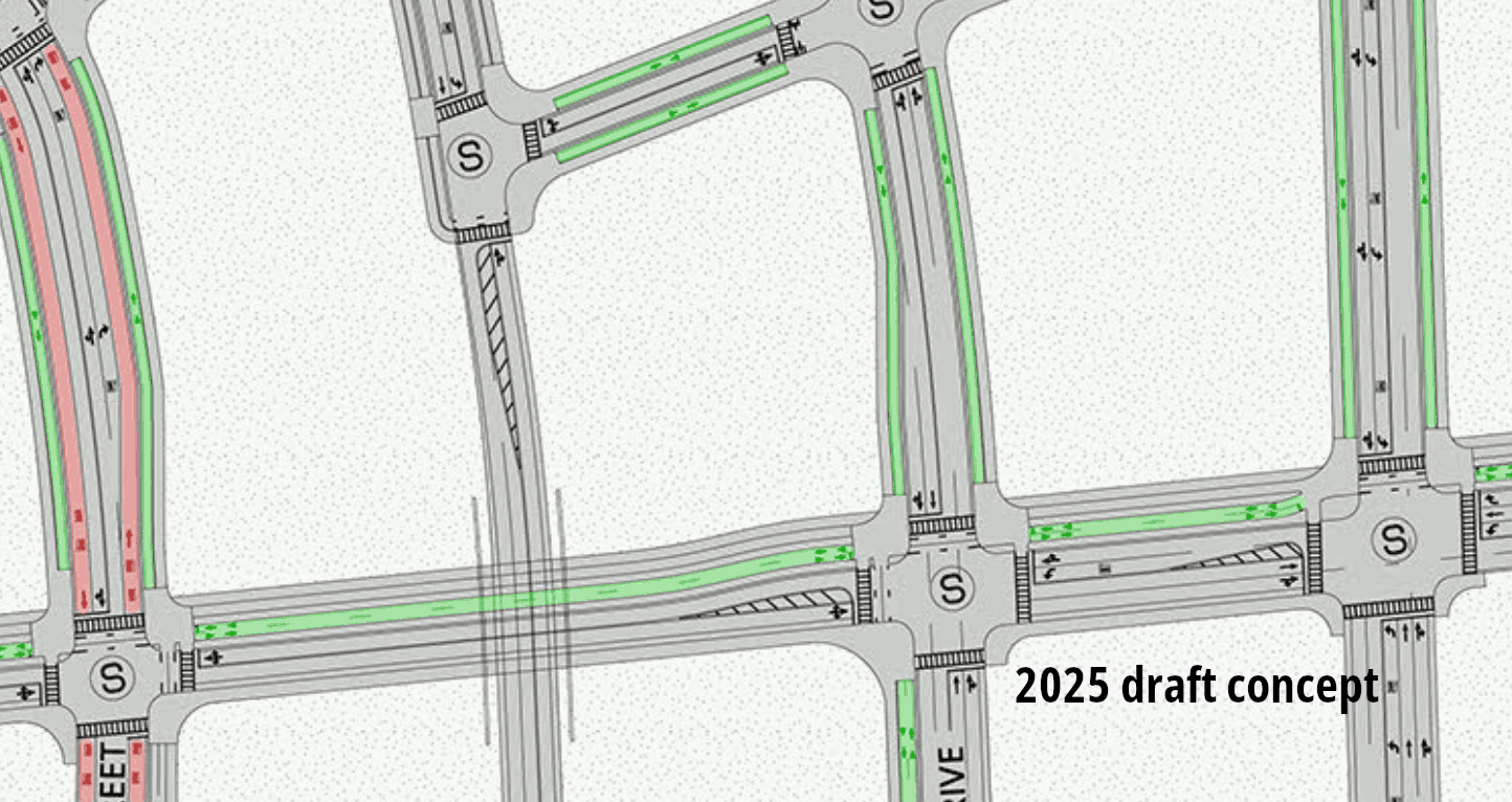
During the March 2025 task force meeting, which focused on the agency’s plans for the West Station transit hub, the agency also shared a glimpse of its updated conceptual plans for new local streets around West Station.
Under the agency’s previous plans, many of those streets would have been massive 4- and 5-lane roads.
But more recent designs show that many of those streets have gotten considerably slimmer.
The animated GIF below compares plans from the project’s 2022 environmental impact report with the concept that MassDOT presented in March:
The Allston Multimodal Project will hold another task force meeting this evening, April 16, at the Josephine A. Fiorentino Community Center at the corner of Western Avenue and Antwerp Street in Allston.

Read More:
Streetsblog has migrated to a new comment system. New commenters can register directly in the comments section of any article. Returning commenters: your previous comments and display name have been preserved, but you'll need to reclaim your account by clicking "Forgot your password?" on the sign-in form, entering your email, and following the verification link to set a new password — this is required because passwords could not be carried over during the migration. For questions, contact tips@streetsblog.org.