Closing the Gap on New Bedford’s Waterfront: New Path Would Link Route 6 Bridge to Downtown Sidewalks

A critical area highway junction in downtown New Bedford that currently lacks accessible bike and pedestrian connection finally has a project in the works to fix it.
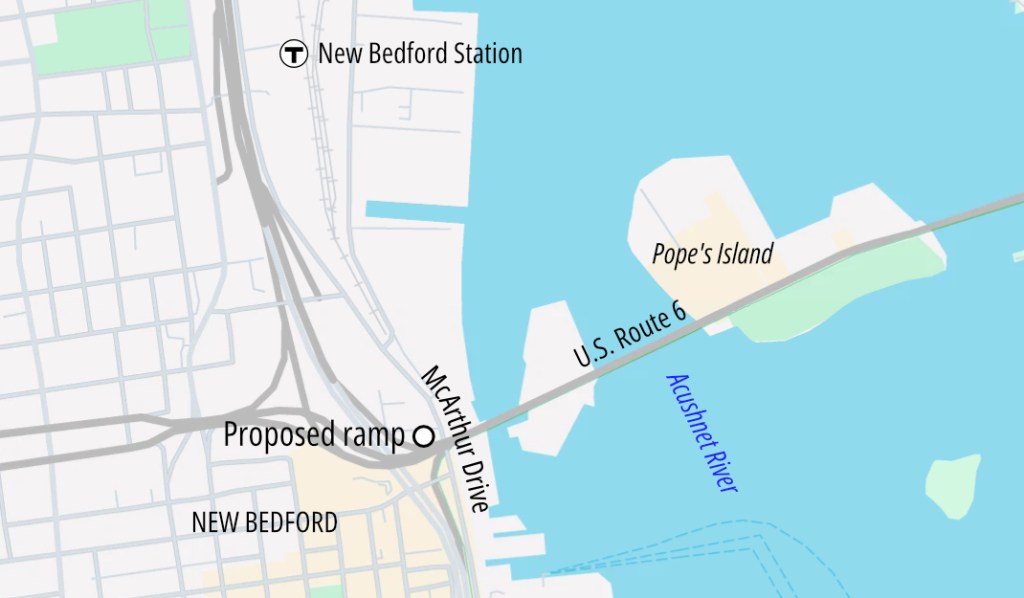
On September 10th, MassDOT held a public virtual hearing regarding a new bicycle and pedestrian ramp that they’re proposing on the northern side of Route 6 (the New Bedford-Fairhaven bridge over the Acushnet River) to the harborfront MacArthur Drive in New Bedford – a project that will also improve regional bike and pedestrian connections to the New Bedford South Coast Rail station.
Megha Parameswaraiah and Darryl Gallant spoke on behalf of the engineering team at Michael Baker, while Adetoyin Olaoye and Hung Pham from MassDOT drove the meeting and facilitated the public comment portion. Slides can be found here.
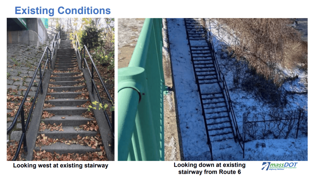
Currently, the site is not ADA accessible. The sidewalk on the northern side of the New Bedford-Fairhaven bridge ends at a staircase with 20-foot elevation change down to MacArthur Drive.
There’s an accessible pedestrian path connecting the local street network in New Bedford on the south side (eastbound) of Route 6, but there is no equivalent on the north side, where the MBTA station is.
MassDOT and engineering partner, Michael Baker, presented their $7.1 million-dollar design-stage plans for fixing these problems.
With combined funding from the Federal Highway Administration (80 percent) and MassDOT (20 percent) and as part of the statewide Transportation Improvement Program, their proposal would create a new, bidirectional, shared use ramp that connects Route 6 and MacArthur Drive.
The project would also add a new crosswalk across MacArthur Drive near the new path, remove the old concrete stairway, and upgrade connecting sidewalks and curb ramps while extending the west-side sidewalk 200 feet further north up MacArthur Drive.
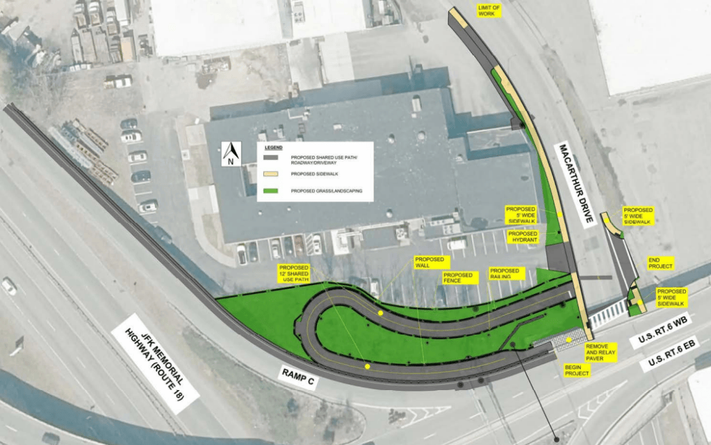
The shared use path will be 12 feet wide to allow for all users to navigate it comfortably, and the improvements will all be ADA-compliant.
There will be a tight turn at the top landing as a result of limited space, which will likely require cyclists to either slowly maneuver or get off their bike entirely at the top of the ramp. However, the path width will be wider once on the ramp, making for an easier trip down, according to Director of the New Bedford Department of City Planning Jennifer Carlioni.
Community Feedback
Participants were overall in support of the project. “A lot of people in the area are excited and anticipating this… the design looks great,” Will Gardner of advocacy group SouthCoast Places for People shared.
Sandra Medeiros of the South Coast Bikeway Alliance echoed Gardner’s sentiment, sharing how excited she is and how she’s been waiting for this.
Amid the excitement, questions and concerns emerged about how the design can truly meet user needs.
John York, a self-proclaimed “concerned citizen, resident of Bourne and frequent bike rider,” asked about if and how the area will be plowed, as it has been unclear who is responsible for winter maintenance.
Project staff shared that while MassDOT doesn’t currently clear or plow the sidepaths on the bridge or the ramp on the south side, but the city has “graciously” done this a few times when asked. Shawn Syde, City Engineer from New Bedford, chimed in that this will be something that needs ironing out with MassDOT, as the incoming ramp might still be MassDOT property.
Gardner asked about the type and scale of lighting for those walking and biking, especially at the corner. Reflecting on the crosswalk across MacArthur at the bottom of the proposed ramp, he inquired about any treatments to slow traffic like mid-block crossing.
This was a popular area of conversation, as York also expressed concern with there being no crosswalk at the bottom.
“Crash statistics say accidents happen at the crosswalks and not on the bridges,” York went on, explaining how getting to the new New Bedford station coming from Fairhaven will need a crosswalk somewhere unless riders can go a short distance on the side.
Participants Robert Price and Ken Charlton also asked about the potential of adding crossing beacons, and speed cameras to the project site.
Adetoyin and Parameswaraiah shared that these items were not considered in the original scope, but Gallant acknowledged the amount of feedback expressing interest in these items that will be considered in the next phase of the work.
Next Steps
The work is slated to be completed in 2028, with only the concrete stairs being fully closed during the ramp construction (and a pedestrian detour provided). Otherwise, there will only be temporary shoulder or lane closures while minor roadway approach work is being done.
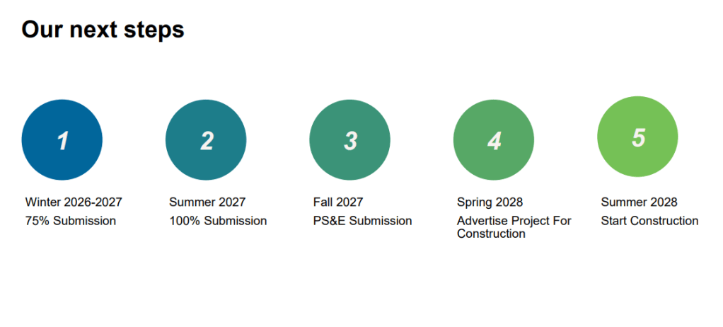
This winter, MassDOT will present the 75 percent design, and the 100 percent design next summer. By this time next year, there will be a Plans, Specifications, and Estimate (PS&E) submission, and construction will be advertised in spring of 2028 and break ground that summer.
More project information can be found here, and comments can be submitted to MassDOTProjectManagement@dot.state.ma.us using the subject line “Design Public Hearing: Project File No. 612263”.
Streetsblog has migrated to a new comment system. New commenters can register directly in the comments section of any article. Returning commenters: your previous comments and display name have been preserved, but you'll need to reclaim your account by clicking "Forgot your password?" on the sign-in form, entering your email, and following the verification link to set a new password — this is required because passwords could not be carried over during the migration. For questions, contact tips@streetsblog.org.