City of Boston Reboots Plans for Bus-Priority Corridor Between North, South Stations
On Thursday afternoon, City of Boston transit planners hosted an in-person open house to discuss its plans for a possible new bus priority corridor that would connect North and South Stations and facilitate faster, more frequent MBTA bus service across downtown Boston.
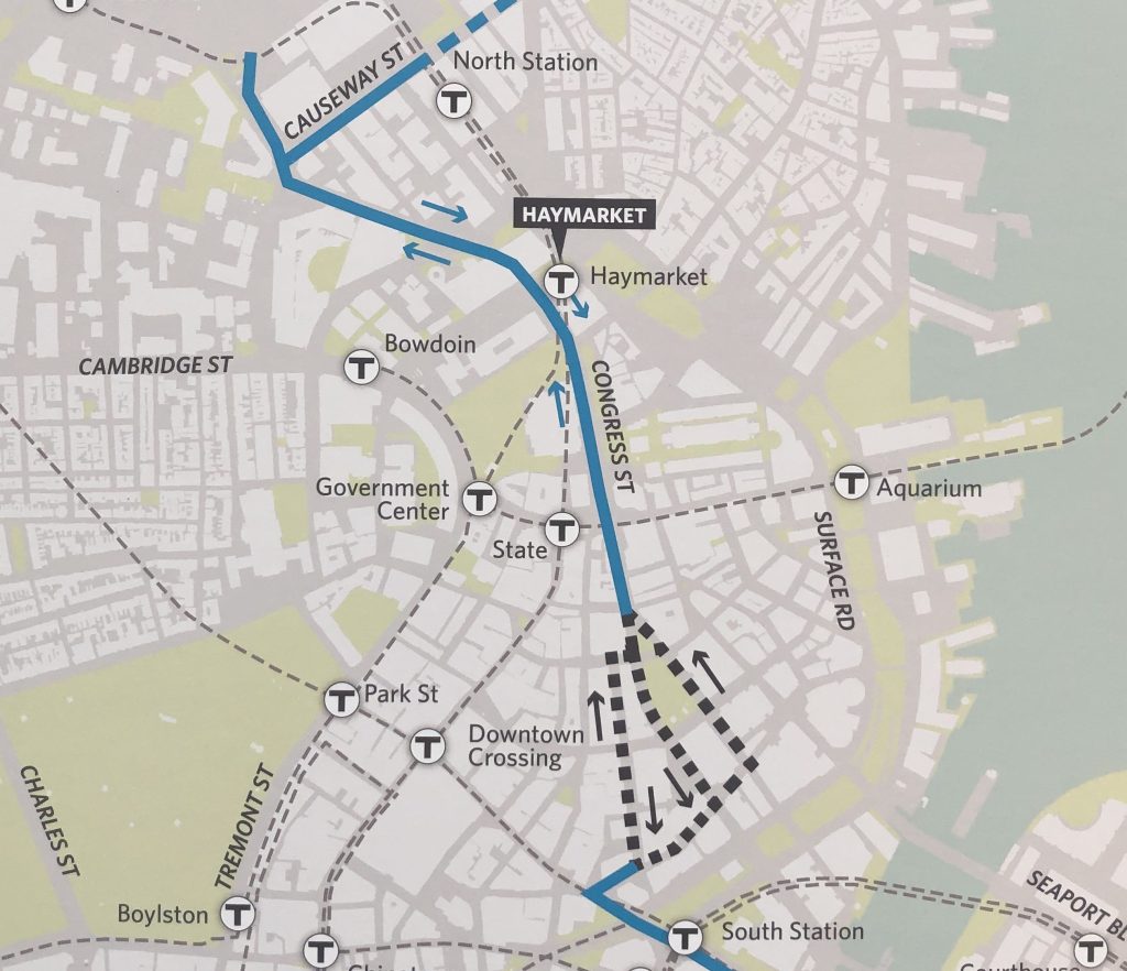
Under the city’s proposed route, which is still subject to refinements, a new “multimodal corridor” would extend from Causeway Street in the North End to Summer Street at Fort Point Channel, via Congress Street (see map above).
In addition to bus-priority infrastructure and enhanced bus stops, the city is also examining the possibilities for cross-town protected bike lanes and safer, more visible crosswalks.
Three route options are being considered for the short section of the corridor between Dewey Square and Post Office Square, where there are currently only one-way streets. The city is considering converting one of those streets to allow two-way bus traffic, or the new bus route could be split along two different streets.
The project is being designed to complement the MBTA’s own Bus Network Redesign efforts, which call for an expanded network of high-frequency bus routes throughout the region, and will rely on a significant expansion of bus lanes and other bus-priority infrastructure to allow faster, more reliable service.
The T’s map of proposed new bus routes won’t be released until mid-May, but City of Boston planners did get permission to share one of the proposed new routes, which would connect Sullivan Square, downtown, the Seaport, and South Boston via the new downtown busway.
The proposed “T-7” route, mapped below, would essentially combine the existing 93, which currently runs from Haymarket to Sullivan Square through Charlestown, with the 7, which runs between downtown Boston and City Point through the Seaport:
In addition to serving a new cross-town bus route, the proposed downtown bus-priority infrastructure could also benefit and expand existing routes to give more riders a one-seat ride to more destinations.
For instance, the 111 bus from Chelsea, which currently terminates at Haymarket, could instead continue through the financial district to South Station, and the Silver Line 4 and 5 buses from Roxbury could run all the way to North Station.
The concept is similar to a “Center City Link” bus priority corridor that the City of Boston had proposed to the MBTA’s governing board in December 2019.
At that time, the T was soliciting potential “demonstration projects” to improve bus service; however, those proposals were shelved when the pandemic hit a few months later. Instead, the MBTA’s bus planners decided to focus their efforts on a more comprehensive redesign of the bus system.
At Thursday’s open house, Boston Transportation Department transit planner Matt Moran told StreetsblogMASS that the city is soliciting architecture firms to design “aspirational and modern” bus stations along the route that would also complement the varied historic contexts of Boston’s downtown neighborhoods.

The city is currently developing conceptual plans for the busway; a more detailed “25 percent” design could be ready in early 2023, which could set the project up for construction in 2024.
Moran said the feedback so far from stakeholders and abutting property owners has been very positive.
“People are excited about this and want to see this connection happen,” he said.

Read More:
Streetsblog has migrated to a new comment system. New commenters can register directly in the comments section of any article. Returning commenters: your previous comments and display name have been preserved, but you'll need to reclaim your account by clicking "Forgot your password?" on the sign-in form, entering your email, and following the verification link to set a new password — this is required because passwords could not be carried over during the migration. For questions, contact tips@streetsblog.org.