Boston Plans New Parkland to Bridge the Turnpike’s Scar Through Chinatown
The City of Boston plans to use $1.8 million in federal funding to design a new park that would cover the Interstate 90 trench and patch over the highway’s “longstanding physical division in Boston’s historic Chinatown.”
As we reported here last week, the U.S. Department of Transportation’s new “Reconnecting Communities” grant program, which the federal government describes as as effort to “reconnect communities that are cut off from opportunity and burdened by past transportation infrastructure decisions,” awarded funding to two planning efforts, in Boston and in North Adams.
StreetsblogMASS has now obtained a copy of the City of Boston’s grant application, which provides additional details about what the city hopes to accomplish with the funding.
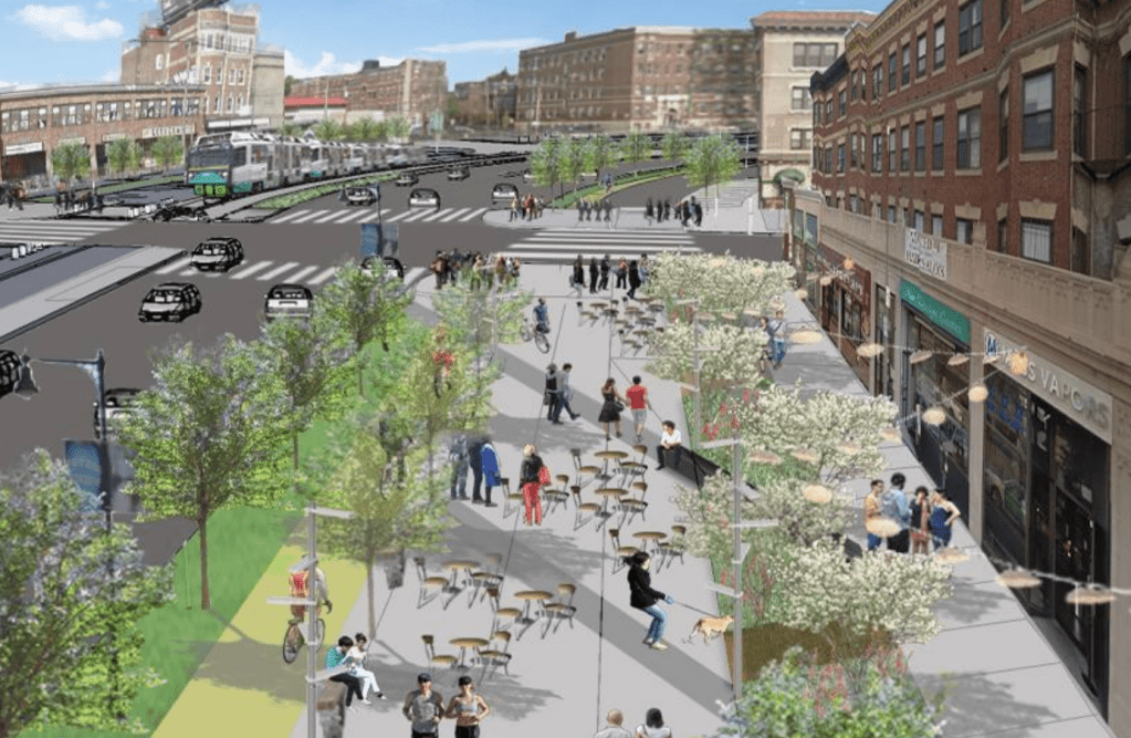
The planning effort will focus on four blocks of the Interstate 90 trench, from Arlington and Tremont Streets in the west to Harrison Avenue in the east, with particular focus on “Parcel 21,” located between Washington Street and Shawmut Avenue:

According to the city’s grant application, the planning funds will be used to “develop a plan to connect across the open-cut highway by building over Parcel 21 to create open space for the community, and prepare design guidelines for Parcels 19, 20, and 22 to link the surrounding streets and facilities.”
Historically, those parcels – along with numerous others along the Turnpike’s scar through Allston, Fenway, and Back Bay – have been envisioned to accommodate new “air rights” developments with new buildings that would be built over the highway and adjacent railroad lines.
In “A Civic Vision for Turnpike Air Rights in Boston,” a 2000 City of Boston planning document, City of Boston planners recommended that the air-rights parcels above the Turnpike between Tremont St. and Harrison Ave. “should be devoted to uses that create diverse housing and job opportunities for these neighborhoods, foster a lively pedestrian-friendly public realm, provide public open space and community facilities, and minimize traffic and other impacts.”
However, because of the high costs and logistical challenges of building over a busy interstate highway, only a small handful of Turnpike air rights projects have actually materialized in the past 50 years.
The city’s new Reconnecting Communities project references the 2000 plan and asserts that “creation of new, affordable housing developments will need to be considered and explored with the community.”
But the grant application also stresses the need for anti-displacement efforts to ensure that existing residents aren’t priced out of the neighborhood as it becomes a more desirable place to live.
The city’s planning effort will also examine adjacent streets, like Marginal Road and Herald Street, which the grant application describes as “in disarray” with “hostile pedestrian environments.”
“This Reconnecting Communities grant would provide funding to assess and understand the street facilities and assets in need of repair and improvement,” according to the city’s application.
Another section of the application says that the plan could recommend “rerouting or redesigning adjacent and proximate roads in the vicinity to accommodate safer mobility options.”

Read More:
Streetsblog has migrated to a new comment system. New commenters can register directly in the comments section of any article. Returning commenters: your previous comments and display name have been preserved, but you'll need to reclaim your account by clicking "Forgot your password?" on the sign-in form, entering your email, and following the verification link to set a new password — this is required because passwords could not be carried over during the migration. For questions, contact tips@streetsblog.org.