Skip to Content
Streetsblog Massachusetts home
Log In
Trails

Somerville’s Community Path Extension Is Open

A view down a straight pathway with a yellow line painted down its center. The path is lined with black fencing and railroad infrastructure is visible to the right. In the distance is a bridge over the tracks and an MBTA station sign, and a skyline of buildings and trees
Photo courtesy of the MBTA|

Somerville’s new Community Path, looking down from the viaduct over the commuter rail tracks into East Somerville.

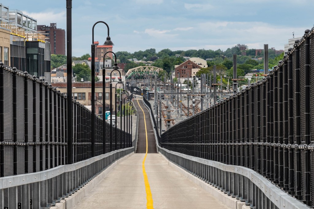
The long-awaited Somerville Community Path Extension will finally open to bike and pedestrian traffic on Saturday, June 10.

The project is the final component of the Green Line Extension project to open to the public. The MBTA announced the opening date in a surprise Friday afternoon press release, after months of delays.

In 2015 and 2016, when estimated costs were spiraling out of control, the MBTA proposed to save money by eliminating the pathway from the project's scope.

But hundreds of local advocates and Somerville elected officials lobbied to keep it in the scope of the project.

The GLX project began construction at the end of 2017. Its two light rail extensions opened in March and December 2022.

The new path runs alongside the new Green Line tracks for a little over two miles. It connects downtown Boston and the Charles riverfront through several Somerville neighborhoods to the Alewife area in Cambridge, where several other popular multi-use trails converge.

A map of Mass. Central Rail Trail projects in the greater Boston region as of spring 2023. Solid black lines indicate existing off-street paths in the Mass. Central Rail Trail network; dotted red lines indicate projects currently under construction: (1), the Waltham Wayside Trail project, and (2), the Somerville Community Path, being built as part of the Green Line Extension project. The dashed gray line marked (3) in Belmont is the first phase of the Belmont Community Path, which could go under construction in 2026.

The path is also a segment in the much longer Mass. Central Rail Trail, a partially-complete 100-mile pathway between Boston and Northampton.

Stay in touch

Sign up for our free newsletter

More from Streetsblog Massachusetts

Roadblocked: Trump’s ‘Big Beautiful Bill’ Eliminates Most Federal Funding For Allston Highway Realignment

Without a formal project agreement in place, MassDOT will receive only $8 million out of a $335 million "reconnecting communities" grant that the Biden administration had pledged.

July 10, 2025

Another Bus Lane Bites the Dust: Wu Administration Forces Chelsea, Charlestown Transit Riders to Wait In More Traffic

The change comes just weeks before the MBTA rolls out a new bus lane enforcement system, which is expected to improve bus service considerably – at least on the dwindling number of streets where dedicated bus lanes still exist.

July 8, 2025

Balanced For Now – But Beacon Hill Is Putting the T Back On the Edge of Another Fiscal Cliff

The state's final budget gives the T about $80 million less than it had planned to spend in the coming fiscal year to cover its payroll and other transit operating costs.

July 7, 2025

Ambulance Data Reveals That Boston Drivers Are 4 Times More Likely to Run Over Pedestrians From Black Neighborhoods

"Overall, residents of predominantly Black and Latino neighborhoods are about four times more likely than residents of predominantly white neighborhoods to be struck as a pedestrian."

July 1, 2025
See all posts