MBTA’s Green Line Accessibility Project Will Consolidate Stops in Brookline

By the end of 2026, Brookline will have two fewer Green Line stops, but riders will get faster transit trips and upgraded stations as part of the T’s efforts to make the C branch fully accessible between Cleveland Circle and Kenmore Square.
The C branch runs along the median of Beacon Street through Brookline from Kenmore Square to Cleveland Circle. As a former streetcar line, most of its stops require riders to step up onto trains from low asphalt platforms next to the sidewalk.
To make these stations compliant with the Americans With Disabilities Act (ADA) and other building codes, the project will widen those platforms and elevate them by 8 inches, which will make them level with the floors on trains.
The changes will also make these stations compatible with the T’s new, longer “Type 10” Green Line trains, which are scheduled to enter service in 2027. As we’ve reported previously, the T is making similar changes to stations on the B branch in Brighton.
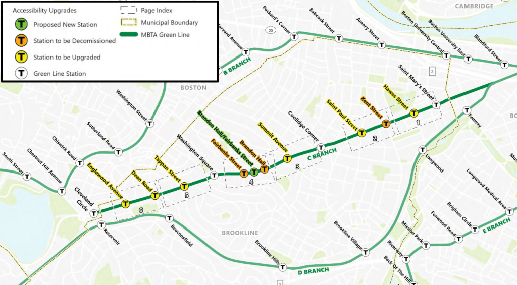
Station consolidation
According to environmental filings that the MBTA published on Monday, the T will also consolidate several C branch stops that are unusually close together as part of this project.
East of Coolidge Corner, the agency plans to eliminate the Kent Street stop, which is located less than 800 feet away from adjacent stops at Hawes Street and St. Paul Street.
Further west, the T is also planning to consolidate two other closely-spaced stops – Brandon Hall and Fairbanks, which are less than 700 feet apart – into a single new station.
The existing Brandon Hall and Fairbanks stations are located on a hillside where the westbound lanes of Beacon Street are about 10 feet higher in elevation than the eastbound lanes and the Green Line tracks.
Currently, passengers heading to and from the neighborhoods to the north access these stations via two public staircases that connect to crosswalks across the elevated section of Beacon Street.
The new, consolidated Brandon Hall/Fairbanks station, which would be located slightly west of the existing Brandon Hall stop, will supplement those stairs with a new ADA-accessible ramp between the westbound station platform and a new crosswalk across the elevated section of Beacon Street:
With two fewer stops, the T forecasts that Green Line trips will get slightly faster. The project’s environmental analysis predicts that riders would save “an average of approximately 31 seconds per passenger” during the morning peak-hour eastbound trips, and “an average of approximately 54 seconds per passenger” in afternoon peak-hour westbound trips.
Funding for the project will come from a $67.6 million Federal Transit Administration grant that the T received earlier this year to upgrade 14 non-accessible stops along the Green Line’s B and C branches.
According to the MBTA’s December accessibility report, the T expects to procure a design-build contractor for these projects within the next few months. Construction would begin next fall, and the T expects to finish the work by late 2026.

Read More:
Streetsblog has migrated to a new comment system. New commenters can register directly in the comments section of any article. Returning commenters: your previous comments and display name have been preserved, but you'll need to reclaim your account by clicking "Forgot your password?" on the sign-in form, entering your email, and following the verification link to set a new password — this is required because passwords could not be carried over during the migration. For questions, contact tips@streetsblog.org.