A Small Central Mass. Town Is Tearing Up A Parking Lot to Make Its Downtown Greener and More Walkable
Athol is, in many respects, a quintessential Massachusetts small town, with a quaint, compact downtown district surrounded by green hills. In the center of the town – geographically and economically – is the Starrett Company, a high-tech precision tools manufacturer that still operates out of its 19th-century brick mill buildings on the banks of the Millers River.
Like so many other cities and towns across the country, Athol also bears scars from ruinous 20th-century land use and transportation policies that hollowed out its walkable Main Street in order to subsidize suburban big-box strip malls.
But Athol is doing more than many of its peers to repair those mistakes and revitalize its downtown with new pedestrian-focused development.
The town is one of only a handful of municipalities in Massachusetts to have repealed minimum-parking mandates in its downtown zoning districts.
And now, the town has also leveraged state funding to rip out several acres’ worth of asphalt from a blighted town-owned parking lot on the edge of its downtown district.
The project aims to replace an eyesore in order to restore stream habitat, reduce flooding, improve pedestrian connections, and beautify its downtown.
Out of a pipe, into a park
The Greening Lord Pond Plaza project is currently under construction and expected to be complete later this year.
Its focus is Lords Pond Plaza, an aging strip mall built sometime in the 1960s.
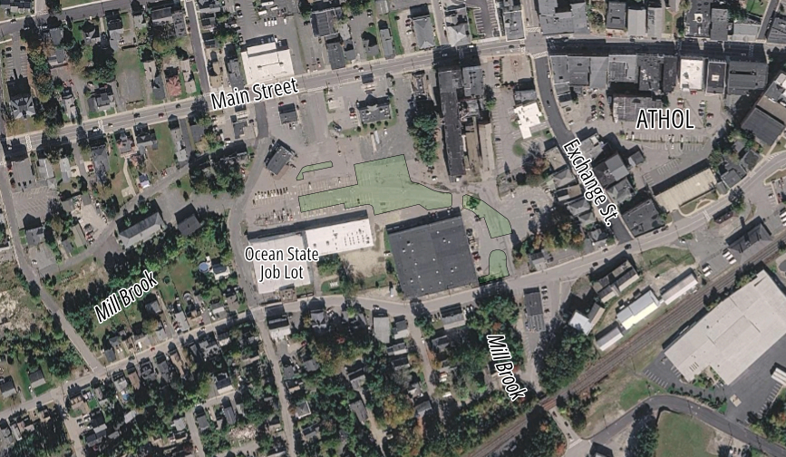
Like many other shopping centers of the era, Lords Pond Plaza cut itself off from Main Street’s historic buildings and small businesses with a massive field of asphalt.
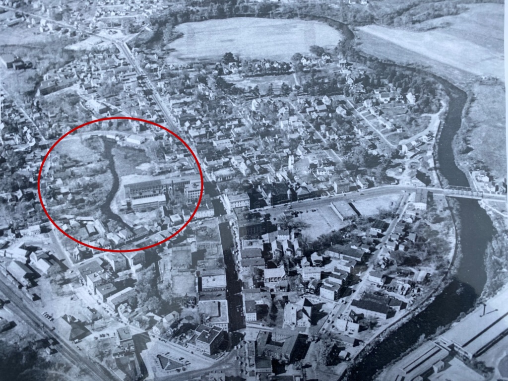
“The stream was put into in a giant culvert sometime in the 1960s,” explains Eric Smith, the Town of Athol’s Director of Planning and Community Development. “It was just like the song, ‘they paved over paradise and put in a parking lot.'”
Smith told StreetsblogMASS that the idea for Athol’s Greening Lord Pond Plaza project has been circulating for more than a decade.
In 2014, Athol partnered with the UMass Amherst planning department to conduct a downtown revitalization study, which raised the idea of “daylighting” Mill Brook through the parking lot in order to transform a downtown eyesore into an attraction.
In 2019 and 2020, the town received planning funds from the Commonwealth’s Municipal Vulnerability Preparedness program, a grant program that helps cities and towns identify and mitigate risks from global heating and extreme weather events.
“Lords Pond Plaza stood out as a significant heat island, almost like a bullseye on a map. And so it was the number one project idea from that process, just trying to daylight the stream and green up the plaza,” Smith said.
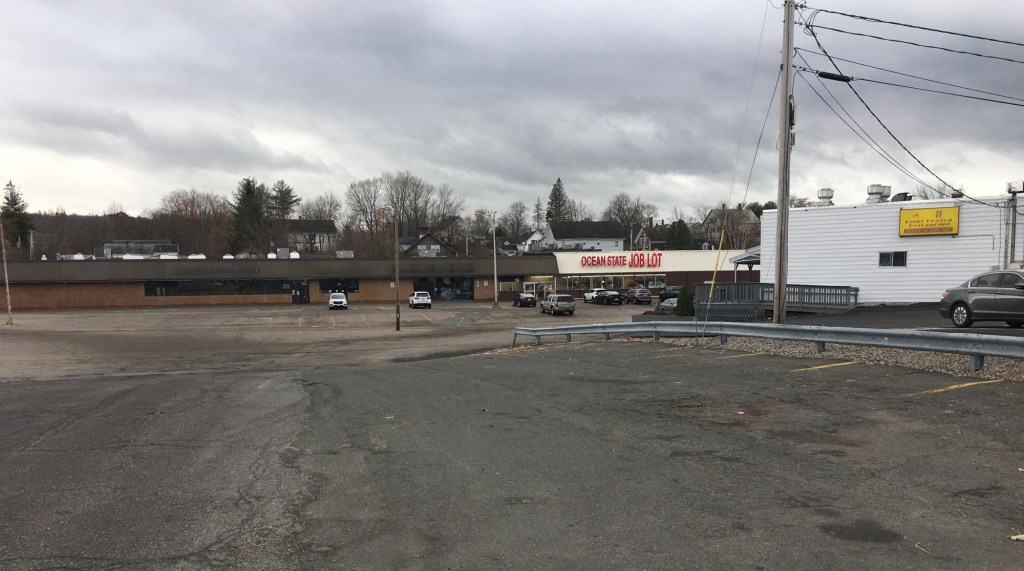
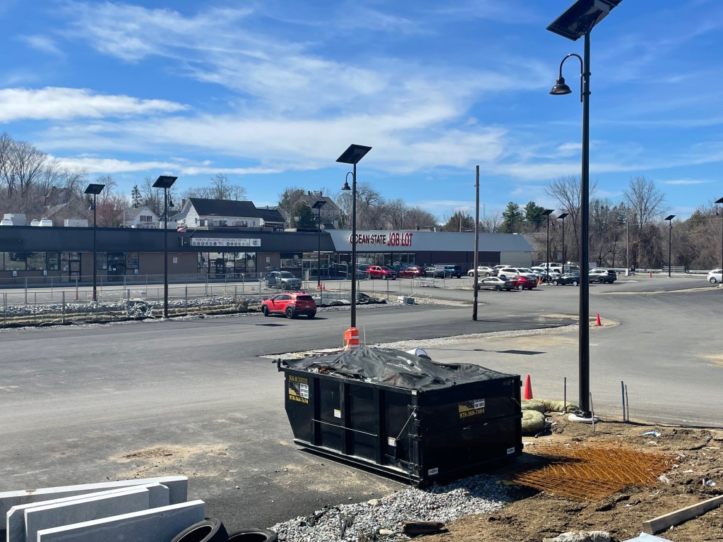
Visiting the plaza today, the strip mall is still there and open for business – it’s got an Ocean State Job Lot, plus a veterans’ community center and offices for the regional chamber of commerce.
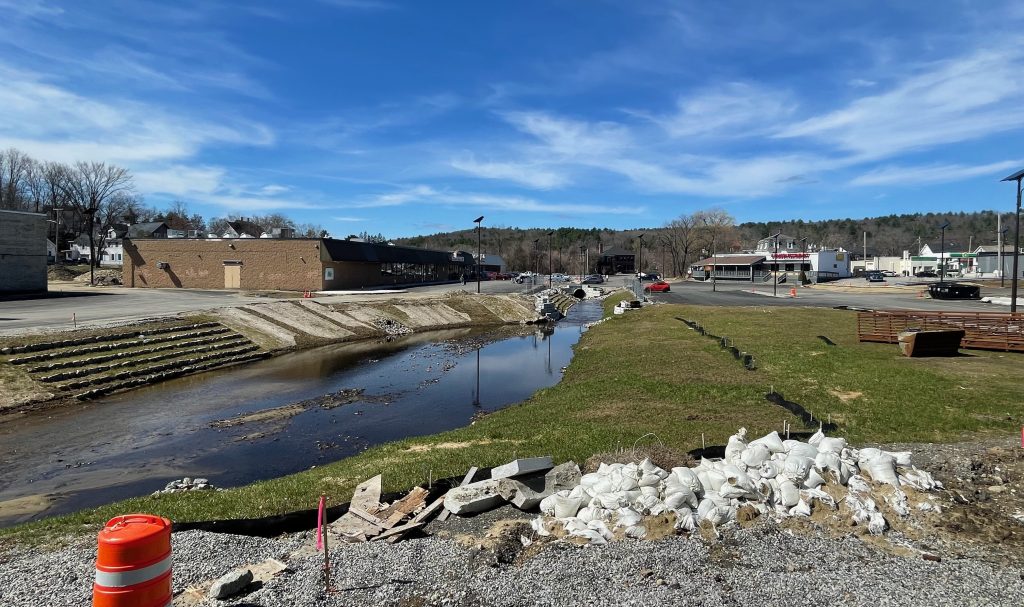
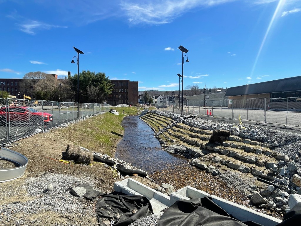
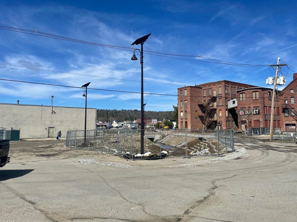
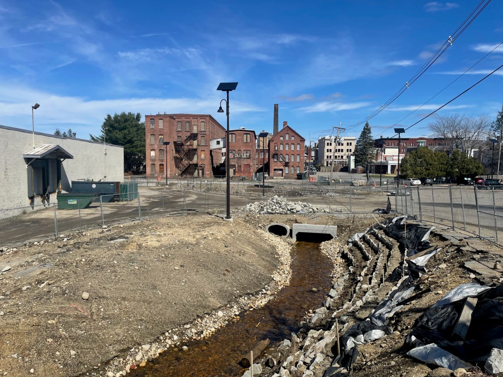
But instead of a vast field of asphalt, there are now rings of construction fencing surrounding large patches of greenery that slope down to a shallow stream bed.
The largest section of green space (pictured above and at the top of this article) is located right in front of the North Quabbin Veterans Center.
Two other sections of daylighted stream bed (pictured below) curve around an adjacent manufacturing building, with connecting culverts that allow for driveway and sidewalk access across the brook.
As work continues this spring and summer, those new stream banks will be planted with meadow plants for pollinators, and new shade trees. The new parkland can hold and absorb a lot more water than the old culvert pipe, which will make Mill Brook and the surrounding neighborhood safer from destructive floods in major storms.
There’s still plenty of parking, too – over 200 spaces have been freshly paved in newly-reconfigured parking lots that flank the stream, and a small segment of Mill Brook will still flow through a pipe in order to preserve about 20 spots in front of the Ocean State Job Lot.
But the new lots set aside space for designated, accessible walkways through the area – including a new pedestrian bridge over the brook.
New tree-planting strips divide the drive aisles to provide some shade, and the project has also installed new streetlights.
Smith hopes that the area will turn into a place where people will want to enjoy themselves.
“There’s space for a farmers’ market, and food trucks,” he says. “We’re certainly hoping that this leads to more opportunities and investment downtown… Hopefully this will spill over.”

Read More:
Streetsblog has migrated to a new comment system. New commenters can register directly in the comments section of any article. Returning commenters: your previous comments and display name have been preserved, but you'll need to reclaim your account by clicking "Forgot your password?" on the sign-in form, entering your email, and following the verification link to set a new password — this is required because passwords could not be carried over during the migration. For questions, contact tips@streetsblog.org.