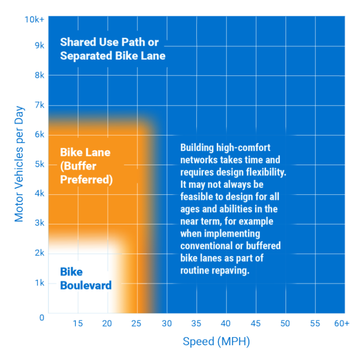
Last month, MassDOT released its new statewide Bicycle Transportation Plan and a separate Statewide Pedestrian Transportation Plan, the culmination of a two-year planning effort organized around the vision of making biking and walking "a safe, comfortable, and convenient option" for everyone in Massachusetts.
The state is also putting some significant money on the table to make sure the plans will be implemented: the state's recently approved 5-year Capital Investment Plan, which includes a new $60 million spending program specifically for the implementation of the plans' initiatives.
The last statewide pedestrian plan was published in the 1990s, and the last bicycle plan, published in 2008, was primarily focused on planning a statewide network of off-road greenways.
Peter Sutton, the State Bicycle and Pedestrian Coordinator at MassDOT, says that the new plans take a much broader view of bicycling and walking as integrated components in the state's transportation system, and benefitted from much broader engagement efforts (the plans' authors attended open streets events, hosted statewide listening sessions, and collected thousands of comments online).
Thanks for over 2,900 #MABikePlan comments! Outreach closes tomorrow. Help us exceed 3,000 comments! https://t.co/SMgkmzScD9 pic.twitter.com/Y81Yqdhvsr
— Mass. Transportation (@MassDOT) October 5, 2017
"The new plans are multifaceted, focused on building out networks and reducing barriers to biking and walking. That includes infrastructure, but we're also looking at maintenance and education as well," said Sutton.
"The new focus is on short trips of 3 miles or less, that’s the sweet spot, over a huge network," said Jackie DeWolfe, MassDOT's Director of Sustainable Mobility. With that lens, the plan developed maps of the entire state to illustrate missing links in areas that would benefit most from better walking and biking infrastructure.
"When we think about regional network planning, it’s a starting point," said DeWolfe. "It shifts the conversation from ‘biking and walking is just a Boston thing,’ to show that there’s potential all over the state."

Because MassDOT controls a relatively small number of roadways statewide, it will be up to local governments to actually make the plan's vision and goals a reality. To that end, MassDOT is offering technical assistance and new funding resources, plus new Municipal Resource Guides for Walkability and for Bikability to help local officials make their own local plans and follow through with high-quality projects.
The resource guides are intended for local advocates, elected officials and municipal staff to plan and advocate for better walking and bicycling facilities on local streets.
Now that the plans are published, MassDOT wants to make sure they’re used.
"We encourage people to actually read them - with two years of work, there was a lot of thought and input,” said DeWolfe. “And then let’s all work collaboratively to get them implemented.“


