Skip to Content
Streetsblog Massachusetts home
Log In
Bicycling

Ruggles Street Plans Aim for Safer Link From Dudley Square to SW Corridor

A rendering of the proposed Ruggles Street improvements illustrate new bike lanes, shortened, raised crosswalks, and increased sidewalk space for pedestrians and bus riders. The planned reconstruction project is scheduled to begin in 2020. Courtesy of the City of Boston.

A rendering of the proposed Ruggles Street improvements illustrate new bike lanes, shortened, raised crosswalks, and increased sidewalk space for pedestrians and bus riders. The planned reconstruction project is scheduled to begin in 2020. Courtesy of the City of Boston.

The City of Boston Public Works Department is finalizing plans to rebuild Ruggles Street, a street lined with affordable housing developments, with narrower car lanes, wider sidewalks and new protected bikeways.

The project spans only about 2,000 feet of roadway, but it is bookended by two major transit destinations: the Ruggles T stop and the Southwest Corridor paths to the north, and, to the south, to Dudley Square's commercial district and bus station.

In between, Ruggles Street passes through two major affordable housing neighborhoods, including the Whittier public housing complex, which is in the midst of a major redevelopment that will bring hundreds of new homes to the area.

In that section, Ruggles is currently a very wide one-way street, and residents report that wrong-way driving and high vehicle speeds are common.

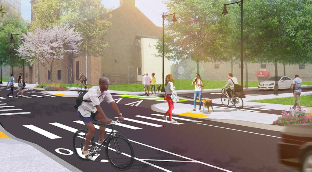
To improve safety, the city is proposing to narrow the street by designating new dedicated lanes for bicyclists – including a protected, sidewalk-level westbound bike lane – and add new curb extensions to reduce crossing distances for pedestrians.

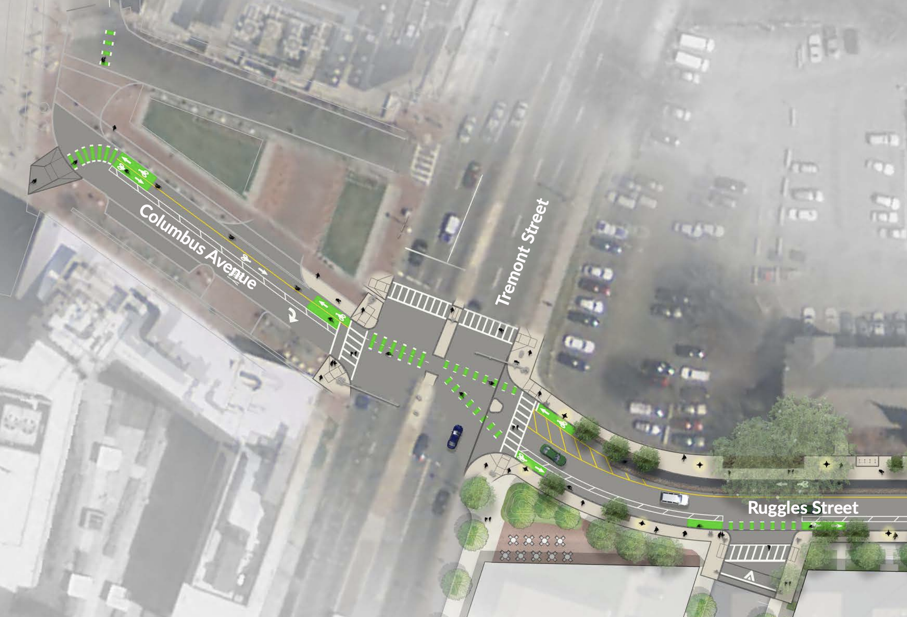
The city is also planning a two-way bikeway connection across Tremont Street to connect the improved street to the T station and Southwest Corridor path:

A plan view of the new Ruggles Street at Tremont, where cyclists will be able to access a new 2-way bikeway link to the Southwest Corridor path and the Ruggles Orange Line stop.  Courtesy of the City of Boston.
A plan view of the new Ruggles Street at Tremont, where cyclists will be able to access a new 2-way bikeway link to the Southwest Corridor path and the Ruggles Orange Line stop. Courtesy of the City of Boston.

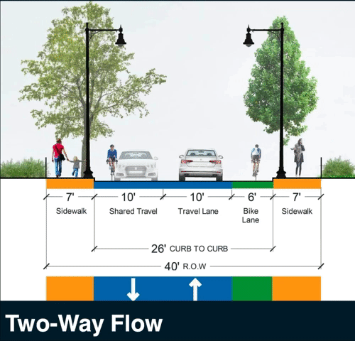
For the block east of Shawmut, where Ruggles Street occupies a narrower right-of-way, city officials are still evaluating two possible cross-sections. One alternative would leave most of the street available for two-way car traffic, with a contraflow bike lane added, while a second option would reduce car access to set aside space for bike lanes in both directions.

The city is still accepting public feedback on these two alternatives, and the public can weigh in by emailing comments to pwdengineering@boston.gov:

City officials are accepting public input about the narrower section of Ruggles Street between Shawmut and Washington, which could either accommodate 1-way vehicular traffic with protected bike lanes in both directions, or 2-way traffic for cars and one unprotected westbound bike lane. Courtesy of the City of Boston.

A separate project, currently under construction, is adding additional safety improvements to the Dudley Square area in the vicinity of the neighborhood's branch library, which is scheduled to reopen in 2020 after its own extensive renovation project.


Submit feedback:

City of Boston: Ruggles Street reconstruction project information

Submit comments to PWDENGINEERING@boston.gov

Stay in touch

Sign up for our free newsletter

More from Streetsblog Massachusetts

Roadblocked: Trump’s ‘Big Beautiful Bill’ Eliminates Most Federal Funding For Allston Highway Realignment

Without a formal project agreement in place, MassDOT will receive only $8 million out of a $335 million "reconnecting communities" grant that the Biden administration had pledged.

July 10, 2025

Another Bus Lane Bites the Dust: Wu Administration Forces Chelsea, Charlestown Transit Riders to Wait In More Traffic

The change comes just weeks before the MBTA rolls out a new bus lane enforcement system, which is expected to improve bus service considerably – at least on the dwindling number of streets where dedicated bus lanes still exist.

July 8, 2025

Balanced For Now – But Beacon Hill Is Putting the T Back On the Edge of Another Fiscal Cliff

The state's final budget gives the T about $80 million less than it had planned to spend in the coming fiscal year to cover its payroll and other transit operating costs.

July 7, 2025

Ambulance Data Reveals That Boston Drivers Are 4 Times More Likely to Run Over Pedestrians From Black Neighborhoods

"Overall, residents of predominantly Black and Latino neighborhoods are about four times more likely than residents of predominantly white neighborhoods to be struck as a pedestrian."

July 1, 2025
See all posts