A Walk Audit of Worcester
If Worcester has ambitions to become a more walkable, transit-oriented city, streets like West Boylston Street in the city’s Indian Lake neighborhood – a bit over a mile north of downtown – present a major obstacle.
West Boylston Street was historically the main road leading north of the city towards its eponymous suburb. Then, in the 1970s, Massachusetts paved over the eastern shoreline of Indian Lake to build Interstate 190, a 20-mile freeway to Leominster, and turned West Boylston Street into a high-speed, one-way, multi-lane off-ramp.
In spite of that trauma, there are still remnants of the neighborhood business district that existed here before the freeway: the street is still lined with triple-deckers and a handful of neighborhood-oriented small businesses.
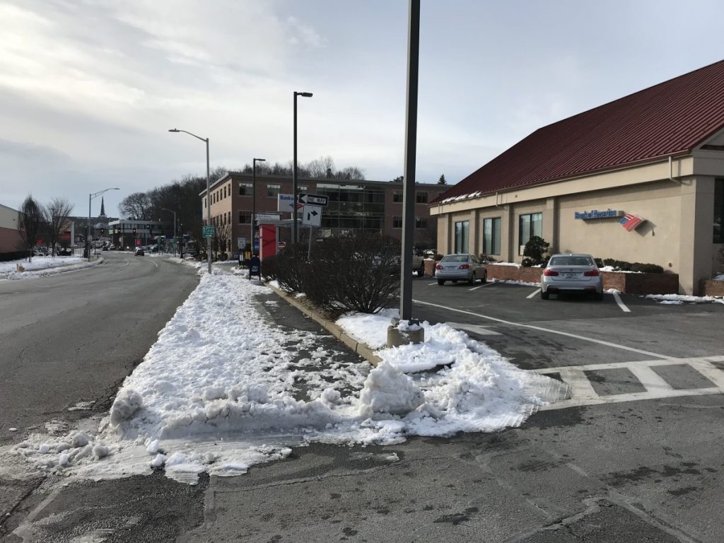
But a half-century’s worth of freeway traffic has also left its mark. Newer bank buildings, the CVS pharmacy, and the Shaw’s supermarket all turn their backs on West Boylston Street’s sidewalks with drive-through lanes and huge parking lots. There are more gas stations and auto repair shops than there are places to buy a gallon of milk or a cup of coffee.
Crosswalks are rare, and even where they exist, they’re dangerous: the street’s two lanes of one-way traffic invite impatient drivers (and there are lots of them) to swerve around any motorist who’s courteous enough to yield to a pedestrian in a crosswalk.
In some places, the highway engineers responsible for West Boylston Street have failed to provide any crosswalks whatsoever:
These photographs were all taken last December, for a virtual “walk audit” for the Indian Lake neighborhood that was hosted by WalkBoston, a statewide pedestrian advocacy organization, and WalkBike Worcester, a local advocacy group.
WalkBoston hosts walk audits all over the Commonwealth. Typically, they bring groups of people together to identify hazards and obstacles to foot traffic in a specific street of neighborhood. Since the pandemic began, WalkBoston has been conducting audits virtually, by sending advocates out to evaluate areas individually, collecting their findings via online forms, and discussing the results in group Zoom meetings.
“Even if what you’re seeing is depressing, the process is a tool to bring people together and build capacity and community assets to produce positive outcomes over the long run,” said LeighAnne Taylor, WalkBoston’s Program Manager and organizer of the Indian Lake event, in a phone conversation with Streetsblog after the walk audit. “Taking an inventory of all the issues is tedious, but it gives people an opportunity to make things happen when grants become available.”
Notwithstanding the challenges, a few Indian Lake residents have big ambitions for their neighborhood to become a more walkable, vibrant place.
One of the most optimistic participants in the walk audit was Carl Gomes, who’s been advocating to turn a vacant lot squeezed between the interstate and the east shore of Indian Lake (locally referred to as “Parcel 149”) into a new waterfront park, and the keystone piece of an envisioned 4-mile trail around Indian Lake.
“149 can be the crown jewel of the entire Worcester parks system,” said Gomes at the Indian Lake walk audit’s second Zoom meeting. “If 149 becomes an activated greenspace, with picnicking and community gardens and docks for sailboats and kayaks… the potential for it is limitless.”
Stephen Rolle, the City of Worcester’s Assistant Chief Development Officer, is aware of the walk audit’s findings and broadly agrees with its assessments – he compared West Boylston Street to “the end of a nozzle with that off-ramp coming off I-190” in a recent phone conversation with Streetsblog.
According to Rolle, one of advocates’ best opportunities to initiate meaningful changes in the neighborhood could come later this year, when the city begins work to update its citywide master plan.
The City of Worcester also has a complete streets policy, but has yet to write a formal implementation plan, which would make the city’s highest-priority safety projects eligible for funding under MassDOT’s Complete Streets program.
Rolle says that the city also hopes to initiate that planning process soon.

Read More:
Streetsblog has migrated to a new comment system. New commenters can register directly in the comments section of any article. Returning commenters: your previous comments and display name have been preserved, but you'll need to reclaim your account by clicking "Forgot your password?" on the sign-in form, entering your email, and following the verification link to set a new password — this is required because passwords could not be carried over during the migration. For questions, contact tips@streetsblog.org.