Gov. Healey’s Environmental Bond Bill Would Surrender Dept. of Conservation ‘Parkways’ to State Highway Agency
Governor Healey is proposing legislation that would transfer several large, albeit heavily-paved parks from the state’s conservation agency to MassDOT.
The language is embedded in the Governor’s proposed Mass Ready Act, also known as the environmental bond bill.
Most of the bill’s text would give the Governor permission to borrow up to $3 billion for infrastructure projects, many of which are aimed at mitigating the risks of rising seas and a heating climate.
But the bill would also transfer several parkways from the custody of the Department of Conservation and Recreation (DCR) to the Commonwealth’s biggest polluter, MassDOT.
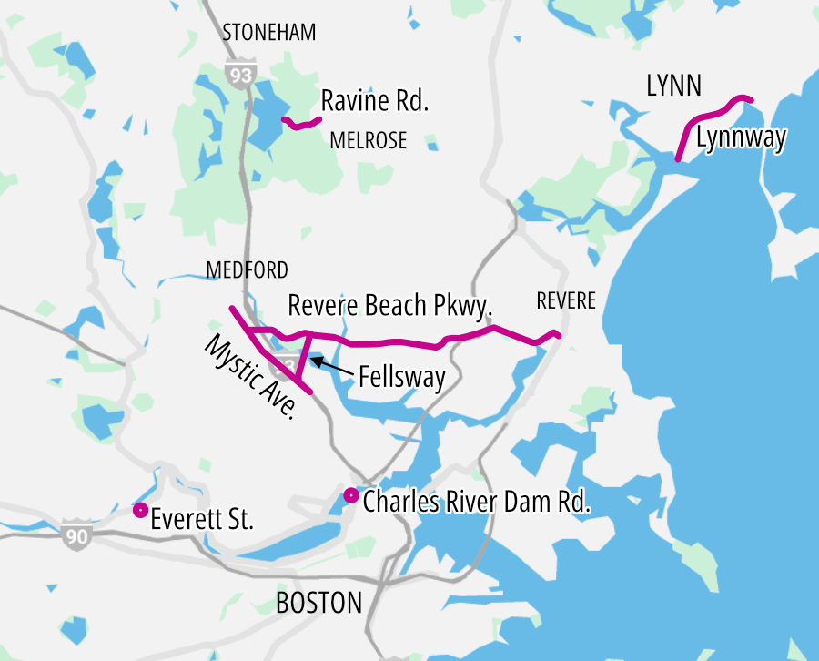
Section 65 of the bill stipulates that “the Department of Conservation and Recreation shall transfer the care, custody and control of the following parkways to the Massachusetts Department of Transportation”:
- Charles River Dam Road in the cities of Boston and Cambridge;
- Revere Beach Parkway (Route 16), including Wellington Circle, from Interstate 93/Route 38 in the city of Medford to the intersection with Route 145 (Winthrop Avenue)/Route 1A in the city of Revere;
- The Fellsway from Wellington Circle to its intersection with Interstate 93 in the cities of Medford and Somerville;
- Mystic Avenue in the city of Somerville;
- The Lynnway in the city of Lynn.
- Medford Veterans’ Memorial Highway in the cities of Medford and Somerville (editor’s note: this appears to be a segment of Route 16 that is also described in the second bullet: Chapter 304 of the Acts of 1950 designated “the highway running over the Mystic marshes from the intersection of Harvard Street and Mystic Avenue to Wellington Circle” in Medford as the Medford Veterans’ Memorial Highway).
Additionally, the bill would also authorize the transfer of two smaller streets from the DCR to municipal control:
- Ravine Road in Stoneham, between Fellsway East to the town line, to the town of Stoneham;
- Ravine Road in Melrose, between West Wyoming Avenue to the town line, to the town of Melrose;
- Everett Street in the Allston-Brighton neighborhood to the city of Boston.
Language in the bill further stipulates that “the exact boundaries” of each of these parkways “shall be determined by the commissioner of capital asset management and maintenance.”
Mission abandoned
Both the Fellsway and the Revere Beach Parkway were originally designed by the famous Olmsted Brothers landscape architecture firm, and both are listed in the National Register of Historic Places.
In the Olmsteds’ original plans, these roadways were modest, two-lane carriage roads lined with allées of trees, designed to be regional extensions of Boston’s Emerald Necklace for the region’s new Metropolitan Park System.
A spokesperson for the DCR, whose mission is to “protect, promote and enhance our common wealth of natural, cultural and recreational resources,” told StreetsblogMASS last week that these parkways “no longer served a park purpose.”
“While the roads are often near a DCR property, their main objective is to serve the local public or high-volume traffic, not to provide access to a park or natural resource,” the spokesperson said.
They added that MassDOT and DCR already have an existing administrative agreement for MassDOT’s Highway Division to maintain most of these roads.
A path to improvement
For several advocates for safer streets, though, the proposed transfer could have a big potential upside.
“The DCR doesn’t do a good job following any vision zero or complete streets practices, mainly because they’re not beholden to,” said Galen Mook, executive director of MassBike.
MassDOT, on the other hand, requires safe walking and biking facilities in major roadway projects, and as an agency, it also has more organizational capacity to manage those projects.
Karl Alexander, the Greenways Program Senior Manager for the Mystic River Watershed Association, notes that MassDOT has had a much more active role in recent years advancing safety upgrades along the Mystic River, including its proposed Main Street safety improvements near Medford Square and ongoing safety upgrades where the Fellsway intersects with Mystic Ave. in East Somerville.
“We believe a formal transfer of roadway ownership would allow DCR to focus more on its conservation and recreation mission for adjacent open spaces in the Mystic River Reservation, reducing duplicated efforts with MassDOT,” Alexander wrote to StreetsblogMASS in an email last week.
Other conservation advocates counter that DCR has never received enough state funding or political support to redesign its parkways as safer streets.
At a July 24 meeting of the DCR’s Stewardship Council, Laura Jasinski, Executive Director of the Charles River Conservancy, asked her colleagues whether the proposal is “penalizing the agency for not having the resources to adequately care for the parkways.”
Mook suggests that the language of the legislation could be amended to make more explicit the parkways’ role in reducing regional traffic pollution and enhancing access to adjacent conservation lands.
“My main concern is that the DOT can claim to focus solely on throughput and not recreation, and the DOT hasn’t shown they have a plan to tangibly reduce vehicle miles traveled,” as required by the state’s climate laws, says Mook.
“I would like to see the ‘park’ nature of these roads guaranteed in the language of the transfer,” Mook suggested.

Read More:
Streetsblog has migrated to a new comment system. New commenters can register directly in the comments section of any article. Returning commenters: your previous comments and display name have been preserved, but you'll need to reclaim your account by clicking "Forgot your password?" on the sign-in form, entering your email, and following the verification link to set a new password — this is required because passwords could not be carried over during the migration. For questions, contact tips@streetsblog.org.