Skip to content

Eyes On the Street: Somerville’s ‘Corridor of Death’ Gets Less Deadly
Drivers haven't killed anyone in the "Corridor of Death" since 2021, and the number of driver-inflicted injuries in the area has declined nearly 80 percent since 2021, according to MassDOT crash data.
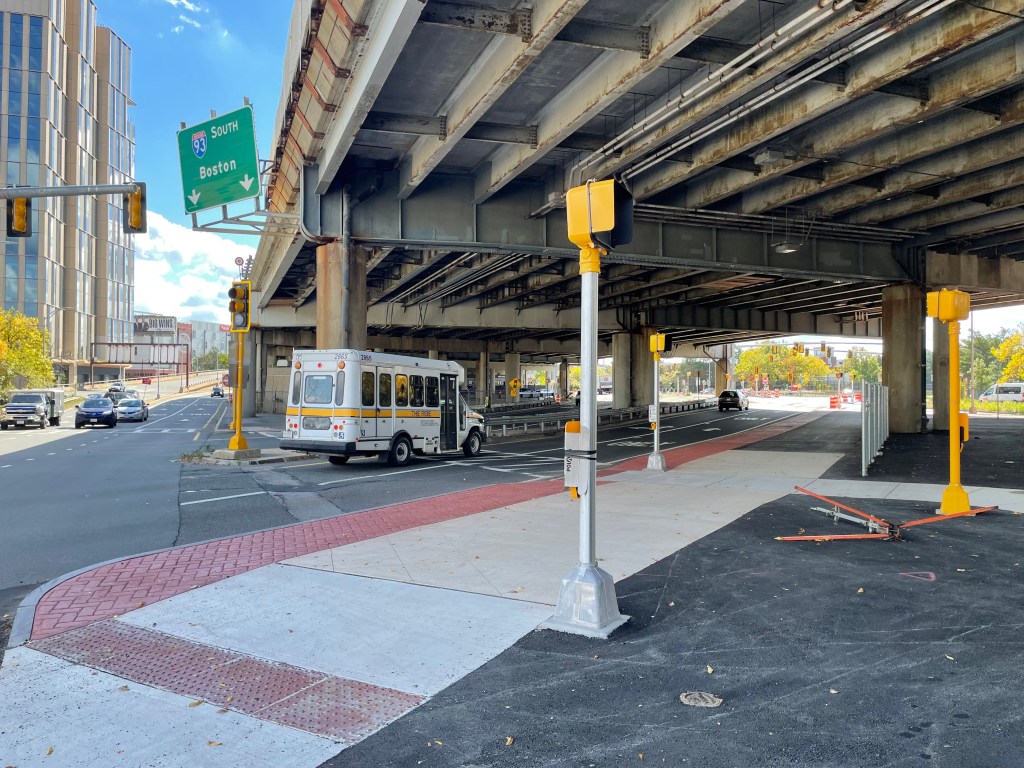
A wide, 15-foot-side concrete sidewalk runs diagonally under a wide, aging highway viaduct next to a multi-lane roadway where an MBTA The Ride van is driving A green highway sign above reads "93 South Boston" above two downward-pointing arrows. On the left edge of the photo is a high-rise building.
A new shared-use pathway connects the Ten Hills neighborhood to the Stop and Shop and Foss Park under the I-93 viaduct. The widened sidewalk replaces what had formerly been a third motor vehicle lane on the adjacent roadway.

The complicated junction of Mystic Avenue, McGrath Highway, the Fellsway, and their various connecting on- and off-ramps to Interstate 93 have historically been one of the most dangerous places in Somerville, to the point where neighbors started calling it the “corridor of death.”

In summer 2019, drivers killed Cheryl Pauline Richards, a 52-year-old Somerville resident, and Kevin Dumont, aged 68, at two different Mystic Avenue crosswalks.

In April 2021, another hit-and-run driver struck and killed Marshall Mac, a 72-year-old Vietnam War veteran and grandfather, while he was trying to cross McGrath Highway at Blakeley Avenue.

In May 2021, dozens of neighbors and elected officials, including U.S. Rep. Ayanna Pressley, gathered at an abandoned gas station next to McGrath Highway to demand that MassDOT address the area’s serious safety problems.
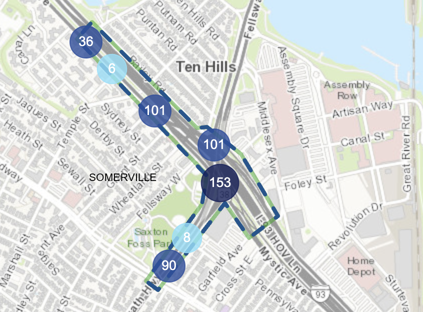
A map of part of Somerville, with the Assembly district on the east (right edge) and the Mystic River to the northeast (upper right). Interstate 93 runs diagonally from upper left to lower right. A T-shaped area in the middle highlights the junction of Mystic Avenue (which runs alongside I-93) and McGrath Highway. Numbered circles indicate the number of crashes in various locations around the highlighted area, with 153 crashes near the intersection of McGrath and Mystic Ave. just to the south of I-93 and a slightly smaller circle labelled 101 just to the north, at the intersection of the Fellsway and Mystic. Another hotspot labelled "90" is near the junction of McGrath and Broadway near the lower (southern) edge of the map.
A crash heatmap of the “corridor of death” area in Somerville. Numerals indicate the total number of crashes in each area from 2019 to Oct. 15, 2026. Courtesy of MassDOT’s IMPACT crash database.

To their credit, MassDOT responded: the agency fast-tracked several of their planned safety upgrades, including a crosswalk where Mac was killed at Blakeley Avenue. By 2022, the agency had also finished new sidewalks and curb ramps along Mystic Avenue, as well as new raised crosswalks, lights, and median islands to improve pedestrian safety at the Kensington Street underpass.

At the same time, the agency was also revising its designs for a larger, federally-funded safety project that it had been planning since 2020.

In its original plans, that project had been mostly focused on upgrading traffic lights and building basic accessibility upgrades to sidewalks and crosswalks, with little in the way to address dangerous driving.

By 2023, though, that project’s designs had become considerably more ambitious, with a larger budget to match. MassDOT’s updated plans for the area called for eliminating motor vehicle lanes on McGrath Highway and adding a network of shared-use paths and protected bike lanes through the area.

That $10.5 million project is now well under construction, with a targeted completion in 2027.

According to data from MassDOT’s IMPACT crash database, the work is already making a difference.

Drivers haven’t killed anyone in the “corridor of death” since 2021. And the number of driver-inflicted injuries in the area has plummeted nearly 80 percent since 2021.
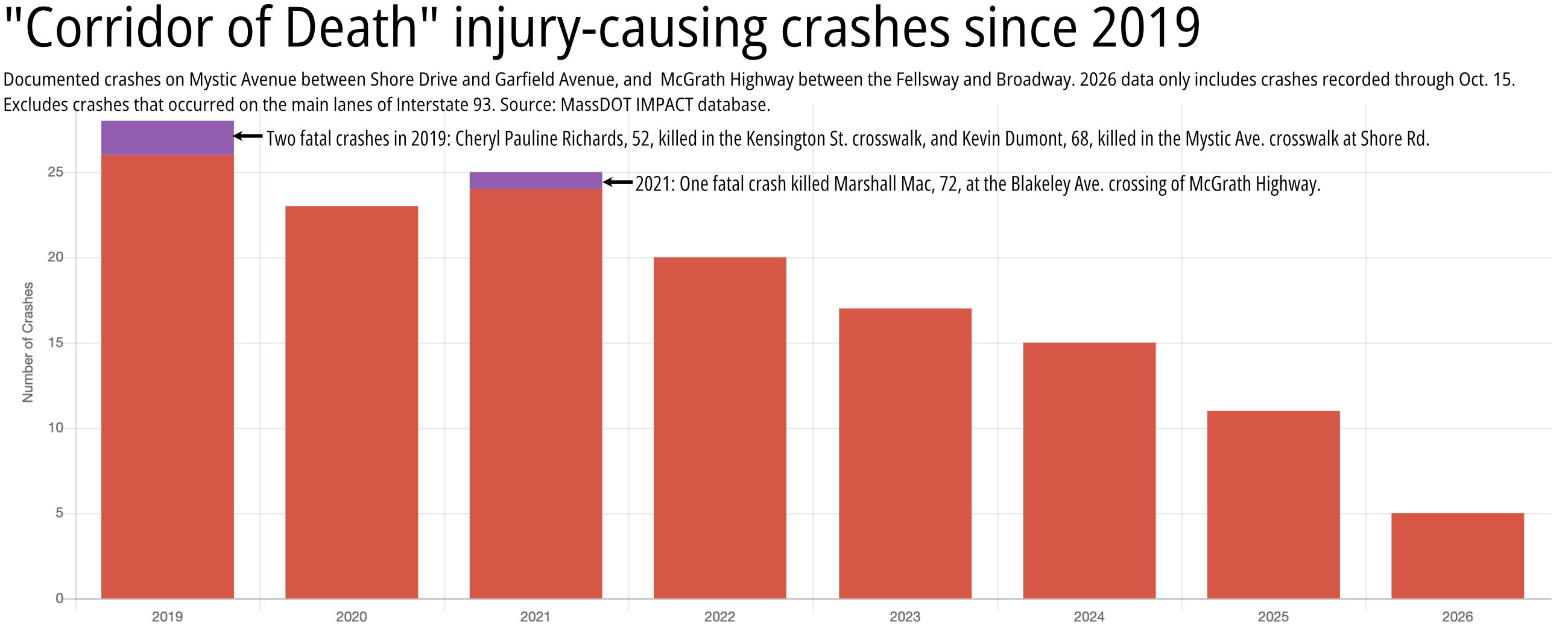
A chart labelled "Corridor of Death crash incidents since 2019" with the subtitle "documented crashes on Mystic Ave. between Shore Drive and Garfield Ave. and McGrath Highway between the Fellsway and Broadway. 2026 data only includes crashes recorded through Oct. 15. Excludes crashes that occurred on the main lanes of I-93." The chart shows the years 2019-2026 on the x axis and the number of crashes, 0 to 30, on the y axis. The bars for each year hover decline from 28 in 2019 to 25 in 2021, then start declining steadily to around 5 in 2026 (to date). Purple bars on top of the 2019 and 2021 columns indicate fatal crashes - 2 in 2019 and 1 in 2021. A label for the 2019 column reads "two fatal crashes in 2019: Cheryl Pauline Richards, 52, killed in the Kensington St. crosswalk, and Kevin Dumont, 68, killed in the Mystic Ave. crosswalk at Shore Rd." A caption next to the 2021 column reads "One fatal crash in 2021 killed Marshall Mac, 72, at the Blakeley Ave. crossing of McGrath Highway."
Source: MassDOT IMPACT database.
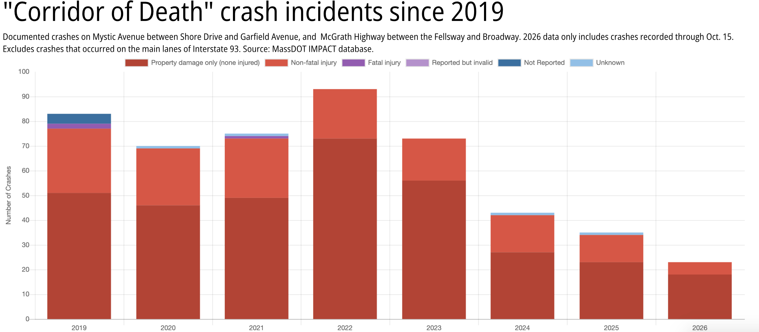
A chart labelled "Corridor of Death crash incidents since 2019" with the subtitle "documented crashes on Mystic Ave. between Shore Drive and Garfield Ave. and McGrath Highway between the Fellsway and Broadway. 2026 data only includes crashes recorded through Oct. 15. Excludes crashes that occurred on the main lanes of I-93." The chart shows the years 2019-2026 on the x axis and the number of crashes, 0 to 100, on the y axis. The bars for each year hover around 80-100 for the first four years, then start declining steadily to around 25 for 2026.
Data courtesy of MassDOT’s IMPACT crash database.

More space for people, less space for reckless driving

StreetsblogMASS visited the area twice this month to document some of the changes.

One of the most visible new features is a new north-south shared-use path that extends alongside the Fellsway and McGrath Highway, from Puritan Road in the Ten Hills neighborhood, under I-93, and along the edge of Foss Park:
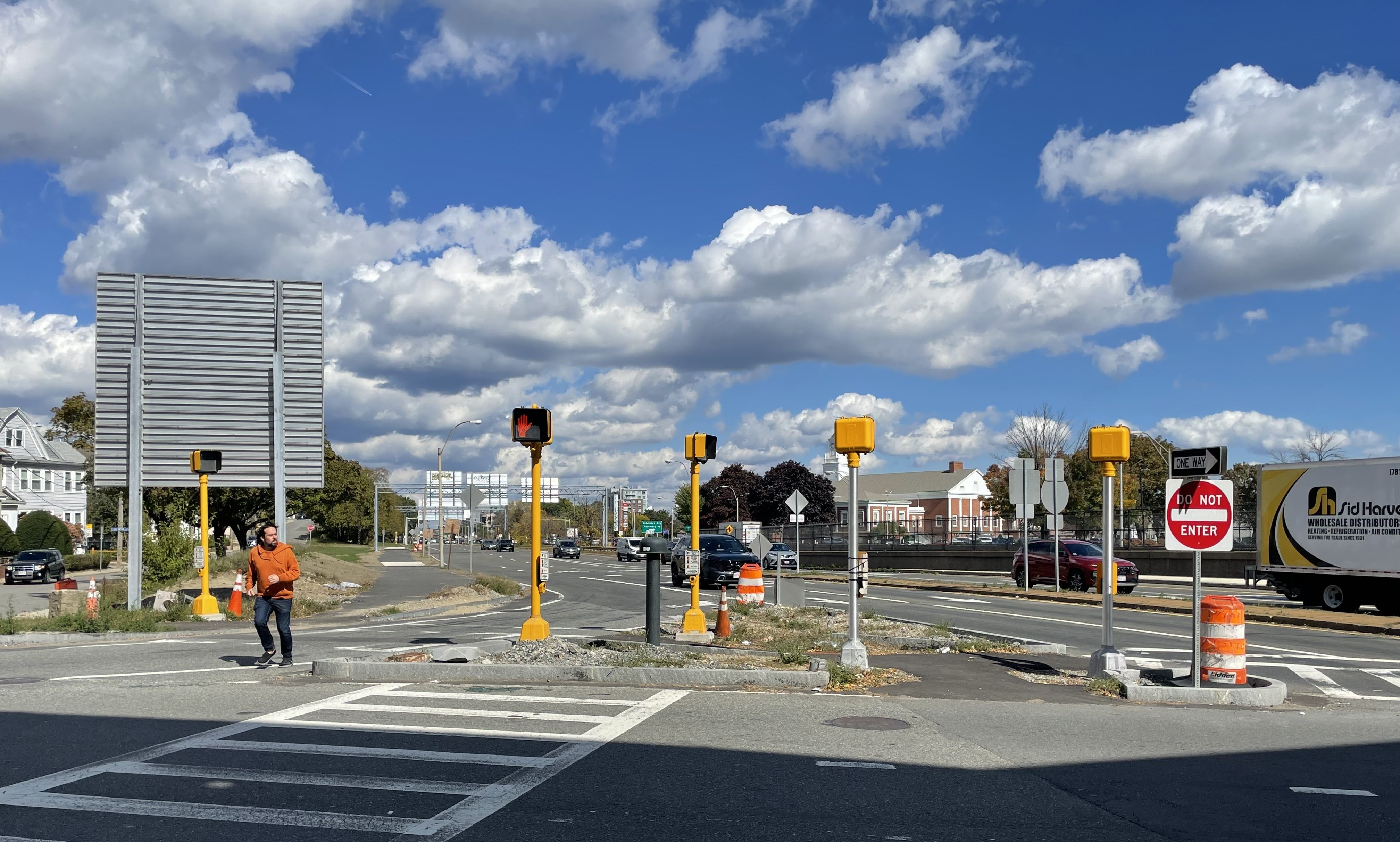
A triangular traffic island is studded with four pedestrian signals in the middle of a wide intersection between two wide multi-lane streets. To the left, a man in a red jacket is in the middle of jogging across the multi-lane roadway in the foreground. Behind him is the grey back side of a large highway sign, approximately 12 feet wide and tall.
A widened island in the intersection of the Fellsway and Mystic Avenue’s westbound lanes, at the edge of the Ten Hills neighborhood in Somerville. A widened 10-foot shared-use path runs along the Fellsway towards Puritan Road in the distance.

This new pathway occupies the space that had previously been a third southbound motor vehicle lane. In 2022, MassDOT repaved most of McGrath Highway south of Broadway with just two lanes in each direction, which made a third southbound lane here unnecessary:
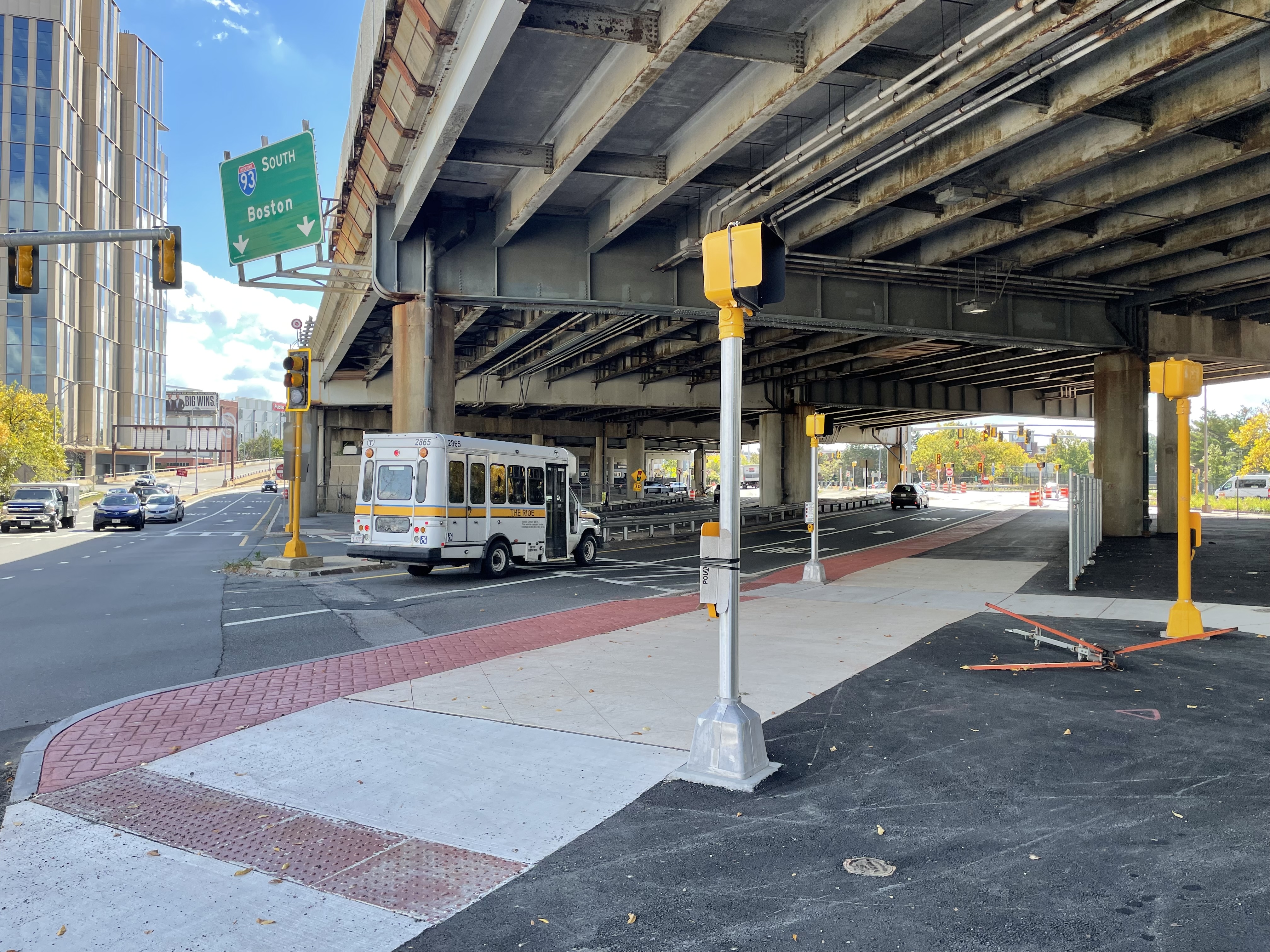
A wide, 15-foot-side concrete sidewalk runs diagonally under a wide, aging highway viaduct next to a multi-lane roadway where an MBTA The Ride van is driving A green highway sign above reads "93 South Boston" above two downward-pointing arrows. On the left edge of the photo is a high-rise building.
A new shared-use pathway connects the Ten Hills neighborhood to the Stop and Shop and Foss Park under the I-93 viaduct. The widened sidewalk replaces what had formerly been a third motor vehicle lane on the adjacent roadway.

The 10-foot-wide shared-use pathway continues along the edge of Foss Park as far south as the Blakeley Avenue crosswalk.
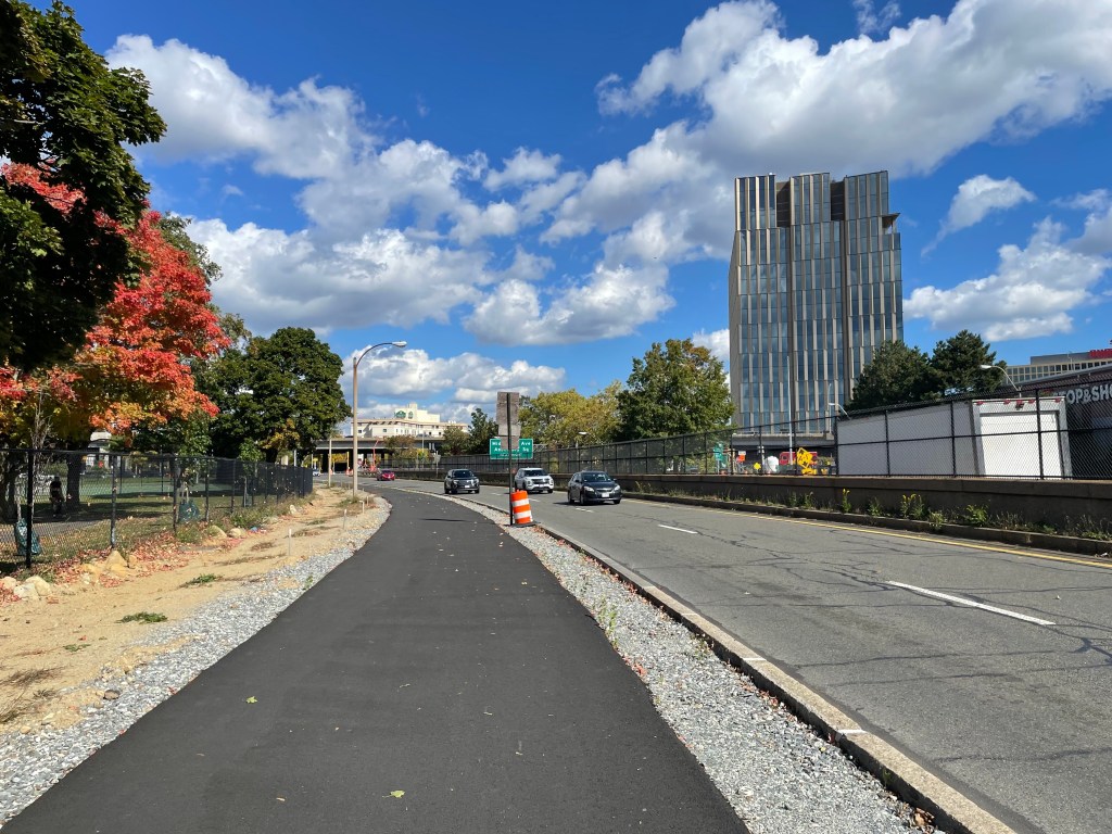
A newly-paved 10-foot pathway runs next to a city park (left) and a two-lane roadway with three cars. In the distance is a high-rise building.
A new shared-use path next to McGrath Highway (whose southbound lanes are at right) and Foss Park (left).

South of Blakeley Avenue, the separated path transitions to a narrower sidewalk that will run alongside a sidewalk-level protected bike lane.
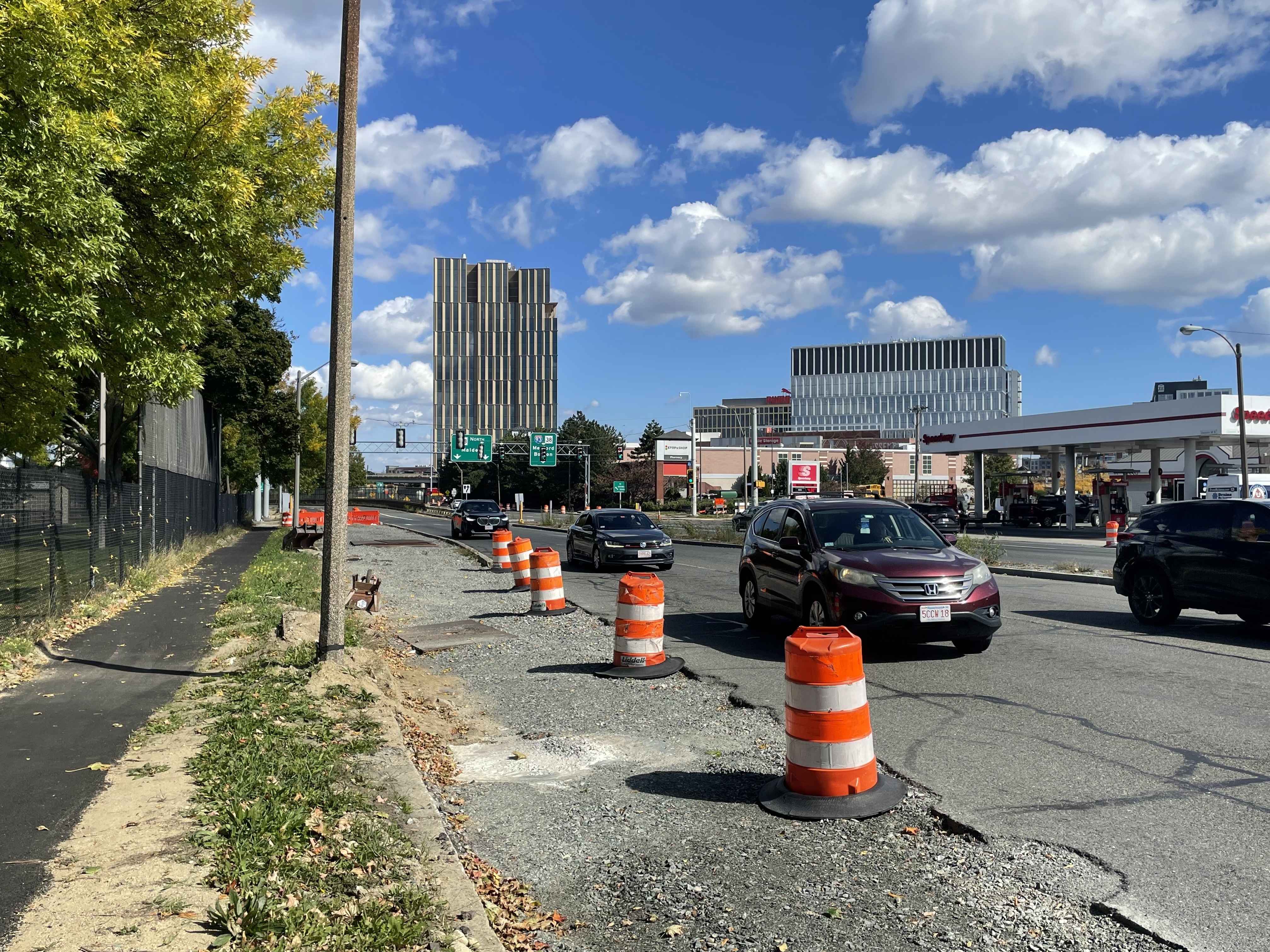
A photo of a wide multi-lane street lined with orange construction cones (right) next to a park with trees (at left). In the foreground a strip of gravel lies parallel to an asphalt sidewalk.
New curblines on McGrath Highway have narrowed the roadway to create space for a future widened sidewalk alongside a raised, protected bike lane between Blakeley Avenue and Broadway.

“I’d really love to give a shoutout to MassDOT and their contractor for being really effective at moving curbs early in the project schedule, and reducing 3-lane cross sections to 2-lane sections in many places,” Brad Rawson, Somerville’s director of transportation and infrastructure, told StreetsblogMASS on Wednesday. “All the evidence suggests that fewer lanes and narrower cross-sections tend to be associated with better safety outcomes.” 
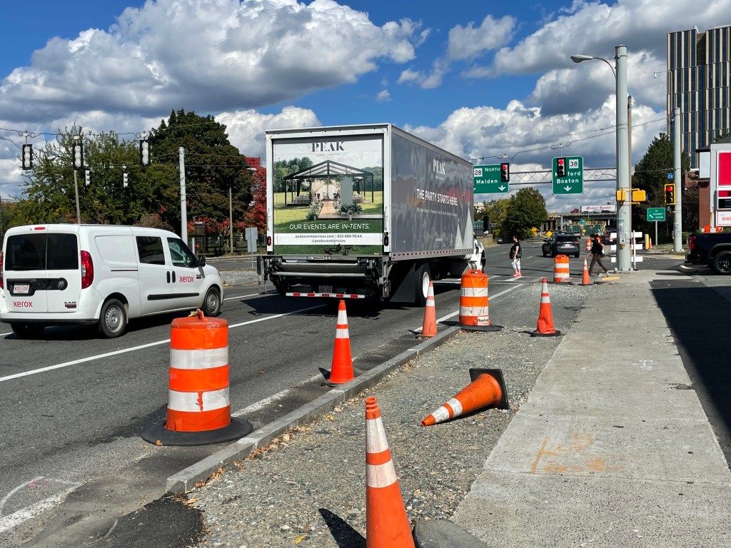
A van and a large box truck stop at a red light on a wide multi-lane street lined with orange construction cones while two people walk across a crosswalk in the middle distance under the traffic light. In the foreground a strip of gravel lies parallel to a concrete sidewalk. Beyond the traffic light are two large green highway signs. One reads "28 NORTH Malden" above two downward pointing arrows, and the other reads "38 Medford Boston" above one downward pointing arrow.
New curbs on McGrath Highway outline the location of a future sidewalk-level bike lane. In the middle distance, two people are crossing the recently-upgraded crosswalk at Blakeley Avenue.

In addition to that new path, another 10-foot-wide shared-use pathway now runs under the I-93 viaduct along the north side of Mystic Avenue, heading west towards the signalized crosswalk at Wheatland Street (pictured below). Another sidewalk-level protected bike lane is under construction across the street, along the northern edge of Foss Park.
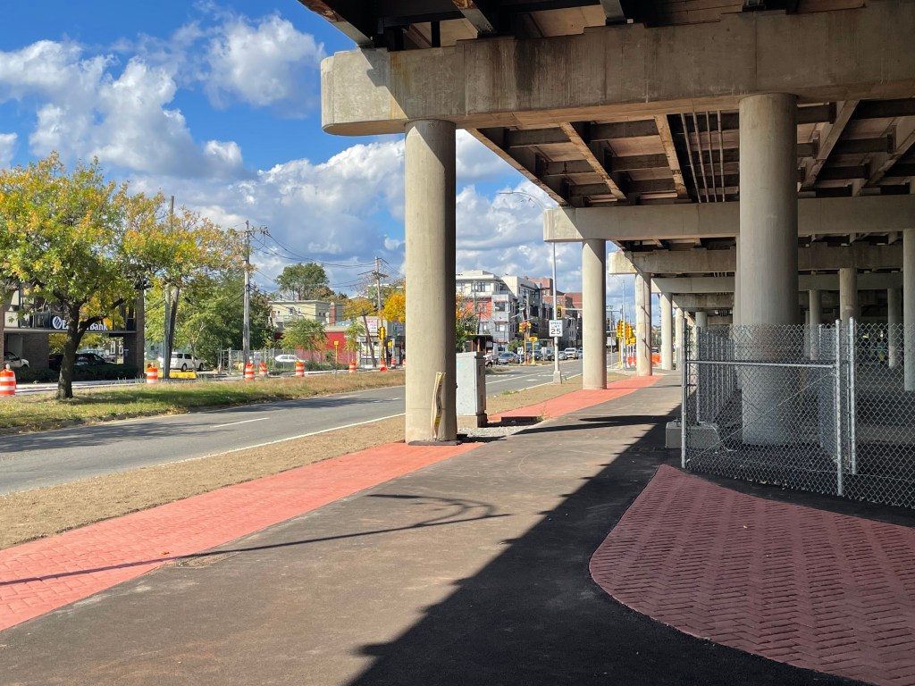
A wide asphalt path runs under the edge of an elevated highway viaduct next to a wide multi-lane surface road with city buildings on the other side. A sign in the middle distance reads "SPEED LIMIT 25".
A newly-built shared-use path runs along the northern edge of Mystic Avenue under the I-93 viaduct. Before this project, there had been no sidewalk on the northern edge of Mystic Avenue in this location.

Rawson told StreetsblogMASS that once these projects are finished late next year, work will transition to the long-awaited redesign of McGrath Boulevard, which will extend the bike and pedestrian improvements further south through the rest of the city.

“We have fought for so long and so hard to get that project moving,” said Rawson. “Folks, it’s no longer a vision, it’s a committed project. It’s scheduled to get underway about 15 months from now.”

Less deadly, but still dreary

For people who live in the neighborhood and walk along these streets, the changes are appreciated, but not exactly transformative.

“There have been fewer crashes, and no deaths, which is great,” says Emily Vides, who lives nearby and frequently walks and rides the bus along Mystic Avenue. “But people still speed all the time.”

Vides is also frustrated at how the construction has ripped up some of the new accessible crosswalks and curb ramps that MassDOT had just installed in 2022. In several locations, older crosswalk markings dead-end in piles of dirt, or at inaccessible curbs (see photo below).

There’s also no signage on site to indicate how pedestrians should navigate through the construction zone. When StreetsblogMASS visited the area on October 8 and on October 21, we saw several people walking in the Mystic Avenue roadway because the sidewalks were not accessible.
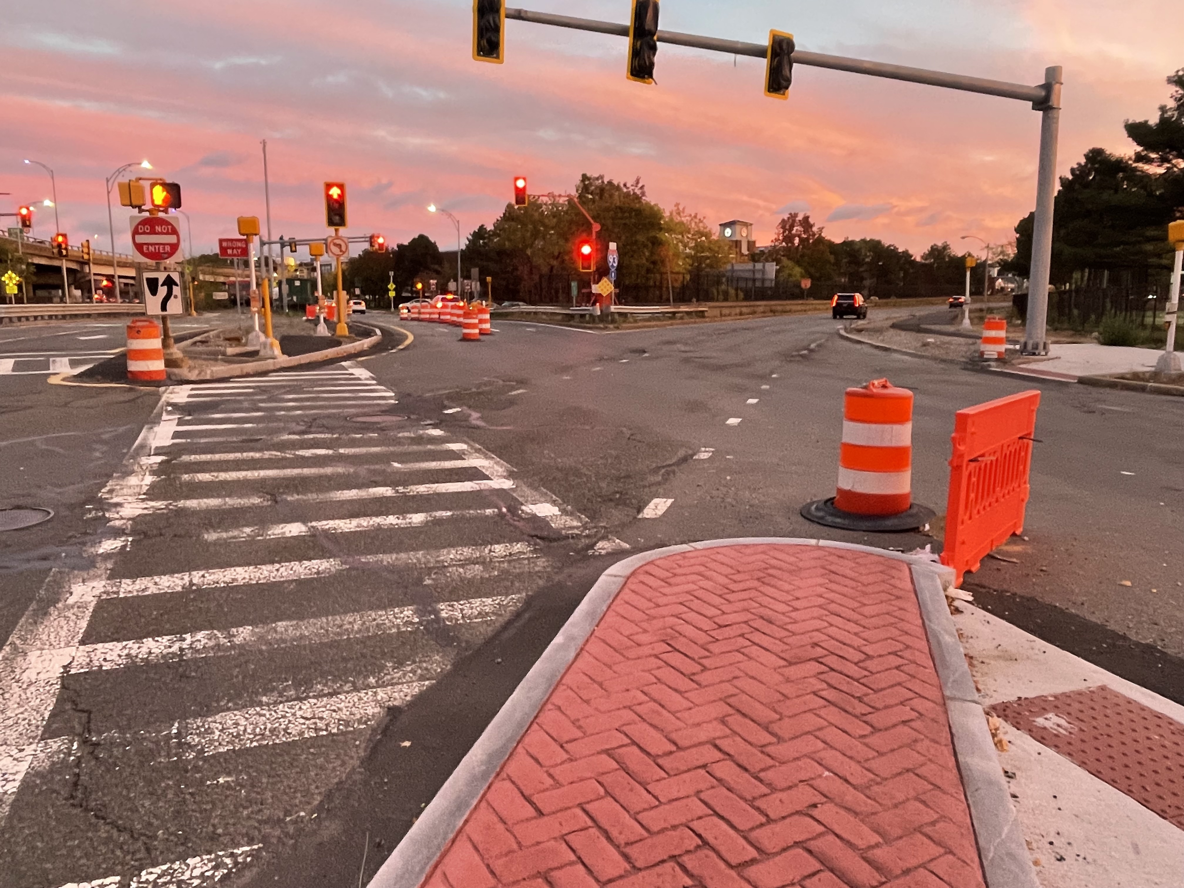
A photo of a complex intersection with numerous orange construction barrels and barriers at sunset.
Old crosswalk markings at the intersection of Mystic Avenue (left) and McGrath Highway (right) show old crosswalk markings that are no longer accessible to wheelchair users. A new accessible route is being planned on the south side of Mystic Avenue (along the guardrail in the center of this photo), at which point the existing sidewalk in the center median will be discontinued. Photographed on Wed. Oct. 21, 2026.

“When people are going 30 to 40 mph five feet away from you – welcome to the indignity of Mystic Avenue,” scoffs Vides. “There’s no pedestrian detour in place, and it’s always matter of time before someone gets hurt again.”


For more detailed plans of what MassDOT is building in the area, download their March 2023 public information presentation here.

Photo of Christian MilNeil
Christian has edited StreetsblogMASS since its founding in spring 2019. Before that, he was a data reporter for the Portland Press Herald in Maine. Got tips? Send them to me via Signal, the encrypted messaging app, at 207-310-0728.

Read More:

Streetsblog has migrated to a new comment system. New commenters can register directly in the comments section of any article. Returning commenters: your previous comments and display name have been preserved, but you'll need to reclaim your account by clicking "Forgot your password?" on the sign-in form, entering your email, and following the verification link to set a new password — this is required because passwords could not be carried over during the migration. For questions, contact tips@streetsblog.org.
More from Streetsblog Massachusetts

This Sunday: ‘Ride For Your Life’ Event Brings Safety Demands to Beacon Hill

October 22, 2026

Thursday’s Headlines Play the Blame Game

October 22, 2026

The T’s New Subway Car Contract Enters Its Awkward Teen Years

October 21, 2026

More Details on Boston’s New, Free ‘Link Bus’ Shuttle Program

October 20, 2026

MBTA Boosts Orange Line Subway Speeds Again

October 19, 2026
See all posts