Somerville’s ‘Grounding McGrath’ Plan Has A New Look, With Fewer Lanes
A plan to transform Somerville’s McGrath Highway into a narrower, tree-lined boulevard is getting closer to reality.
At a virtual public hearing on Tuesday evening, officials from MassDOT and the City of Somerville announced that work to demolish the obsolete highway could begin by 2028.
‘Grounding McGrath’ planned for a decade
MassDOT and Somerville have been debating what to do about the McGrath Highway’s crumbling overpasses since the early 2010s.
In a 2013 study on the highway’s future titled “Grounding McGrath,” MassDOT called the roadway “antiquated,” with “physically deteriorated” viaducts that represented “an outdated approach to road building.”
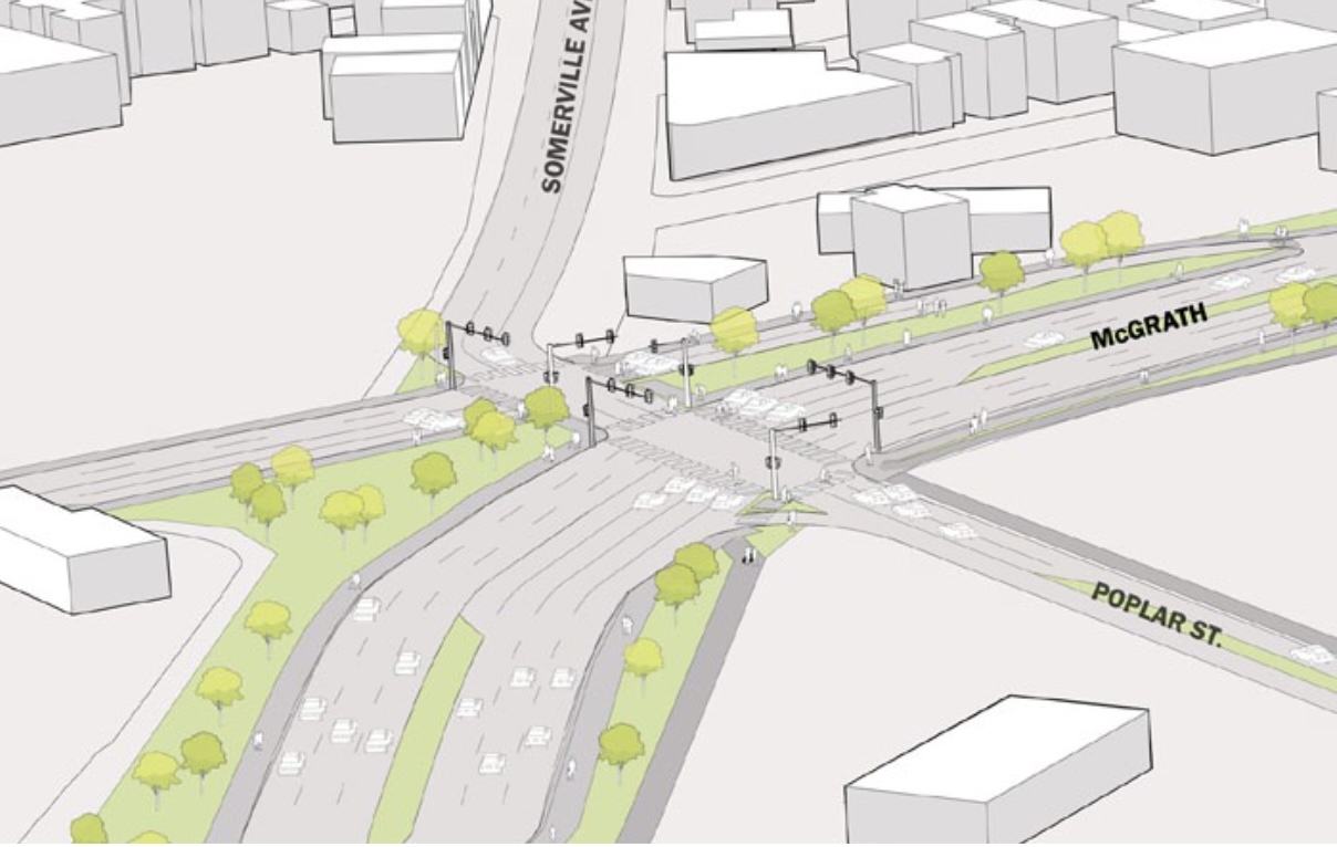
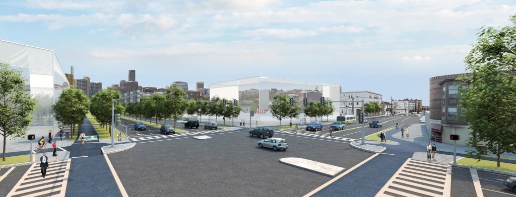
The Grounding McGrath study recommended replacing the highway with a huge at-grade boulevard that would have been 6 to 7 lanes wide (see rendering above).
But despite pressure from former Somerville Mayor Joe Curtatone, who wrote in 2019 that “I’d rip down McGrath with my bare hands if I could,” MassDOT’s plans collected dust for a lack of funding – until now.
New design features narrower roadway, more greenery
The state’s capital investment plan has booked the McGrath project for funding in 2027, which means that MassDOT is finally dusting off its plans and putting the project into the formal design phase.
There’s a silver lining to the long delay: the Commonwealth’s new designs for McGrath Boulevard feature fewer lanes for traffic, and more space for trees, dedicated bike paths, and potential new housing.
In general, the new street would feature two lanes in each direction for vehicular traffic, plus additional turn lanes at intersections.
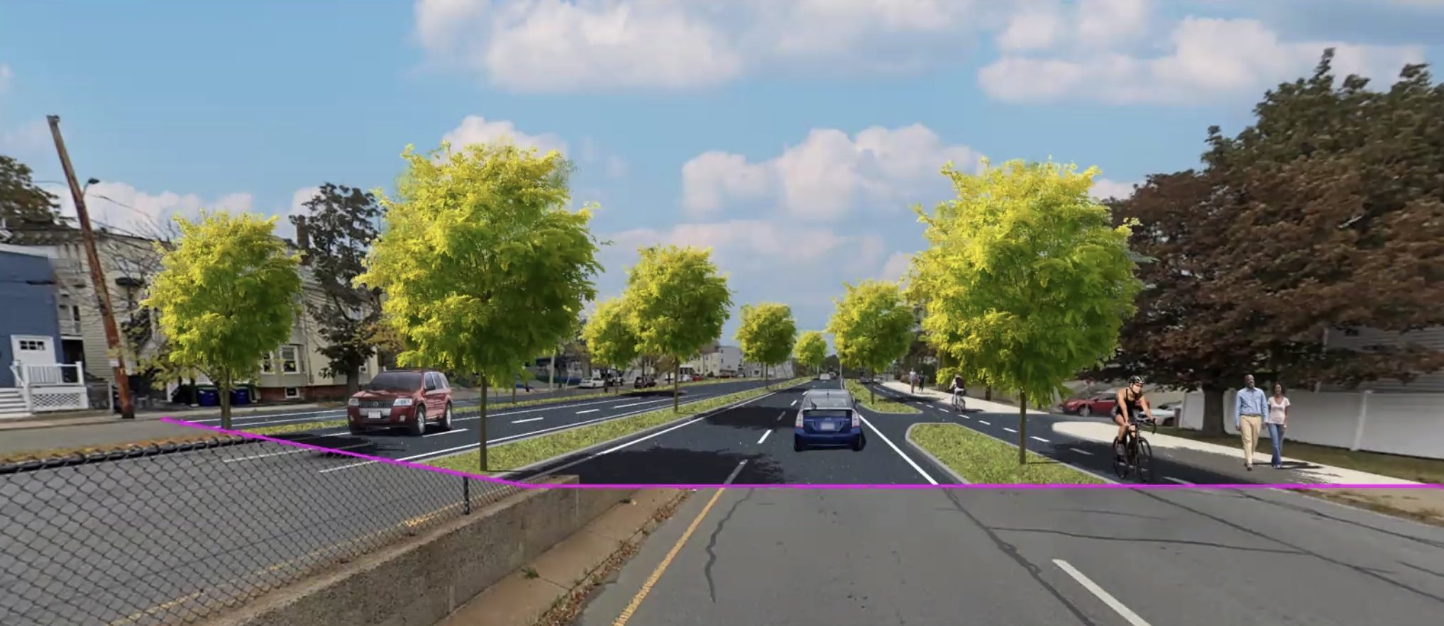
Wider, landscaped areas planted with trees would replace the highway’s existing concrete barriers.
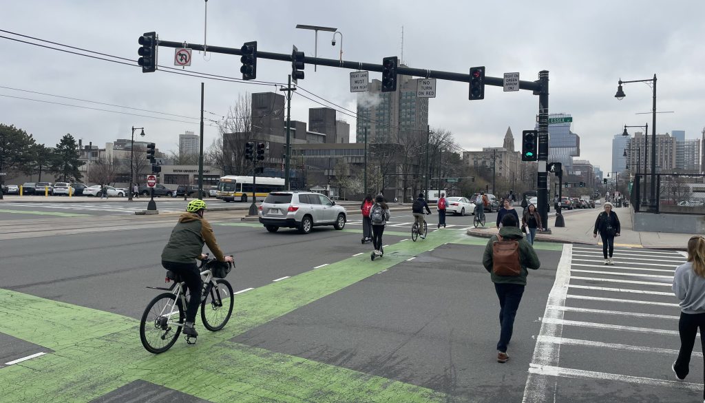
The project would also create a continuous, two-way protected bike path along the eastern side of the new boulevard. In many locations, plans call for additional protected bike infrastructure on the southbound side of the new street as well.
The widest part of the new boulevard would be at its intersection with Washington Street, where MassDOT plans a six-lane cross-section to accommodate space for bus stops and turn lanes.
The design also calls for a new two-way protected bike path on the south side of Washington Street between McGrath and the Community Path access point at the East Somerville Green Line station:
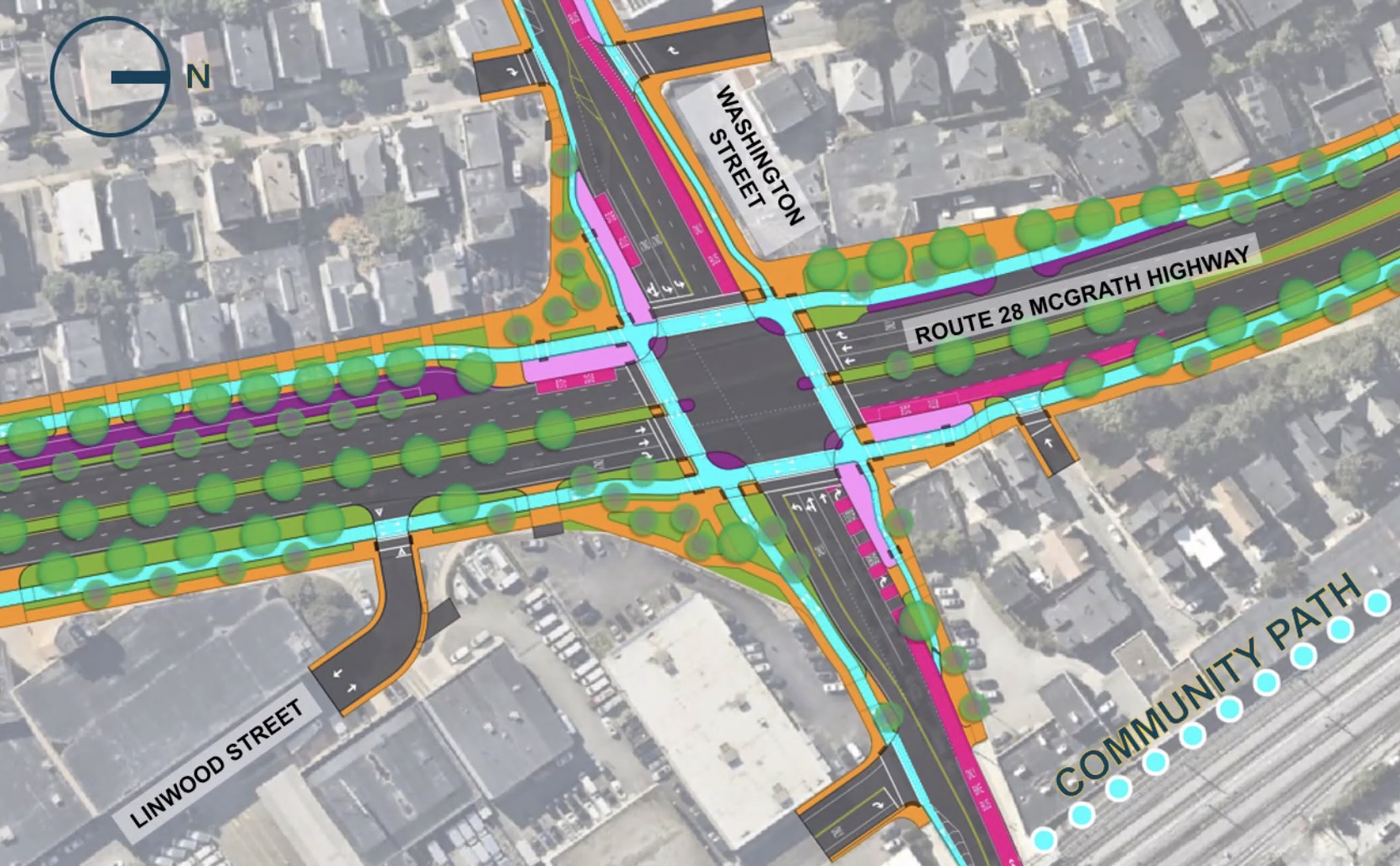
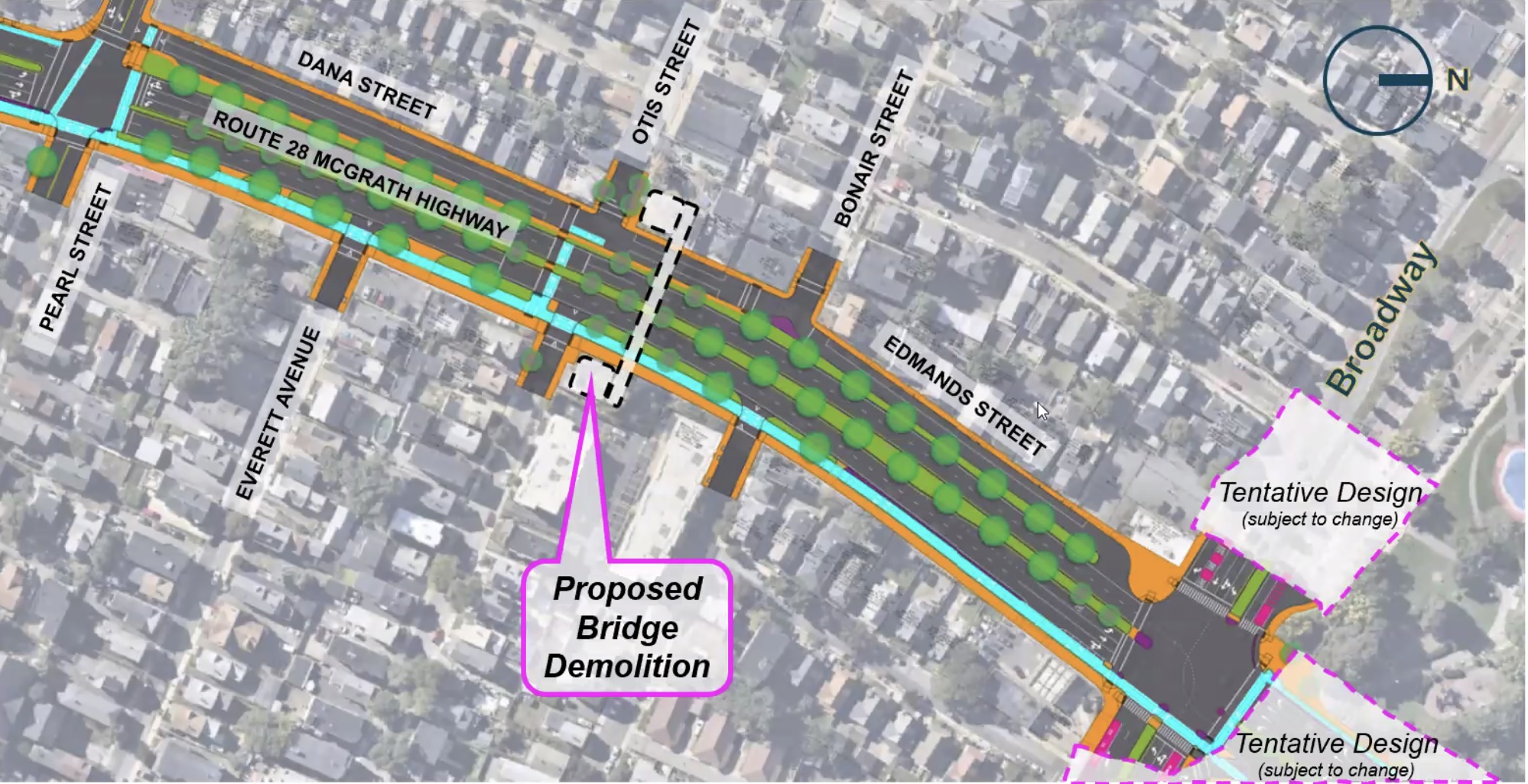
Several of the plans that MassDOT shared at Tuesday’s meeting included greyed-out areas labeled “tentative design subject to change.”
The project’s designers are trying to coordinate this project with numerous others that are in the planning stages, including private-sector real estate developments in the Brickbottom neighborhood and new street designs around Foss Park.
Some neighbors press for an even narrower street
Although the current plans would make McGrath smaller, the proposed boulevard would still be one of the widest streets in Somerville.
During a question-and-answer session after MassDOT’s presentation Tuesday evening, several meeting participants asked whether the road could be even narrower. Others suggested repurposing some of the public land for better uses, like housing.
“It’s a little surprising to me that this proposed design would use every single inch of space that’s already taken up by this road right-of-way… This feels like a missed opportunity to decrease the physical footprint of the roadway,” observed one meeting attendee.
“We can revisit and potentially revise that configurations and the cross-sections at intersections,” responded project consultant Gary McNaughton. “We’ve heard loud and clear, let’s not worry about traffic operations. That is not a goal of this project. We are reducing capacity. We are taking away vehicle capacity. And we will continue to do that as we advance that design we’ll look for further opportunities.”
2013 design based on bad traffic forecasts
For the 2013 Grounding McGrath study, highway engineers attempted to predict future traffic volumes with the CTPS travel demand model.
“Automobile trips along the McGrath corridor are expected to increase in the range of 7.5 percent to 12.5 percent between 2011 and 2035, depending on the segment of the corridor,” CTPS predicted.
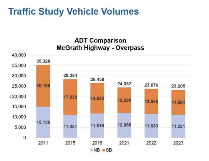
Those forecasts were wildly off the mark. In 2023, the highway’s actual traffic volume was about two-thirds of what it was in 2011.
In the busier southbound direction – where drivers often use McGrath to try and dodge traffic jams on I-93 – traffic has declined by over 40 percent.
“We are seeing trends in traffic that continue to reveal that McGrath Highway is overbuilt,” said McNaughton, the project’s design consultant.
A McGrath busway is unlikely
Several other participants asked about the proposal’s lack of bus lanes.
“It’s not just a matter of what you can fit, but what serves the demand for transit,” responded McNaughton. “(During preliminary design) the Silver Line Extension alternatives analysis was ongoing… the MBTA was working on their bus network redesign as well. And quite honestly, neither of those efforts saw this corridor as having a heavy bus transit demand.”
McNaughton added that the project would also rebuild a section of Washington Street with a dedicated bus lane through its intersection with the new McGrath.
The City of Boston recently committed to building center-running bus lanes in its upcoming rebuild of nearby Rutherford Avenue, a similarly obsolete highway.
Extensive design needs postpone project schedule
The project team expects to spend the next few years refining the design.
Several participants at Tuesday’s meeting asked why it can’t happen sooner.
“There’s a lot of moving parts on this project,” said Christopher Cameron, a MassDOT project manager.
The project team needs to coordinate with utilities and adjacent construction projects and finalize environmental permitting.
“Four years is really the time we’re going to need to get through that process,” explained McNaughton. “We understand the desire to move it along and we agree. But that is the process that we need to follow.”

Read More:
Streetsblog has migrated to a new comment system. New commenters can register directly in the comments section of any article. Returning commenters: your previous comments and display name have been preserved, but you'll need to reclaim your account by clicking "Forgot your password?" on the sign-in form, entering your email, and following the verification link to set a new password — this is required because passwords could not be carried over during the migration. For questions, contact tips@streetsblog.org.