MassDOT’s Riverfront Interchange Plans In Cambridge Get a Little Smaller
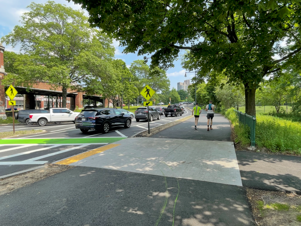
MassDOT has released two new conceptual designs for a possible replacement of the Reid Overpass highway interchange – the crumbling, traffic-clogged rotary that blights Cambridge’s riverfront parkland at the northern end of the Boston University Bridge.
The Reid Overpass and the traffic circle around its base lie is a key entry point for vehicles, bikes, and pedestrians traveling between Boston and the Cambridgeport neighborhood.
The interchange is also part of Memorial Drive, the four-lane riverfront highway that limits access and threatens public safety along Cambridge’s riverfront.
In a January public hearing, MassDOT officials warned that the “existing rotary and viaduct are deteriorated (and) outdated.”
The roadway’s design “no longer reflects current best practices for safety, efficiency, or multimodal access,” added Anthony Timperio of Benesch, a private-sector engineering firm.
Designing for traffic vs. designing for safety
At that same public hearing in January, MassDOT presented four conceptual designs for new, large-scale highway interchanges that could potentially replace the crumbling Reid Overpass sometime in the 2030s.
The options (which you can read more about in our coverage of that January meeting) included an at-grade four-way intersection that would have nearly doubled the width of Memorial Drive through the project area, plus several grade-separated interchange concepts with high-speed slip lanes designed to speed motor vehicles through a web of on- and off-ramps.
Those proposals got a chilly reception from neighbors and local elected officials, who urged MassDOT to scale down the size of their proposals to improve safety, support regional traffic reduction goals, and cut costs.
Advocates also pointed out that MassDOT’s plans were inconsistent with another project that’s well under construction on the same roadway, one mile up the river.
Between John F. Kennedy Street near Harvard Square and the Eliot Bridge, the Department of Conservation and Recreation (DCR) is currently tearing out two lanes of asphalt on Memorial Drive to free up more land for trees and the riverfront pathway, and convert Memorial Drive into a calmer 2-lane parkway.
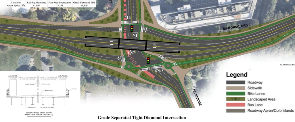
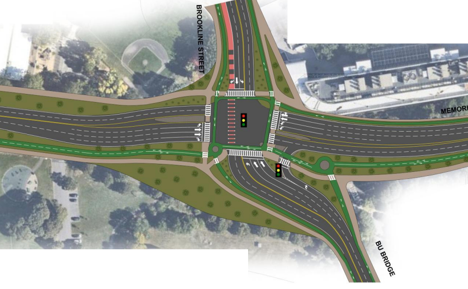
Following the lackluster reception for its initial interchange concepts in January, MassDOT returned to Cambridge last week to present two new options, both of which feature considerably less asphalt.
One option would rebuild a smaller highway overpass for two lanes of through-running traffic on Memorial Drive, with on- and off-ramps leading to two new traffic signals on either side of the overpass:
The other concept would eliminate the overpass, and consolidate all traffic through a large at-grade intersection.
Chris Cassa, a volunteer with Cambridge Bike Safety who’s been following MassDOT’s plans closely, says that the agency’s revised designs are a big improvement over what they’d presented in January.
“There’s been a ton a progress,” he told StreetsblogMASS. “They’ve come a long way. We’d still love them to do more to address the speeding hazards with more traffic-calming infrastructure… We pushed for some kind of gateway up and down the on-ramps, to have a median island or some kind, and narrower shoulders.”
A five-lane funnel into single-lane streets
Rep. Mike Connolly, whose district includes parts of Cambridgeport, also expressed appreciation for MassDOT’s willingness to listen to its critics in a phone conversation with StreetsblogMASS last week.
He noted that the state’s latest plans take a big step towards integrating with the narrow single-lane, one-way streets of Cambridgeport, which lie just to the north of the traffic circle.
But he also raised the neighborhood’s concerns that MassDOT is still trying to funnel too much traffic into the neighborhood.
“I appreciate the direction that MassDOT is headed in,” Connolly told StreetsblogMASS. “One other big component of this is how important it will be to integrate and collaborate with the City of Cambridge on how the state’s infrastructure impacts the Cambridgeport neighborhood, and the 47 bus that perpetually gets stuck at this roundabout.”
The City of Cambridge has a new zero-emissions transportation plan that calls for reducing local and regional traffic on its streets, in addition to a “vehicle trip reduction ordinance” that requires new developments to prioritize bike, pedestrian, and public transit access.
On the state level, Governor Healey’s climate office has also told MassDOT that it will need to reduce traffic statewide – and in transit-accessible cities like Cambridge in particular – in order for Massachusetts to meet its climate goals.
But in spite of those mandates, MassDOT spokesperson John Goggin confirmed to StreetsblogMASS that the agency has been designing the Reid overpass replacement to “accommodate the vehicle volumes and travel needs of the intersection/overpass today, as well as reasonably estimated future conditions.”
“As the project designs advance, MassDOT will continue to coordinate with the Cities of Cambridge and Boston, as well as DCR, and incorporate agreed-upon changes to the local roadway network and traffic assignments into the analysis,” Goggin added.

Streetsblog has migrated to a new comment system. New commenters can register directly in the comments section of any article. Returning commenters: your previous comments and display name have been preserved, but you'll need to reclaim your account by clicking "Forgot your password?" on the sign-in form, entering your email, and following the verification link to set a new password — this is required because passwords could not be carried over during the migration. For questions, contact tips@streetsblog.org.