MassDOT Is Filling Gaps In the Border to Boston Trail
MassDOT will host two public design hearings over the next two weeks for its plans to fill in some of the remaining gaps on the Border to Boston trail, a 70-mile network of off-street bike paths between Seabrook, New Hampshire and downtown Boston.
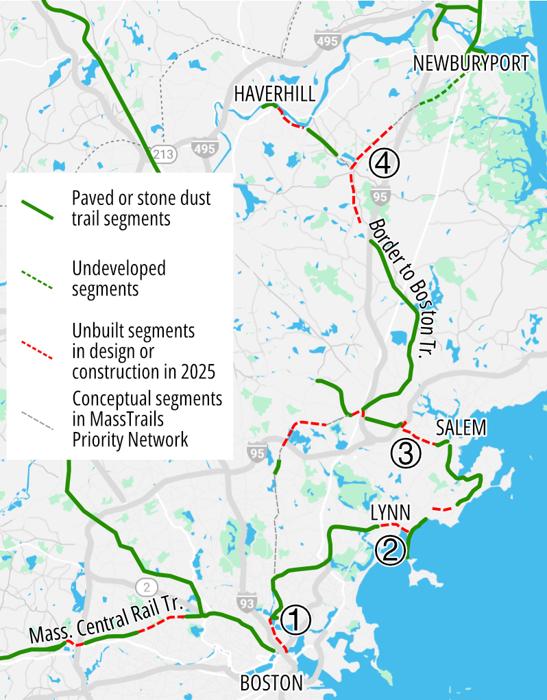
Much of the Border-to-Boston trail is already complete (see map at left). But large segments of it – especially in the more rural areas of Essex County – consist of little more than a single dirt track along the abandoned Newburyport Railroad line.
In several locations, large barriers like Interstate 95 and the Mystic River cut off the trail corridor entirely.
But with several construction projects that are underway now or scheduled to begin soon, MassDOT is steadily closing those gaps and polishing the edges off the trail’s roughest segments.
Here’s a roundup of what the agency is working on:
Mystic River Bridge
On Monday, May 12th, MassDOT will host an in-person public hearing in Somerville on its updated design for the Mystic River bike and pedestrian bridge between Somerville and Everett (marked with a 1 in the map above).
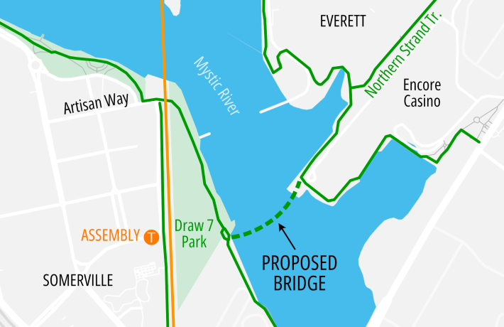
At a March 4th meeting of the Assembly Connect transportation management association, MassDOT project manager William Conroy confirmed that the new bridge design would provide a wider, 18-foot deck. Conroy also said that the agency is aiming to begin construction before the end of 2026.
The proposed bridge will extend the Northern Strand trail over the Mystic River, connecting the Encore Casino site in Everett to Draw Seven Park near the Assembly Orange Line station in Somerville.
The bridge will also link the Northern Strand trail to the Charlestown Seawall pathway, which runs along the western bank of the river to Alford Street in Boston. A future reconstruction of Rutherford Avenue will extend that off-street pathway all the way to the Paul Dudley White paths on the Charles River and into downtown Boston via the new Bill Russell Bridge.
Northern Strand through downtown Lynn
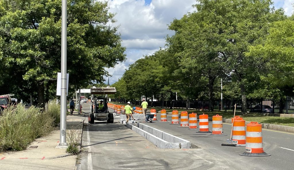
At the other end of the Northern Strand trail, in downtown Lynn, progress continues on a new on-street protected bike path that extends from Lynn Common to the ocean at Nahant Beach (marked with a 2 in the map above).
Construction of the curb-protected bikeway has been underway since last summer (the photo at the top of this story, which we took on a Border-to-Boston bike tour last summer, shows curbs going in along the Lynnway, where the new bike path will replace one of the highway’s six motor vehicle lanes).
In an April 13th update for the Lynn Daily Item, Isaac Green reports that “crews are currently installing new signal equipment along the multi-use path, with the project expected to be completed by November 2026.”
Peabody Independence Greenway extensions
In Peabody, where the Border to Boston route follows the city’s incomplete Independence Greenway, MassDOT could break ground on two trail projects this year.
The existing Independence Greenway is made up of two disconnected segments that are divided by two huge highways, Route 1 and Interstate 95. In the middle of that gap, the Danvers Rail Trail (another segment of the Border to Boston route) currently ends at a hard-to-find trailhead between a gas station and an interstate highway overpass.
Within the next year, MassDOT plans to begin construction on a $19 million project to connect those three pathways with a new bike and pedestrian bridge over Route 1 and an upgraded shared-use path connection under Interstate 95.
A separate project, also expected to break ground within the next year, will extend the eastern end of the Independence Greenway 1.3 miles closer towards downtown Peabody and Salem.
That project (marked with a 3 in the map above) will bring the Greenway around the edge of the North Shore Mall parking lot, under the Route 128 expressway, then run alongside Proctor Brook to Endicott Street at the edge of Peabody’s downtown.
Boxford, Georgetown, and Newbury
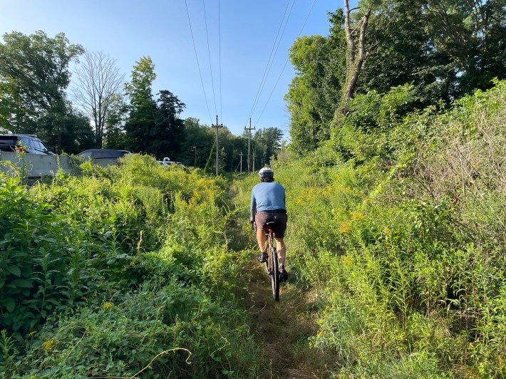
This Thursday, May 1st, MassDOT will host a virtual public hearing for a 3.3-mile trail upgrade on the Border to Boston trail between the small village centers of Georgetown and Byfield in Essex County (marked 4 in the map above).
This is a trail segment that’s technically open to the public, but it doesn’t get that much traffic because a lot of it looks like this:
MassDOT is actually planning two separate projects to bring this section of the trail up to its standards for accessibility. The Georgetown-to-Byfield segment could begin construction in 2028, according to the agency’s project database.
Another project, tentatively scheduled for construction in 2027, would upgrade the 2.4-mile segment south of Georgetown center, from West Main Street in Georgetown to Georgetown Road in the town of Boxford.
If you’d like to explore more of what this part of the trail looks like currently, a contributor named Phil Turland added “street view” imagery to Google Maps in 2023.

Read More:
Streetsblog has migrated to a new comment system. New commenters can register directly in the comments section of any article. Returning commenters: your previous comments and display name have been preserved, but you'll need to reclaim your account by clicking "Forgot your password?" on the sign-in form, entering your email, and following the verification link to set a new password — this is required because passwords could not be carried over during the migration. For questions, contact tips@streetsblog.org.